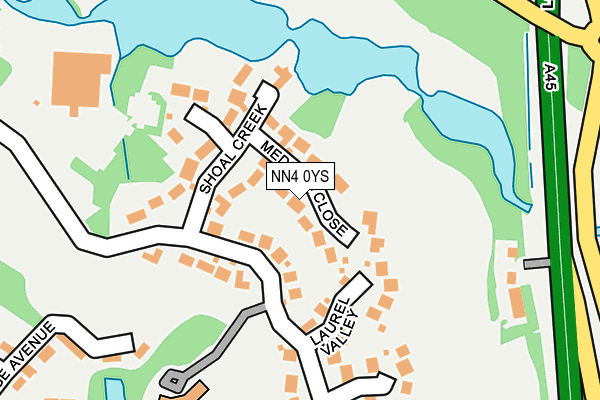
NN4 0YS lies on Medinah Close in Northampton. NN4 0YS is located in the East Hunsbury and Shelfleys electoral ward, within the unitary authority of West Northamptonshire and the English Parliamentary constituency of South Northamptonshire. The Sub Integrated Care Board (ICB) Location is NHS Northamptonshire ICB - 78H and the police force is Northamptonshire. This postcode has been in use since August 1992.


GetTheData
Source: OS OpenMap – Local (Ordnance Survey)
Source: OS VectorMap District (Ordnance Survey)
Licence: Open Government Licence (requires attribution)
| Easting | 475526 |
| Northing | 256023 |
| Latitude | 52.197278 |
| Longitude | -0.896418 |
GetTheData
Source: Open Postcode Geo
Licence: Open Government Licence
| Street | Medinah Close |
| Town/City | Northampton |
| Country | England |
| Postcode District | NN4 |
➜ See where NN4 is on a map ➜ Where is Collingtree? | |
GetTheData
Source: Land Registry Price Paid Data
Licence: Open Government Licence
Elevation or altitude of NN4 0YS as distance above sea level:
| Metres | Feet | |
|---|---|---|
| Elevation | 70m | 230ft |
Elevation is measured from the approximate centre of the postcode, to the nearest point on an OS contour line from OS Terrain 50, which has contour spacing of ten vertical metres.
➜ How high above sea level am I? Find the elevation of your current position using your device's GPS.
GetTheData
Source: Open Postcode Elevation
Licence: Open Government Licence
| Ward | East Hunsbury And Shelfleys |
| Constituency | South Northamptonshire |
GetTheData
Source: ONS Postcode Database
Licence: Open Government Licence
2023 21 APR £1,325,000 |
4, MEDINAH CLOSE, NORTHAMPTON, NN4 0YS 2014 23 JAN £880,000 |
2010 18 AUG £615,000 |
2006 19 OCT £635,000 |
10, MEDINAH CLOSE, NORTHAMPTON, NN4 0YS 2006 1 SEP £525,000 |
2004 19 OCT £499,995 |
9, MEDINAH CLOSE, NORTHAMPTON, NN4 0YS 2004 19 JUL £499,995 |
2004 25 MAR £567,000 |
2003 17 APR £600,000 |
2001 7 DEC £540,000 |
GetTheData
Source: HM Land Registry Price Paid Data
Licence: Contains HM Land Registry data © Crown copyright and database right 2025. This data is licensed under the Open Government Licence v3.0.
| Golf Course (London Road) | Collingtree | 246m |
| Langford Drive (Berry Lane) | Wootton | 439m |
| Langford Drive (Berry Lane) | Wootton | 459m |
| Marjoram Close (Rowtree Road) | Blackey More | 479m |
| Tarragon Way (Butts Road) | Blackey More | 636m |
| Northampton Station | 4.5km |
GetTheData
Source: NaPTAN
Licence: Open Government Licence
| Percentage of properties with Next Generation Access | 100.0% |
| Percentage of properties with Superfast Broadband | 100.0% |
| Percentage of properties with Ultrafast Broadband | 100.0% |
| Percentage of properties with Full Fibre Broadband | 0.0% |
Superfast Broadband is between 30Mbps and 300Mbps
Ultrafast Broadband is > 300Mbps
| Median download speed | 39.6Mbps |
| Average download speed | 85.6Mbps |
| Maximum download speed | 200.00Mbps |
| Median upload speed | 6.3Mbps |
| Average upload speed | 6.3Mbps |
| Maximum upload speed | 6.47Mbps |
| Percentage of properties unable to receive 2Mbps | 0.0% |
| Percentage of properties unable to receive 5Mbps | 0.0% |
| Percentage of properties unable to receive 10Mbps | 0.0% |
| Percentage of properties unable to receive 30Mbps | 0.0% |
GetTheData
Source: Ofcom
Licence: Ofcom Terms of Use (requires attribution)
Estimated total energy consumption in NN4 0YS by fuel type, 2015.
| Consumption (kWh) | 432,591 |
|---|---|
| Meter count | 11 |
| Mean (kWh/meter) | 39,326 |
| Median (kWh/meter) | 42,815 |
| Consumption (kWh) | 68,293 |
|---|---|
| Meter count | 8 |
| Mean (kWh/meter) | 8,537 |
| Median (kWh/meter) | 7,404 |
GetTheData
Source: Postcode level gas estimates: 2015 (experimental)
Source: Postcode level electricity estimates: 2015 (experimental)
Licence: Open Government Licence
GetTheData
Source: ONS Postcode Database
Licence: Open Government Licence


➜ Get more ratings from the Food Standards Agency
GetTheData
Source: Food Standards Agency
Licence: FSA terms & conditions
| Last Collection | |||
|---|---|---|---|
| Location | Mon-Fri | Sat | Distance |
| Windingbrook Lane | 17:30 | 11:45 | 486m |
| Berry Lane | 17:30 | 12:00 | 521m |
| Collingtree | 17:30 | 10:45 | 660m |
GetTheData
Source: Dracos
Licence: Creative Commons Attribution-ShareAlike
The below table lists the International Territorial Level (ITL) codes (formerly Nomenclature of Territorial Units for Statistics (NUTS) codes) and Local Administrative Units (LAU) codes for NN4 0YS:
| ITL 1 Code | Name |
|---|---|
| TLF | East Midlands (England) |
| ITL 2 Code | Name |
| TLF2 | Leicestershire, Rutland and Northamptonshire |
| ITL 3 Code | Name |
| TLF24 | West Northamptonshire |
| LAU 1 Code | Name |
| E07000154 | Northampton |
GetTheData
Source: ONS Postcode Directory
Licence: Open Government Licence
The below table lists the Census Output Area (OA), Lower Layer Super Output Area (LSOA), and Middle Layer Super Output Area (MSOA) for NN4 0YS:
| Code | Name | |
|---|---|---|
| OA | E00138378 | |
| LSOA | E01027206 | Northampton 031D |
| MSOA | E02005680 | Northampton 031 |
GetTheData
Source: ONS Postcode Directory
Licence: Open Government Licence
| NN4 0YT | Shoal Creek | 107m |
| NN4 0YU | Laurel Valley | 131m |
| NN4 0XN | Windingbrook Lane | 153m |
| NN4 0XL | Windingbrook Lane | 164m |
| NN4 0YW | Tanglewood | 195m |
| NN4 0NP | London Road | 217m |
| NN4 0EB | Windingbrook Lane | 253m |
| NN4 0BL | Colonial Drive | 316m |
| NN4 0NQ | Lodge Avenue | 323m |
| NN4 0NH | Lake Walk | 347m |
GetTheData
Source: Open Postcode Geo; Land Registry Price Paid Data
Licence: Open Government Licence