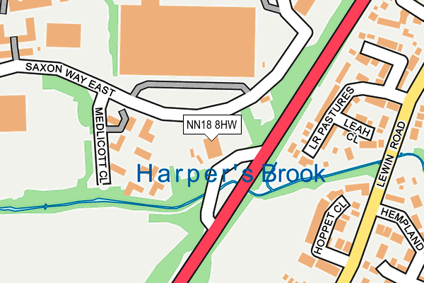
NN18 8HW is located in the Oakley electoral ward, within the unitary authority of North Northamptonshire and the English Parliamentary constituency of Corby. The Sub Integrated Care Board (ICB) Location is NHS Northamptonshire ICB - 78H and the police force is Northamptonshire. This postcode has been in use since January 1980.


GetTheData
Source: OS OpenMap – Local (Ordnance Survey)
Source: OS VectorMap District (Ordnance Survey)
Licence: Open Government Licence (requires attribution)
| Easting | 486264 |
| Northing | 285822 |
| Latitude | 52.463538 |
| Longitude | -0.731716 |
GetTheData
Source: Open Postcode Geo
Licence: Open Government Licence
| Country | England |
| Postcode District | NN18 |
➜ See where NN18 is on a map ➜ Where is Corby? | |
GetTheData
Source: Land Registry Price Paid Data
Licence: Open Government Licence
Elevation or altitude of NN18 8HW as distance above sea level:
| Metres | Feet | |
|---|---|---|
| Elevation | 90m | 295ft |
Elevation is measured from the approximate centre of the postcode, to the nearest point on an OS contour line from OS Terrain 50, which has contour spacing of ten vertical metres.
➜ How high above sea level am I? Find the elevation of your current position using your device's GPS.
GetTheData
Source: Open Postcode Elevation
Licence: Open Government Licence
| Ward | Oakley |
| Constituency | Corby |
GetTheData
Source: ONS Postcode Database
Licence: Open Government Licence
| Hoppet Close (Lewin Road) | Great Oakley | 252m |
| Hoppet Close (Lewin Road) | Great Oakley | 267m |
| Lower Pastures (Lewin Road) | Great Oakley | 289m |
| Lower Pastures (Lewin Road) | Great Oakley | 301m |
| Catalent (Headway) | Great Oakley | 336m |
| Corby Station | 4.1km |
GetTheData
Source: NaPTAN
Licence: Open Government Licence
GetTheData
Source: ONS Postcode Database
Licence: Open Government Licence


➜ Get more ratings from the Food Standards Agency
GetTheData
Source: Food Standards Agency
Licence: FSA terms & conditions
| Last Collection | |||
|---|---|---|---|
| Location | Mon-Fri | Sat | Distance |
| Great Oakley | 16:00 | 08:00 | 1,277m |
| Saxon Way East | 18:00 | 09:00 | 2,030m |
| Farmstead Road | 17:00 | 11:15 | 2,332m |
GetTheData
Source: Dracos
Licence: Creative Commons Attribution-ShareAlike
The below table lists the International Territorial Level (ITL) codes (formerly Nomenclature of Territorial Units for Statistics (NUTS) codes) and Local Administrative Units (LAU) codes for NN18 8HW:
| ITL 1 Code | Name |
|---|---|
| TLF | East Midlands (England) |
| ITL 2 Code | Name |
| TLF2 | Leicestershire, Rutland and Northamptonshire |
| ITL 3 Code | Name |
| TLF25 | North Northamptonshire |
| LAU 1 Code | Name |
| E07000150 | Corby |
GetTheData
Source: ONS Postcode Directory
Licence: Open Government Licence
The below table lists the Census Output Area (OA), Lower Layer Super Output Area (LSOA), and Middle Layer Super Output Area (MSOA) for NN18 8HW:
| Code | Name | |
|---|---|---|
| OA | E00169161 | |
| LSOA | E01026956 | Corby 008D |
| MSOA | E02006862 | Corby 008 |
GetTheData
Source: ONS Postcode Directory
Licence: Open Government Licence
| NN18 8JJ | Lower Pastures | 211m |
| NN18 8JQ | Hoppet Close | 217m |
| NN18 8JU | Leah Close | 224m |
| NN18 8JW | Harden Close | 271m |
| NN18 9NX | Ryder Court | 309m |
| NN18 8LT | Hempland Close | 325m |
| NN18 8HU | Horselease Close | 334m |
| NN18 8FR | Frith Close | 352m |
| NN18 8JR | Breck Close | 353m |
| NN18 8LQ | Hempland Close | 392m |
GetTheData
Source: Open Postcode Geo; Land Registry Price Paid Data
Licence: Open Government Licence