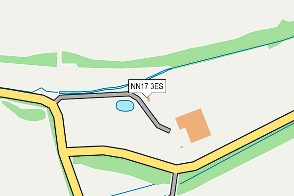
NN17 3ES is located in the Oundle electoral ward, within the unitary authority of North Northamptonshire and the English Parliamentary constituency of Corby. The Sub Integrated Care Board (ICB) Location is NHS Northamptonshire ICB - 78H and the police force is Northamptonshire. This postcode has been in use since October 2009.


GetTheData
Source: OS OpenMap – Local (Ordnance Survey)
Source: OS VectorMap District (Ordnance Survey)
Licence: Open Government Licence (requires attribution)
| Easting | 491769 |
| Northing | 292054 |
| Latitude | 52.518651 |
| Longitude | -0.648996 |
GetTheData
Source: Open Postcode Geo
Licence: Open Government Licence
| Country | England |
| Postcode District | NN17 |
➜ See where NN17 is on a map | |
GetTheData
Source: Land Registry Price Paid Data
Licence: Open Government Licence
Elevation or altitude of NN17 3ES as distance above sea level:
| Metres | Feet | |
|---|---|---|
| Elevation | 90m | 295ft |
Elevation is measured from the approximate centre of the postcode, to the nearest point on an OS contour line from OS Terrain 50, which has contour spacing of ten vertical metres.
➜ How high above sea level am I? Find the elevation of your current position using your device's GPS.
GetTheData
Source: Open Postcode Elevation
Licence: Open Government Licence
| Ward | Oundle |
| Constituency | Corby |
GetTheData
Source: ONS Postcode Database
Licence: Open Government Licence
| Weldon Lodge Farm (Gretton Road) | Weldon Industry | 789m |
| Weldon Lodge Farm (Gretton Road) | Weldon Industry | 789m |
| Kirby Hall (Kirby Lane) | Deene | 821m |
| Kirby Hall (Kirby Lane) | Deene | 840m |
| Corby Business Academy (Off Gretton Road) | Weldon Industry | 1,297m |
| Corby Station | 4.3km |
GetTheData
Source: NaPTAN
Licence: Open Government Licence
GetTheData
Source: ONS Postcode Database
Licence: Open Government Licence


➜ Get more ratings from the Food Standards Agency
GetTheData
Source: Food Standards Agency
Licence: FSA terms & conditions
| Last Collection | |||
|---|---|---|---|
| Location | Mon-Fri | Sat | Distance |
| Corby Road | 17:00 | 08:15 | 2,216m |
| Weldon Tso | 16:45 | 11:00 | 2,841m |
| Bulwick Tso | 16:00 | 10:30 | 2,989m |
GetTheData
Source: Dracos
Licence: Creative Commons Attribution-ShareAlike
The below table lists the International Territorial Level (ITL) codes (formerly Nomenclature of Territorial Units for Statistics (NUTS) codes) and Local Administrative Units (LAU) codes for NN17 3ES:
| ITL 1 Code | Name |
|---|---|
| TLF | East Midlands (England) |
| ITL 2 Code | Name |
| TLF2 | Leicestershire, Rutland and Northamptonshire |
| ITL 3 Code | Name |
| TLF25 | North Northamptonshire |
| LAU 1 Code | Name |
| E07000152 | East Northamptonshire |
GetTheData
Source: ONS Postcode Directory
Licence: Open Government Licence
The below table lists the Census Output Area (OA), Lower Layer Super Output Area (LSOA), and Middle Layer Super Output Area (MSOA) for NN17 3ES:
| Code | Name | |
|---|---|---|
| OA | E00137552 | |
| LSOA | E01027043 | East Northamptonshire 001B |
| MSOA | E02005629 | East Northamptonshire 001 |
GetTheData
Source: ONS Postcode Directory
Licence: Open Government Licence
| NN17 5FR | Osprey Drive | 837m |
| NN17 3FB | Harrier Close | 880m |
| NN17 5FF | Hobby Drive | 947m |
| NN17 3FD | Eagle Close | 965m |
| NN17 5FG | Hobby Drive | 979m |
| NN17 5FP | Kestrel Road | 999m |
| NN17 3BW | Corby Road | 1250m |
| NN17 5XH | Shelton Road | 1446m |
| NN17 5ED | Lilford Place | 1521m |
| NN17 5EL | Barnwell Gardens | 1582m |
GetTheData
Source: Open Postcode Geo; Land Registry Price Paid Data
Licence: Open Government Licence