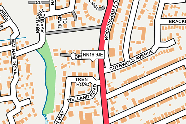
NN16 9JE lies on Rockingham Road in Kettering. NN16 9JE is located in the Clover Hill electoral ward, within the unitary authority of North Northamptonshire and the English Parliamentary constituency of Kettering. The Sub Integrated Care Board (ICB) Location is NHS Northamptonshire ICB - 78H and the police force is Northamptonshire. This postcode has been in use since January 1980.


GetTheData
Source: OS OpenMap – Local (Ordnance Survey)
Source: OS VectorMap District (Ordnance Survey)
Licence: Open Government Licence (requires attribution)
| Easting | 486436 |
| Northing | 280346 |
| Latitude | 52.414293 |
| Longitude | -0.730600 |
GetTheData
Source: Open Postcode Geo
Licence: Open Government Licence
| Street | Rockingham Road |
| Town/City | Kettering |
| Country | England |
| Postcode District | NN16 |
➜ See where NN16 is on a map ➜ Where is Kettering? | |
GetTheData
Source: Land Registry Price Paid Data
Licence: Open Government Licence
Elevation or altitude of NN16 9JE as distance above sea level:
| Metres | Feet | |
|---|---|---|
| Elevation | 80m | 262ft |
Elevation is measured from the approximate centre of the postcode, to the nearest point on an OS contour line from OS Terrain 50, which has contour spacing of ten vertical metres.
➜ How high above sea level am I? Find the elevation of your current position using your device's GPS.
GetTheData
Source: Open Postcode Elevation
Licence: Open Government Licence
| Ward | Clover Hill |
| Constituency | Kettering |
GetTheData
Source: ONS Postcode Database
Licence: Open Government Licence
| Furnace Lane (Rockingham Road) | Kettering | 84m |
| Mendip Close (Pennine Way) | Kettering | 167m |
| Furnace Lane (Rockingham Road) | Kettering | 188m |
| 15 Neale Avenue (Neale Avenue) | Kettering | 202m |
| Satra House (Rockingham Road) | Kettering | 212m |
| Kettering Station | 2.3km |
GetTheData
Source: NaPTAN
Licence: Open Government Licence
| Percentage of properties with Next Generation Access | 100.0% |
| Percentage of properties with Superfast Broadband | 100.0% |
| Percentage of properties with Ultrafast Broadband | 0.0% |
| Percentage of properties with Full Fibre Broadband | 0.0% |
Superfast Broadband is between 30Mbps and 300Mbps
Ultrafast Broadband is > 300Mbps
| Percentage of properties unable to receive 2Mbps | 0.0% |
| Percentage of properties unable to receive 5Mbps | 0.0% |
| Percentage of properties unable to receive 10Mbps | 0.0% |
| Percentage of properties unable to receive 30Mbps | 0.0% |
GetTheData
Source: Ofcom
Licence: Ofcom Terms of Use (requires attribution)
GetTheData
Source: ONS Postcode Database
Licence: Open Government Licence


➜ Get more ratings from the Food Standards Agency
GetTheData
Source: Food Standards Agency
Licence: FSA terms & conditions
| Last Collection | |||
|---|---|---|---|
| Location | Mon-Fri | Sat | Distance |
| Neale Avenue Tso | 17:15 | 11:30 | 336m |
| Beatrice Road | 17:15 | 11:30 | 616m |
| Hallwood Road | 17:15 | 11:30 | 729m |
GetTheData
Source: Dracos
Licence: Creative Commons Attribution-ShareAlike
The below table lists the International Territorial Level (ITL) codes (formerly Nomenclature of Territorial Units for Statistics (NUTS) codes) and Local Administrative Units (LAU) codes for NN16 9JE:
| ITL 1 Code | Name |
|---|---|
| TLF | East Midlands (England) |
| ITL 2 Code | Name |
| TLF2 | Leicestershire, Rutland and Northamptonshire |
| ITL 3 Code | Name |
| TLF25 | North Northamptonshire |
| LAU 1 Code | Name |
| E07000153 | Kettering |
GetTheData
Source: ONS Postcode Directory
Licence: Open Government Licence
The below table lists the Census Output Area (OA), Lower Layer Super Output Area (LSOA), and Middle Layer Super Output Area (MSOA) for NN16 9JE:
| Code | Name | |
|---|---|---|
| OA | E00137794 | |
| LSOA | E01027089 | Kettering 004E |
| MSOA | E02005642 | Kettering 004 |
GetTheData
Source: ONS Postcode Directory
Licence: Open Government Licence
| NN16 9JF | Rockingham Road | 42m |
| NN16 9HH | Dene Close | 45m |
| NN16 9HL | Trent Road | 48m |
| NN16 9AJ | Rockingham Road | 91m |
| NN16 9JW | Willow Garden Close | 123m |
| NN16 9JD | Rockingham Road | 125m |
| NN16 9HW | Welland Road | 140m |
| NN16 9FN | Rendelsham Close | 145m |
| NN16 9AU | Pennine Way | 145m |
| NN16 9BD | Cotswold Avenue | 152m |
GetTheData
Source: Open Postcode Geo; Land Registry Price Paid Data
Licence: Open Government Licence