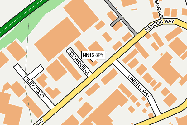
NN16 8PY is located in the Northall electoral ward, within the unitary authority of North Northamptonshire and the English Parliamentary constituency of Kettering. The Sub Integrated Care Board (ICB) Location is NHS Northamptonshire ICB - 78H and the police force is Northamptonshire. This postcode has been in use since February 1990.


GetTheData
Source: OS OpenMap – Local (Ordnance Survey)
Source: OS VectorMap District (Ordnance Survey)
Licence: Open Government Licence (requires attribution)
| Easting | 485654 |
| Northing | 279921 |
| Latitude | 52.410596 |
| Longitude | -0.742203 |
GetTheData
Source: Open Postcode Geo
Licence: Open Government Licence
| Country | England |
| Postcode District | NN16 |
➜ See where NN16 is on a map ➜ Where is Kettering? | |
GetTheData
Source: Land Registry Price Paid Data
Licence: Open Government Licence
Elevation or altitude of NN16 8PY as distance above sea level:
| Metres | Feet | |
|---|---|---|
| Elevation | 100m | 328ft |
Elevation is measured from the approximate centre of the postcode, to the nearest point on an OS contour line from OS Terrain 50, which has contour spacing of ten vertical metres.
➜ How high above sea level am I? Find the elevation of your current position using your device's GPS.
GetTheData
Source: Open Postcode Elevation
Licence: Open Government Licence
| Ward | Northall |
| Constituency | Kettering |
GetTheData
Source: ONS Postcode Database
Licence: Open Government Licence
| Linnell Way (Henson Way) | Kettering | 57m |
| Linnell Way (Henson Way) | Kettering | 116m |
| Riley Road (Henson Way) | Kettering | 140m |
| Riley Road (Henson Way) | Kettering | 209m |
| Enterprise Close (Telford Way) | Kettering | 243m |
| Kettering Station | 2km |
GetTheData
Source: NaPTAN
Licence: Open Government Licence
Estimated total energy consumption in NN16 8PY by fuel type, 2015.
| Consumption (kWh) | 130,838 |
|---|---|
| Meter count | 8 |
| Mean (kWh/meter) | 16,355 |
| Median (kWh/meter) | 7,561 |
GetTheData
Source: Postcode level gas estimates: 2015 (experimental)
Source: Postcode level electricity estimates: 2015 (experimental)
Licence: Open Government Licence
GetTheData
Source: ONS Postcode Database
Licence: Open Government Licence

➜ Get more ratings from the Food Standards Agency
GetTheData
Source: Food Standards Agency
Licence: FSA terms & conditions
| Last Collection | |||
|---|---|---|---|
| Location | Mon-Fri | Sat | Distance |
| Highfield Road | 17:00 | 11:30 | 768m |
| Carter Ave | 16:30 | 08:30 | 1,141m |
| Neale Avenue Tso | 17:15 | 11:30 | 1,175m |
GetTheData
Source: Dracos
Licence: Creative Commons Attribution-ShareAlike
The below table lists the International Territorial Level (ITL) codes (formerly Nomenclature of Territorial Units for Statistics (NUTS) codes) and Local Administrative Units (LAU) codes for NN16 8PY:
| ITL 1 Code | Name |
|---|---|
| TLF | East Midlands (England) |
| ITL 2 Code | Name |
| TLF2 | Leicestershire, Rutland and Northamptonshire |
| ITL 3 Code | Name |
| TLF25 | North Northamptonshire |
| LAU 1 Code | Name |
| E07000153 | Kettering |
GetTheData
Source: ONS Postcode Directory
Licence: Open Government Licence
The below table lists the Census Output Area (OA), Lower Layer Super Output Area (LSOA), and Middle Layer Super Output Area (MSOA) for NN16 8PY:
| Code | Name | |
|---|---|---|
| OA | E00137945 | |
| LSOA | E01027117 | Kettering 007F |
| MSOA | E02005645 | Kettering 007 |
GetTheData
Source: ONS Postcode Directory
Licence: Open Government Licence
| NN16 8PX | Henson Way | 40m |
| NN16 8UN | Telford Way | 194m |
| NN16 8SN | Telford Way | 296m |
| NN16 8PZ | Henson Close | 300m |
| NN16 9FT | Tailby Avenue | 607m |
| NN16 9FS | Malham Drive | 622m |
| NN16 9QJ | Cunliffe Drive | 634m |
| NN16 8TD | Garrard Way | 677m |
| NN16 9QQ | Brunel Close | 697m |
| NN16 9JL | Thames Rise | 716m |
GetTheData
Source: Open Postcode Geo; Land Registry Price Paid Data
Licence: Open Government Licence