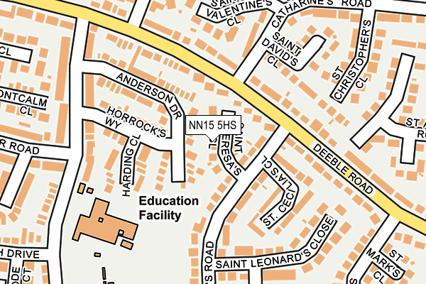
NN15 5HS lies on St Theresas Close in Kettering. NN15 5HS is located in the Ise electoral ward, within the unitary authority of North Northamptonshire and the English Parliamentary constituency of Kettering. The Sub Integrated Care Board (ICB) Location is NHS Northamptonshire ICB - 78H and the police force is Northamptonshire. This postcode has been in use since January 1980.


GetTheData
Source: OS OpenMap – Local (Ordnance Survey)
Source: OS VectorMap District (Ordnance Survey)
Licence: Open Government Licence (requires attribution)
| Easting | 488851 |
| Northing | 278241 |
| Latitude | 52.394988 |
| Longitude | -0.695661 |
GetTheData
Source: Open Postcode Geo
Licence: Open Government Licence
| Street | St Theresas Close |
| Town/City | Kettering |
| Country | England |
| Postcode District | NN15 |
➜ See where NN15 is on a map ➜ Where is Kettering? | |
GetTheData
Source: Land Registry Price Paid Data
Licence: Open Government Licence
Elevation or altitude of NN15 5HS as distance above sea level:
| Metres | Feet | |
|---|---|---|
| Elevation | 80m | 262ft |
Elevation is measured from the approximate centre of the postcode, to the nearest point on an OS contour line from OS Terrain 50, which has contour spacing of ten vertical metres.
➜ How high above sea level am I? Find the elevation of your current position using your device's GPS.
GetTheData
Source: Open Postcode Elevation
Licence: Open Government Licence
| Ward | Ise |
| Constituency | Kettering |
GetTheData
Source: ONS Postcode Database
Licence: Open Government Licence
| St David's Close (St Catharine's Road) | Kettering | 119m |
| Churchill Way (Deeble Road) | Kettering | 314m |
| St Christopher's Close (St Catharine's Road) | Kettering | 332m |
| Carisbrooke Close (St Johns Road) | Kettering | 380m |
| Carisbrooke Close (St Johns Road) | Kettering | 390m |
| Kettering Station | 2.4km |
GetTheData
Source: NaPTAN
Licence: Open Government Licence
| Percentage of properties with Next Generation Access | 100.0% |
| Percentage of properties with Superfast Broadband | 100.0% |
| Percentage of properties with Ultrafast Broadband | 0.0% |
| Percentage of properties with Full Fibre Broadband | 0.0% |
Superfast Broadband is between 30Mbps and 300Mbps
Ultrafast Broadband is > 300Mbps
| Median download speed | 62.3Mbps |
| Average download speed | 72.1Mbps |
| Maximum download speed | 150.00Mbps |
| Median upload speed | 13.6Mbps |
| Average upload speed | 12.1Mbps |
| Maximum upload speed | 19.53Mbps |
| Percentage of properties unable to receive 2Mbps | 0.0% |
| Percentage of properties unable to receive 5Mbps | 0.0% |
| Percentage of properties unable to receive 10Mbps | 0.0% |
| Percentage of properties unable to receive 30Mbps | 0.0% |
GetTheData
Source: Ofcom
Licence: Ofcom Terms of Use (requires attribution)
Estimated total energy consumption in NN15 5HS by fuel type, 2015.
| Consumption (kWh) | 255,432 |
|---|---|
| Meter count | 18 |
| Mean (kWh/meter) | 14,191 |
| Median (kWh/meter) | 13,134 |
| Consumption (kWh) | 56,923 |
|---|---|
| Meter count | 13 |
| Mean (kWh/meter) | 4,379 |
| Median (kWh/meter) | 4,499 |
GetTheData
Source: Postcode level gas estimates: 2015 (experimental)
Source: Postcode level electricity estimates: 2015 (experimental)
Licence: Open Government Licence
GetTheData
Source: ONS Postcode Database
Licence: Open Government Licence


➜ Get more ratings from the Food Standards Agency
GetTheData
Source: Food Standards Agency
Licence: FSA terms & conditions
| Last Collection | |||
|---|---|---|---|
| Location | Mon-Fri | Sat | Distance |
| St Johns Road | 17:15 | 11:30 | 480m |
| Barton Seagrave Tso | 17:30 | 11:00 | 1,125m |
| St Marys Road | 17:15 | 11:30 | 1,302m |
GetTheData
Source: Dracos
Licence: Creative Commons Attribution-ShareAlike
The below table lists the International Territorial Level (ITL) codes (formerly Nomenclature of Territorial Units for Statistics (NUTS) codes) and Local Administrative Units (LAU) codes for NN15 5HS:
| ITL 1 Code | Name |
|---|---|
| TLF | East Midlands (England) |
| ITL 2 Code | Name |
| TLF2 | Leicestershire, Rutland and Northamptonshire |
| ITL 3 Code | Name |
| TLF25 | North Northamptonshire |
| LAU 1 Code | Name |
| E07000153 | Kettering |
GetTheData
Source: ONS Postcode Directory
Licence: Open Government Licence
The below table lists the Census Output Area (OA), Lower Layer Super Output Area (LSOA), and Middle Layer Super Output Area (MSOA) for NN15 5HS:
| Code | Name | |
|---|---|---|
| OA | E00137837 | |
| LSOA | E01027098 | Kettering 008C |
| MSOA | E02005646 | Kettering 008 |
GetTheData
Source: ONS Postcode Directory
Licence: Open Government Licence
| NN15 5HW | Deeble Road | 82m |
| NN15 5DG | Anderson Drive | 85m |
| NN15 5HT | St Anthonys Road | 97m |
| NN15 5DQ | Harding Close | 109m |
| NN15 5HX | St Cecilias Close | 114m |
| NN15 5HL | Deeble Road | 130m |
| NN15 5DH | Horrocks Way | 135m |
| NN15 5ED | St Davids Close | 177m |
| NN15 5HY | St Leonards Close | 183m |
| NN15 5EG | St Valentines Close | 195m |
GetTheData
Source: Open Postcode Geo; Land Registry Price Paid Data
Licence: Open Government Licence