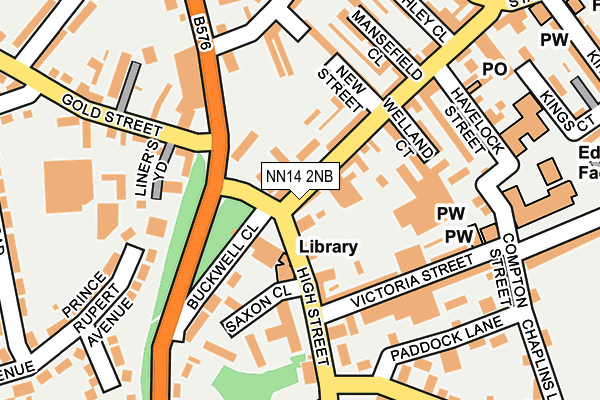
NN14 2NB lies on High Street in Desborough, Kettering. NN14 2NB is located in the Desborough electoral ward, within the unitary authority of North Northamptonshire and the English Parliamentary constituency of Kettering. The Sub Integrated Care Board (ICB) Location is NHS Northamptonshire ICB - 78H and the police force is Northamptonshire. This postcode has been in use since January 1980.


GetTheData
Source: OS OpenMap – Local (Ordnance Survey)
Source: OS VectorMap District (Ordnance Survey)
Licence: Open Government Licence (requires attribution)
| Easting | 480232 |
| Northing | 283315 |
| Latitude | 52.441939 |
| Longitude | -0.821067 |
GetTheData
Source: Open Postcode Geo
Licence: Open Government Licence
| Street | High Street |
| Locality | Desborough |
| Town/City | Kettering |
| Country | England |
| Postcode District | NN14 |
➜ See where NN14 is on a map ➜ Where is Desborough? | |
GetTheData
Source: Land Registry Price Paid Data
Licence: Open Government Licence
Elevation or altitude of NN14 2NB as distance above sea level:
| Metres | Feet | |
|---|---|---|
| Elevation | 120m | 394ft |
Elevation is measured from the approximate centre of the postcode, to the nearest point on an OS contour line from OS Terrain 50, which has contour spacing of ten vertical metres.
➜ How high above sea level am I? Find the elevation of your current position using your device's GPS.
GetTheData
Source: Open Postcode Elevation
Licence: Open Government Licence
| Ward | Desborough |
| Constituency | Kettering |
GetTheData
Source: ONS Postcode Database
Licence: Open Government Licence
| Station Road (High Street) | Desborough | 29m |
| Station Road (High Street) | Desborough | 36m |
| Paddock Lane (Lower Street) | Desborough | 210m |
| Paddock Lane (Dunkirk Avenue) | Desborough | 214m |
| Harrington Road (Gold Street) | Desborough | 249m |
GetTheData
Source: NaPTAN
Licence: Open Government Licence
| Percentage of properties with Next Generation Access | 100.0% |
| Percentage of properties with Superfast Broadband | 100.0% |
| Percentage of properties with Ultrafast Broadband | 0.0% |
| Percentage of properties with Full Fibre Broadband | 0.0% |
Superfast Broadband is between 30Mbps and 300Mbps
Ultrafast Broadband is > 300Mbps
| Percentage of properties unable to receive 2Mbps | 0.0% |
| Percentage of properties unable to receive 5Mbps | 0.0% |
| Percentage of properties unable to receive 10Mbps | 0.0% |
| Percentage of properties unable to receive 30Mbps | 0.0% |
GetTheData
Source: Ofcom
Licence: Ofcom Terms of Use (requires attribution)
GetTheData
Source: ONS Postcode Database
Licence: Open Government Licence


➜ Get more ratings from the Food Standards Agency
GetTheData
Source: Food Standards Agency
Licence: FSA terms & conditions
| Last Collection | |||
|---|---|---|---|
| Location | Mon-Fri | Sat | Distance |
| Braybrooke Road | 16:00 | 08:30 | 208m |
| Harrington Road | 16:00 | 08:45 | 316m |
| Dunkirk Avenue | 16:00 | 08:30 | 825m |
GetTheData
Source: Dracos
Licence: Creative Commons Attribution-ShareAlike
The below table lists the International Territorial Level (ITL) codes (formerly Nomenclature of Territorial Units for Statistics (NUTS) codes) and Local Administrative Units (LAU) codes for NN14 2NB:
| ITL 1 Code | Name |
|---|---|
| TLF | East Midlands (England) |
| ITL 2 Code | Name |
| TLF2 | Leicestershire, Rutland and Northamptonshire |
| ITL 3 Code | Name |
| TLF25 | North Northamptonshire |
| LAU 1 Code | Name |
| E07000153 | Kettering |
GetTheData
Source: ONS Postcode Directory
Licence: Open Government Licence
The below table lists the Census Output Area (OA), Lower Layer Super Output Area (LSOA), and Middle Layer Super Output Area (MSOA) for NN14 2NB:
| Code | Name | |
|---|---|---|
| OA | E00137827 | |
| LSOA | E01032971 | Kettering 002I |
| MSOA | E02005640 | Kettering 002 |
GetTheData
Source: ONS Postcode Directory
Licence: Open Government Licence
| NN14 2ND | High Street | 44m |
| NN14 2RL | Station Road | 105m |
| NN14 2LX | Victoria Street | 123m |
| NN14 2QZ | New Street | 157m |
| NN14 2PQ | Welland Court | 158m |
| NN14 2NA | High Street | 159m |
| NN14 2LU | Havelock Street | 176m |
| NN14 2NQ | Gold Street | 183m |
| NN14 2PD | Buckwell Close | 193m |
| NN14 2RA | Mansefield Close | 198m |
GetTheData
Source: Open Postcode Geo; Land Registry Price Paid Data
Licence: Open Government Licence