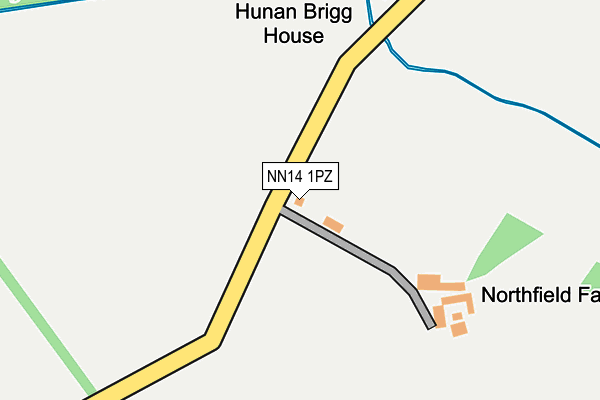
NN14 1PZ lies on Northfield Road in Cransley, Kettering. NN14 1PZ is located in the Rothwell and Mawsley electoral ward, within the unitary authority of North Northamptonshire and the English Parliamentary constituency of Kettering. The Sub Integrated Care Board (ICB) Location is NHS Northamptonshire ICB - 78H and the police force is Northamptonshire. This postcode has been in use since January 1980.


GetTheData
Source: OS OpenMap – Local (Ordnance Survey)
Source: OS VectorMap District (Ordnance Survey)
Licence: Open Government Licence (requires attribution)
| Easting | 484577 |
| Northing | 278657 |
| Latitude | 52.399403 |
| Longitude | -0.758351 |
GetTheData
Source: Open Postcode Geo
Licence: Open Government Licence
| Street | Northfield Road |
| Locality | Cransley |
| Town/City | Kettering |
| Country | England |
| Postcode District | NN14 |
➜ See where NN14 is on a map | |
GetTheData
Source: Land Registry Price Paid Data
Licence: Open Government Licence
Elevation or altitude of NN14 1PZ as distance above sea level:
| Metres | Feet | |
|---|---|---|
| Elevation | 80m | 262ft |
Elevation is measured from the approximate centre of the postcode, to the nearest point on an OS contour line from OS Terrain 50, which has contour spacing of ten vertical metres.
➜ How high above sea level am I? Find the elevation of your current position using your device's GPS.
GetTheData
Source: Open Postcode Elevation
Licence: Open Government Licence
| Ward | Rothwell And Mawsley |
| Constituency | Kettering |
GetTheData
Source: ONS Postcode Database
Licence: Open Government Licence
| Gipsy Lane | Kettering | 914m |
| Gipsy Lane (Rothwell Road) | Kettering | 916m |
| Gipsy Lane | Kettering | 930m |
| Gipsy Lane | Kettering | 961m |
| Gipsy Lane (Warren Hill) | Kettering | 988m |
| Kettering Station | 1.9km |
GetTheData
Source: NaPTAN
Licence: Open Government Licence
| Percentage of properties with Next Generation Access | 100.0% |
| Percentage of properties with Superfast Broadband | 16.7% |
| Percentage of properties with Ultrafast Broadband | 16.7% |
| Percentage of properties with Full Fibre Broadband | 16.7% |
Superfast Broadband is between 30Mbps and 300Mbps
Ultrafast Broadband is > 300Mbps
| Percentage of properties unable to receive 2Mbps | 0.0% |
| Percentage of properties unable to receive 5Mbps | 16.7% |
| Percentage of properties unable to receive 10Mbps | 50.0% |
| Percentage of properties unable to receive 30Mbps | 83.3% |
GetTheData
Source: Ofcom
Licence: Ofcom Terms of Use (requires attribution)
GetTheData
Source: ONS Postcode Database
Licence: Open Government Licence


➜ Get more ratings from the Food Standards Agency
GetTheData
Source: Food Standards Agency
Licence: FSA terms & conditions
| Last Collection | |||
|---|---|---|---|
| Location | Mon-Fri | Sat | Distance |
| Highfield Road | 17:00 | 11:30 | 1,148m |
| Lake Avenue | 16:00 | 11:00 | 1,204m |
| Carter Ave | 16:30 | 08:30 | 1,630m |
GetTheData
Source: Dracos
Licence: Creative Commons Attribution-ShareAlike
The below table lists the International Territorial Level (ITL) codes (formerly Nomenclature of Territorial Units for Statistics (NUTS) codes) and Local Administrative Units (LAU) codes for NN14 1PZ:
| ITL 1 Code | Name |
|---|---|
| TLF | East Midlands (England) |
| ITL 2 Code | Name |
| TLF2 | Leicestershire, Rutland and Northamptonshire |
| ITL 3 Code | Name |
| TLF25 | North Northamptonshire |
| LAU 1 Code | Name |
| E07000153 | Kettering |
GetTheData
Source: ONS Postcode Directory
Licence: Open Government Licence
The below table lists the Census Output Area (OA), Lower Layer Super Output Area (LSOA), and Middle Layer Super Output Area (MSOA) for NN14 1PZ:
| Code | Name | |
|---|---|---|
| OA | E00169214 | |
| LSOA | E01032972 | Kettering 011G |
| MSOA | E02005649 | Kettering 011 |
GetTheData
Source: ONS Postcode Directory
Licence: Open Government Licence
| NN16 8TW | Thorpe Lane | 456m |
| NN16 8UB | Gipsy Lane | 862m |
| NN16 8LZ | Buttermere Close | 878m |
| NN15 7LR | Hall Lane | 886m |
| NN16 8LE | Langsett Close | 891m |
| NN16 8UD | Ullswater Road | 909m |
| NN16 8US | Winterburn Court | 929m |
| NN16 8LT | Haweswater Road | 934m |
| NN16 8LY | Thirlmere Close | 947m |
| NN16 8LS | Carsington Close | 976m |
GetTheData
Source: Open Postcode Geo; Land Registry Price Paid Data
Licence: Open Government Licence