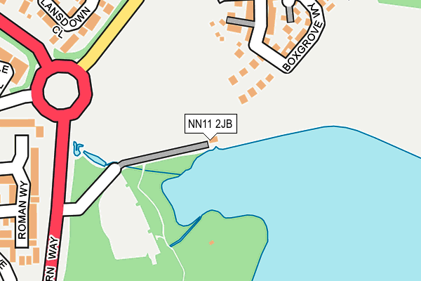
NN11 2JB is located in the Daventry East electoral ward, within the unitary authority of West Northamptonshire and the English Parliamentary constituency of Daventry. The Sub Integrated Care Board (ICB) Location is NHS Northamptonshire ICB - 78H and the police force is Northamptonshire. This postcode has been in use since September 2004.


GetTheData
Source: OS OpenMap – Local (Ordnance Survey)
Source: OS VectorMap District (Ordnance Survey)
Licence: Open Government Licence (requires attribution)
| Easting | 457770 |
| Northing | 264198 |
| Latitude | 52.272925 |
| Longitude | -1.154756 |
GetTheData
Source: Open Postcode Geo
Licence: Open Government Licence
| Country | England |
| Postcode District | NN11 |
➜ See where NN11 is on a map | |
GetTheData
Source: Land Registry Price Paid Data
Licence: Open Government Licence
Elevation or altitude of NN11 2JB as distance above sea level:
| Metres | Feet | |
|---|---|---|
| Elevation | 120m | 394ft |
Elevation is measured from the approximate centre of the postcode, to the nearest point on an OS contour line from OS Terrain 50, which has contour spacing of ten vertical metres.
➜ How high above sea level am I? Find the elevation of your current position using your device's GPS.
GetTheData
Source: Open Postcode Elevation
Licence: Open Government Licence
| Ward | Daventry East |
| Constituency | Daventry |
GetTheData
Source: ONS Postcode Database
Licence: Open Government Licence
| Country Park (Northern Way) | Daventry | 227m |
| Marston Way (Welton Lane) | Daventry | 263m |
| Wimbourne Place (Speke Drive) | Daventry | 353m |
| Nantwich Drive (Marston Way) | Daventry | 358m |
| Poplar Close (Speke Drive) | Daventry | 466m |
| Long Buckby Station | 5.3km |
GetTheData
Source: NaPTAN
Licence: Open Government Licence
GetTheData
Source: ONS Postcode Database
Licence: Open Government Licence


➜ Get more ratings from the Food Standards Agency
GetTheData
Source: Food Standards Agency
Licence: FSA terms & conditions
| Last Collection | |||
|---|---|---|---|
| Location | Mon-Fri | Sat | Distance |
| Churchill Road | 16:00 | 09:30 | 1,561m |
| Kiln Lane | 16:00 | 09:00 | 1,650m |
| Prospect Way | 18:30 | 2,104m | |
GetTheData
Source: Dracos
Licence: Creative Commons Attribution-ShareAlike
The below table lists the International Territorial Level (ITL) codes (formerly Nomenclature of Territorial Units for Statistics (NUTS) codes) and Local Administrative Units (LAU) codes for NN11 2JB:
| ITL 1 Code | Name |
|---|---|
| TLF | East Midlands (England) |
| ITL 2 Code | Name |
| TLF2 | Leicestershire, Rutland and Northamptonshire |
| ITL 3 Code | Name |
| TLF24 | West Northamptonshire |
| LAU 1 Code | Name |
| E07000151 | Daventry |
GetTheData
Source: ONS Postcode Directory
Licence: Open Government Licence
The below table lists the Census Output Area (OA), Lower Layer Super Output Area (LSOA), and Middle Layer Super Output Area (MSOA) for NN11 2JB:
| Code | Name | |
|---|---|---|
| OA | E00137387 | |
| LSOA | E01027012 | Daventry 006D |
| MSOA | E02005624 | Daventry 006 |
GetTheData
Source: ONS Postcode Directory
Licence: Open Government Licence
| NN11 2NY | Cartmel Road | 208m |
| NN11 2PA | Cleeve Close | 267m |
| NN11 0GP | Lansdown Close | 271m |
| NN11 2NX | Battle Avenue | 285m |
| NN11 0GN | Stafford Close | 318m |
| NN11 0RW | Roman Way | 320m |
| NN11 0XY | Wimborne Place | 345m |
| NN11 2NZ | Castle Acre | 349m |
| NN11 2NP | Buckfast Close | 357m |
| NN11 2LA | St Olave Close | 367m |
GetTheData
Source: Open Postcode Geo; Land Registry Price Paid Data
Licence: Open Government Licence