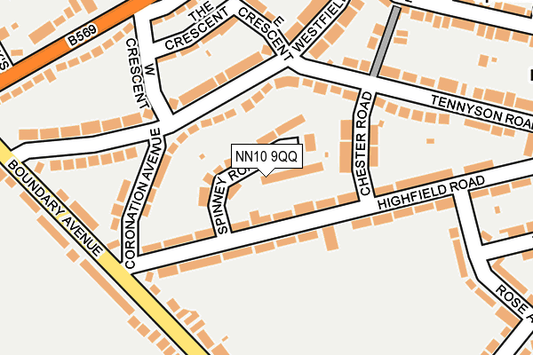
NN10 9QQ lies on Spinney Road in Rushden. NN10 9QQ is located in the Rushden Pemberton West electoral ward, within the unitary authority of North Northamptonshire and the English Parliamentary constituency of Wellingborough. The Sub Integrated Care Board (ICB) Location is NHS Northamptonshire ICB - 78H and the police force is Northamptonshire. This postcode has been in use since January 1980.


GetTheData
Source: OS OpenMap – Local (Ordnance Survey)
Source: OS VectorMap District (Ordnance Survey)
Licence: Open Government Licence (requires attribution)
| Easting | 494560 |
| Northing | 266498 |
| Latitude | 52.288492 |
| Longitude | -0.615088 |
GetTheData
Source: Open Postcode Geo
Licence: Open Government Licence
| Street | Spinney Road |
| Town/City | Rushden |
| Country | England |
| Postcode District | NN10 |
➜ See where NN10 is on a map ➜ Where is Rushden? | |
GetTheData
Source: Land Registry Price Paid Data
Licence: Open Government Licence
Elevation or altitude of NN10 9QQ as distance above sea level:
| Metres | Feet | |
|---|---|---|
| Elevation | 80m | 262ft |
Elevation is measured from the approximate centre of the postcode, to the nearest point on an OS contour line from OS Terrain 50, which has contour spacing of ten vertical metres.
➜ How high above sea level am I? Find the elevation of your current position using your device's GPS.
GetTheData
Source: Open Postcode Elevation
Licence: Open Government Licence
| Ward | Rushden Pemberton West |
| Constituency | Wellingborough |
GetTheData
Source: ONS Postcode Database
Licence: Open Government Licence
| Spinney Road (Highfield Road) | Rushden | 56m |
| West Crescent (Westfield Avenue) | Rushden | 101m |
| West Crescent (Westfield Avenue) | Rushden | 114m |
| Coronation Avenue | Rushden | 143m |
| The Crescent (West Crescent) | Rushden | 174m |
| Wellingborough Station | 4.5km |
GetTheData
Source: NaPTAN
Licence: Open Government Licence
| Percentage of properties with Next Generation Access | 100.0% |
| Percentage of properties with Superfast Broadband | 100.0% |
| Percentage of properties with Ultrafast Broadband | 97.8% |
| Percentage of properties with Full Fibre Broadband | 0.0% |
Superfast Broadband is between 30Mbps and 300Mbps
Ultrafast Broadband is > 300Mbps
| Median download speed | 34.3Mbps |
| Average download speed | 58.4Mbps |
| Maximum download speed | 350.00Mbps |
| Median upload speed | 5.7Mbps |
| Average upload speed | 4.1Mbps |
| Maximum upload speed | 9.27Mbps |
| Percentage of properties unable to receive 2Mbps | 0.0% |
| Percentage of properties unable to receive 5Mbps | 0.0% |
| Percentage of properties unable to receive 10Mbps | 0.0% |
| Percentage of properties unable to receive 30Mbps | 0.0% |
GetTheData
Source: Ofcom
Licence: Ofcom Terms of Use (requires attribution)
Estimated total energy consumption in NN10 9QQ by fuel type, 2015.
| Consumption (kWh) | 189,532 |
|---|---|
| Meter count | 16 |
| Mean (kWh/meter) | 11,846 |
| Median (kWh/meter) | 11,012 |
| Consumption (kWh) | 221,290 |
|---|---|
| Meter count | 46 |
| Mean (kWh/meter) | 4,811 |
| Median (kWh/meter) | 4,880 |
GetTheData
Source: Postcode level gas estimates: 2015 (experimental)
Source: Postcode level electricity estimates: 2015 (experimental)
Licence: Open Government Licence
GetTheData
Source: ONS Postcode Database
Licence: Open Government Licence


➜ Get more ratings from the Food Standards Agency
GetTheData
Source: Food Standards Agency
Licence: FSA terms & conditions
| Last Collection | |||
|---|---|---|---|
| Location | Mon-Fri | Sat | Distance |
| Irchester Road | 17:15 | 11:00 | 253m |
| Birchall Road | 17:15 | 11:00 | 256m |
| Highfield Road | 17:15 | 11:00 | 576m |
GetTheData
Source: Dracos
Licence: Creative Commons Attribution-ShareAlike
The below table lists the International Territorial Level (ITL) codes (formerly Nomenclature of Territorial Units for Statistics (NUTS) codes) and Local Administrative Units (LAU) codes for NN10 9QQ:
| ITL 1 Code | Name |
|---|---|
| TLF | East Midlands (England) |
| ITL 2 Code | Name |
| TLF2 | Leicestershire, Rutland and Northamptonshire |
| ITL 3 Code | Name |
| TLF25 | North Northamptonshire |
| LAU 1 Code | Name |
| E07000152 | East Northamptonshire |
GetTheData
Source: ONS Postcode Directory
Licence: Open Government Licence
The below table lists the Census Output Area (OA), Lower Layer Super Output Area (LSOA), and Middle Layer Super Output Area (MSOA) for NN10 9QQ:
| Code | Name | |
|---|---|---|
| OA | E00137708 | |
| LSOA | E01027072 | East Northamptonshire 008E |
| MSOA | E02005636 | East Northamptonshire 008 |
GetTheData
Source: ONS Postcode Directory
Licence: Open Government Licence
| NN10 9QL | Highfield Road | 52m |
| NN10 9QN | Highfield Road | 97m |
| NN10 9QG | Chester Road | 98m |
| NN10 9RD | Westfield Avenue | 121m |
| NN10 9QP | Coronation Avenue | 133m |
| NN10 9QZ | The Crescent | 171m |
| NN10 9QF | Tennyson Road | 185m |
| NN10 9RA | West Crescent | 186m |
| NN10 9QY | East Crescent | 194m |
| NN10 9QJ | Highfield Road | 194m |
GetTheData
Source: Open Postcode Geo; Land Registry Price Paid Data
Licence: Open Government Licence