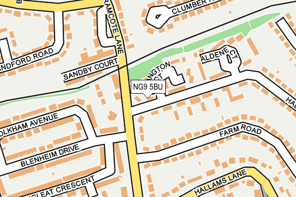
NG9 5BU lies on Hall Drive in Beeston, Nottingham. NG9 5BU is located in the Attenborough & Chilwell East electoral ward, within the local authority district of Broxtowe and the English Parliamentary constituency of Broxtowe. The Sub Integrated Care Board (ICB) Location is NHS Nottingham and Nottinghamshire ICB - 52R and the police force is Nottinghamshire. This postcode has been in use since January 1980.


GetTheData
Source: OS OpenMap – Local (Ordnance Survey)
Source: OS VectorMap District (Ordnance Survey)
Licence: Open Government Licence (requires attribution)
| Easting | 451467 |
| Northing | 336208 |
| Latitude | 52.920831 |
| Longitude | -1.235961 |
GetTheData
Source: Open Postcode Geo
Licence: Open Government Licence
| Street | Hall Drive |
| Locality | Beeston |
| Town/City | Nottingham |
| Country | England |
| Postcode District | NG9 |
➜ See where NG9 is on a map ➜ Where is Beeston? | |
GetTheData
Source: Land Registry Price Paid Data
Licence: Open Government Licence
Elevation or altitude of NG9 5BU as distance above sea level:
| Metres | Feet | |
|---|---|---|
| Elevation | 40m | 131ft |
Elevation is measured from the approximate centre of the postcode, to the nearest point on an OS contour line from OS Terrain 50, which has contour spacing of ten vertical metres.
➜ How high above sea level am I? Find the elevation of your current position using your device's GPS.
GetTheData
Source: Open Postcode Elevation
Licence: Open Government Licence
| Ward | Attenborough & Chilwell East |
| Constituency | Broxtowe |
GetTheData
Source: ONS Postcode Database
Licence: Open Government Licence
| Hall Drive (Bramcote Lane) | Chilwell | 52m |
| Sandby Court (Bramcote Lane) | Chilwell | 178m |
| Hallams Lane (Bramcote Lane) | Chilwell | 220m |
| School Lane (Field Lane) | Chilwell | 277m |
| Blandford Road (Inham Road) | Chilwell | 289m |
| Bramcote Lane Tram Stop (Sandby Court) | Chilwell | 83m |
| Cator Lane Tram Stop (N/A) | Chilwell | 362m |
| Eskdale Drive Tram Stop (Eskdale Drive) | Chilwell | 484m |
| High Road - Central College Tram Stop (High Road) | Chilwell | 855m |
| Inham Road Tram Stop (Eskdale Drive) | Chilwell | 1,051m |
| Attenborough Station | 1.7km |
| Beeston Station | 1.9km |
| Long Eaton Station | 5.3km |
GetTheData
Source: NaPTAN
Licence: Open Government Licence
| Percentage of properties with Next Generation Access | 100.0% |
| Percentage of properties with Superfast Broadband | 100.0% |
| Percentage of properties with Ultrafast Broadband | 100.0% |
| Percentage of properties with Full Fibre Broadband | 0.0% |
Superfast Broadband is between 30Mbps and 300Mbps
Ultrafast Broadband is > 300Mbps
| Percentage of properties unable to receive 2Mbps | 0.0% |
| Percentage of properties unable to receive 5Mbps | 0.0% |
| Percentage of properties unable to receive 10Mbps | 0.0% |
| Percentage of properties unable to receive 30Mbps | 0.0% |
GetTheData
Source: Ofcom
Licence: Ofcom Terms of Use (requires attribution)
GetTheData
Source: ONS Postcode Database
Licence: Open Government Licence


➜ Get more ratings from the Food Standards Agency
GetTheData
Source: Food Standards Agency
Licence: FSA terms & conditions
| Last Collection | |||
|---|---|---|---|
| Location | Mon-Fri | Sat | Distance |
| Ingham Road | 17:00 | 11:30 | 213m |
| Blenheim Drive | 17:00 | 11:30 | 332m |
| Sunnyside Post Office | 17:00 | 11:45 | 430m |
GetTheData
Source: Dracos
Licence: Creative Commons Attribution-ShareAlike
The below table lists the International Territorial Level (ITL) codes (formerly Nomenclature of Territorial Units for Statistics (NUTS) codes) and Local Administrative Units (LAU) codes for NG9 5BU:
| ITL 1 Code | Name |
|---|---|
| TLF | East Midlands (England) |
| ITL 2 Code | Name |
| TLF1 | Derbyshire and Nottinghamshire |
| ITL 3 Code | Name |
| TLF16 | South Nottinghamshire |
| LAU 1 Code | Name |
| E07000172 | Broxtowe |
GetTheData
Source: ONS Postcode Directory
Licence: Open Government Licence
The below table lists the Census Output Area (OA), Lower Layer Super Output Area (LSOA), and Middle Layer Super Output Area (MSOA) for NG9 5BU:
| Code | Name | |
|---|---|---|
| OA | E00143153 | |
| LSOA | E01028095 | Broxtowe 014D |
| MSOA | E02005863 | Broxtowe 014 |
GetTheData
Source: ONS Postcode Directory
Licence: Open Government Licence
| NG9 5BT | Babington Court | 47m |
| NG9 5EF | Brook Chase Mews | 71m |
| NG9 5EN | Bramcote Lane | 85m |
| NG9 5BW | Hall Drive | 107m |
| NG9 5DA | Farm Road | 121m |
| NG9 4ER | Sandby Court | 147m |
| NG9 4ET | Bramcote Lane | 168m |
| NG9 5BS | Aldene Court | 191m |
| NG9 4ES | Bramcote Lane | 196m |
| NG9 5EL | Bramcote Lane | 213m |
GetTheData
Source: Open Postcode Geo; Land Registry Price Paid Data
Licence: Open Government Licence