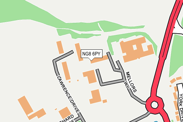
NG8 6PY lies on Mellors Way in Nottingham. NG8 6PY is located in the Bilborough electoral ward, within the unitary authority of Nottingham and the English Parliamentary constituency of Nottingham North. The Sub Integrated Care Board (ICB) Location is NHS Nottingham and Nottinghamshire ICB - 52R and the police force is Nottinghamshire. This postcode has been in use since January 2006.


GetTheData
Source: OS OpenMap – Local (Ordnance Survey)
Source: OS VectorMap District (Ordnance Survey)
Licence: Open Government Licence (requires attribution)
| Easting | 451250 |
| Northing | 342951 |
| Latitude | 52.981460 |
| Longitude | -1.238124 |
GetTheData
Source: Open Postcode Geo
Licence: Open Government Licence
| Street | Mellors Way |
| Town/City | Nottingham |
| Country | England |
| Postcode District | NG8 |
➜ See where NG8 is on a map ➜ Where is Nottingham? | |
GetTheData
Source: Land Registry Price Paid Data
Licence: Open Government Licence
Elevation or altitude of NG8 6PY as distance above sea level:
| Metres | Feet | |
|---|---|---|
| Elevation | 110m | 361ft |
Elevation is measured from the approximate centre of the postcode, to the nearest point on an OS contour line from OS Terrain 50, which has contour spacing of ten vertical metres.
➜ How high above sea level am I? Find the elevation of your current position using your device's GPS.
GetTheData
Source: Open Postcode Elevation
Licence: Open Government Licence
| Ward | Bilborough |
| Constituency | Nottingham North |
GetTheData
Source: ONS Postcode Database
Licence: Open Government Licence
| Nottingham Business Park (Woodhouse Way) | Nottingham Business Park | 231m |
| Willesden Green (Mornington Crescent) | Assarts Farm | 452m |
| Cranwell Road | Strelley | 499m |
| Willesden Green (Mornington Crescent) | Assarts Farm | 500m |
| Cranwell Road | Strelley | 506m |
| Bulwell Station | 3.5km |
| Ilkeston Station | 3.8km |
GetTheData
Source: NaPTAN
Licence: Open Government Licence
| Median download speed | 1.5Mbps |
| Average download speed | 2.5Mbps |
| Maximum download speed | 4.81Mbps |
| Median upload speed | 0.5Mbps |
| Average upload speed | 0.6Mbps |
| Maximum upload speed | 0.96Mbps |
GetTheData
Source: Ofcom
Licence: Ofcom Terms of Use (requires attribution)
GetTheData
Source: ONS Postcode Database
Licence: Open Government Licence


➜ Get more ratings from the Food Standards Agency
GetTheData
Source: Food Standards Agency
Licence: FSA terms & conditions
| Last Collection | |||
|---|---|---|---|
| Location | Mon-Fri | Sat | Distance |
| Mornington Crescent | 17:30 | 11:00 | 321m |
| Cranwell Road | 17:00 | 11:30 | 531m |
| Moorgreen Drive | 17:30 | 12:00 | 753m |
GetTheData
Source: Dracos
Licence: Creative Commons Attribution-ShareAlike
The below table lists the International Territorial Level (ITL) codes (formerly Nomenclature of Territorial Units for Statistics (NUTS) codes) and Local Administrative Units (LAU) codes for NG8 6PY:
| ITL 1 Code | Name |
|---|---|
| TLF | East Midlands (England) |
| ITL 2 Code | Name |
| TLF1 | Derbyshire and Nottinghamshire |
| ITL 3 Code | Name |
| TLF14 | Nottingham |
| LAU 1 Code | Name |
| E06000018 | Nottingham |
GetTheData
Source: ONS Postcode Directory
Licence: Open Government Licence
The below table lists the Census Output Area (OA), Lower Layer Super Output Area (LSOA), and Middle Layer Super Output Area (MSOA) for NG8 6PY:
| Code | Name | |
|---|---|---|
| OA | E00069931 | |
| LSOA | E01013864 | Nottingham 014A |
| MSOA | E02002881 | Nottingham 014 |
GetTheData
Source: ONS Postcode Directory
Licence: Open Government Licence
| NG8 6PX | Orchard Place | 191m |
| NG8 6PP | York Drive | 318m |
| NG8 6PN | Wellesley Crescent | 360m |
| NG8 6PG | Halifax Court | 406m |
| NG16 1QF | Willesden Green | 431m |
| NG8 6PH | Lancaster Way | 447m |
| NG8 6PJ | Shackleton Close | 467m |
| NG8 6NZ | Woolsington Close | 476m |
| NG8 6NT | Cranwell Road | 477m |
| NG8 6PL | Sunderland Grove | 505m |
GetTheData
Source: Open Postcode Geo; Land Registry Price Paid Data
Licence: Open Government Licence