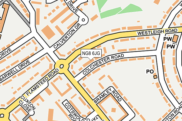
NG8 6JG is located in the Aspley electoral ward, within the unitary authority of Nottingham and the English Parliamentary constituency of Nottingham North. The Sub Integrated Care Board (ICB) Location is NHS Nottingham and Nottinghamshire ICB - 52R and the police force is Nottinghamshire. This postcode has been in use since October 2002.


GetTheData
Source: OS OpenMap – Local (Ordnance Survey)
Source: OS VectorMap District (Ordnance Survey)
Licence: Open Government Licence (requires attribution)
| Easting | 452091 |
| Northing | 342488 |
| Latitude | 52.977218 |
| Longitude | -1.225674 |
GetTheData
Source: Open Postcode Geo
Licence: Open Government Licence
| Country | England |
| Postcode District | NG8 |
➜ See where NG8 is on a map ➜ Where is Nottingham? | |
GetTheData
Source: Land Registry Price Paid Data
Licence: Open Government Licence
Elevation or altitude of NG8 6JG as distance above sea level:
| Metres | Feet | |
|---|---|---|
| Elevation | 90m | 295ft |
Elevation is measured from the approximate centre of the postcode, to the nearest point on an OS contour line from OS Terrain 50, which has contour spacing of ten vertical metres.
➜ How high above sea level am I? Find the elevation of your current position using your device's GPS.
GetTheData
Source: Open Postcode Elevation
Licence: Open Government Licence
| Ward | Aspley |
| Constituency | Nottingham North |
GetTheData
Source: ONS Postcode Database
Licence: Open Government Licence
| Westleigh Road | Broxtowe Estate | 47m |
| Westleigh Road | Broxtowe Estate | 104m |
| Calverton Drive | Strelley | 109m |
| Tangmere Crescent (Helston Drive) | Strelley | 167m |
| Strelley Club (Cranwell Road) | Strelley | 180m |
| Phoenix Park Tram Stop (Millennium Way East) | Phoenix Park | 1,810m |
| Bulwell Station | 3.2km |
| Ilkeston Station | 4.7km |
GetTheData
Source: NaPTAN
Licence: Open Government Licence
| Percentage of properties with Next Generation Access | 100.0% |
| Percentage of properties with Superfast Broadband | 100.0% |
| Percentage of properties with Ultrafast Broadband | 100.0% |
| Percentage of properties with Full Fibre Broadband | 0.0% |
Superfast Broadband is between 30Mbps and 300Mbps
Ultrafast Broadband is > 300Mbps
| Percentage of properties unable to receive 2Mbps | 0.0% |
| Percentage of properties unable to receive 5Mbps | 0.0% |
| Percentage of properties unable to receive 10Mbps | 0.0% |
| Percentage of properties unable to receive 30Mbps | 0.0% |
GetTheData
Source: Ofcom
Licence: Ofcom Terms of Use (requires attribution)
Estimated total energy consumption in NG8 6JG by fuel type, 2015.
| Consumption (kWh) | 48,347 |
|---|---|
| Meter count | 7 |
| Mean (kWh/meter) | 6,907 |
| Median (kWh/meter) | 6,309 |
GetTheData
Source: Postcode level gas estimates: 2015 (experimental)
Source: Postcode level electricity estimates: 2015 (experimental)
Licence: Open Government Licence
GetTheData
Source: ONS Postcode Database
Licence: Open Government Licence


➜ Get more ratings from the Food Standards Agency
GetTheData
Source: Food Standards Agency
Licence: FSA terms & conditions
| Last Collection | |||
|---|---|---|---|
| Location | Mon-Fri | Sat | Distance |
| Helston Drive | 17:00 | 11:30 | 85m |
| Woodfield Road Post Office | 17:00 | 11:30 | 228m |
| Moorgreen Drive | 17:30 | 12:00 | 377m |
GetTheData
Source: Dracos
Licence: Creative Commons Attribution-ShareAlike
The below table lists the International Territorial Level (ITL) codes (formerly Nomenclature of Territorial Units for Statistics (NUTS) codes) and Local Administrative Units (LAU) codes for NG8 6JG:
| ITL 1 Code | Name |
|---|---|
| TLF | East Midlands (England) |
| ITL 2 Code | Name |
| TLF1 | Derbyshire and Nottinghamshire |
| ITL 3 Code | Name |
| TLF14 | Nottingham |
| LAU 1 Code | Name |
| E06000018 | Nottingham |
GetTheData
Source: ONS Postcode Directory
Licence: Open Government Licence
The below table lists the Census Output Area (OA), Lower Layer Super Output Area (LSOA), and Middle Layer Super Output Area (MSOA) for NG8 6JG:
| Code | Name | |
|---|---|---|
| OA | E00069711 | |
| LSOA | E01013818 | Nottingham 011B |
| MSOA | E02002878 | Nottingham 011 |
GetTheData
Source: ONS Postcode Directory
Licence: Open Government Licence
| NG8 6JX | Westleigh Road | 85m |
| NG8 6LB | Colchester Road | 99m |
| NG8 6JY | Westleigh Road | 108m |
| NG8 6LA | Helston Drive | 117m |
| NG8 6LD | Bramley Road | 169m |
| NG8 6LF | Tangmere Crescent | 175m |
| NG8 6LG | Bramley Green | 177m |
| NG8 6JZ | Helston Drive | 186m |
| NG8 6LE | Cotswold Road | 197m |
| NG8 6HY | Woodfield Road | 218m |
GetTheData
Source: Open Postcode Geo; Land Registry Price Paid Data
Licence: Open Government Licence