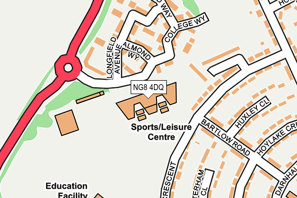
NG8 4DQ is located in the Bilborough electoral ward, within the unitary authority of Nottingham and the English Parliamentary constituency of Nottingham North. The Sub Integrated Care Board (ICB) Location is NHS Nottingham and Nottinghamshire ICB - 52R and the police force is Nottinghamshire. This postcode has been in use since January 1980.


GetTheData
Source: OS OpenMap – Local (Ordnance Survey)
Source: OS VectorMap District (Ordnance Survey)
Licence: Open Government Licence (requires attribution)
| Easting | 451527 |
| Northing | 341318 |
| Latitude | 52.966756 |
| Longitude | -1.234258 |
GetTheData
Source: Open Postcode Geo
Licence: Open Government Licence
| Country | England |
| Postcode District | NG8 |
➜ See where NG8 is on a map ➜ Where is Nottingham? | |
GetTheData
Source: Land Registry Price Paid Data
Licence: Open Government Licence
Elevation or altitude of NG8 4DQ as distance above sea level:
| Metres | Feet | |
|---|---|---|
| Elevation | 80m | 262ft |
Elevation is measured from the approximate centre of the postcode, to the nearest point on an OS contour line from OS Terrain 50, which has contour spacing of ten vertical metres.
➜ How high above sea level am I? Find the elevation of your current position using your device's GPS.
GetTheData
Source: Open Postcode Elevation
Licence: Open Government Licence
| Ward | Bilborough |
| Constituency | Nottingham North |
GetTheData
Source: ONS Postcode Database
Licence: Open Government Licence
| Bilborough College | Bilborough College | 94m |
| College (Bilborough Road) | Bilborough | 281m |
| Cairncross Road (Melbury Road) | Bilborough | 304m |
| Melbury Road | Bilborough | 311m |
| College (Bilborough Road) | Bilborough | 313m |
| Ilkeston Station | 4.3km |
| Bulwell Station | 4.5km |
GetTheData
Source: NaPTAN
Licence: Open Government Licence
GetTheData
Source: ONS Postcode Database
Licence: Open Government Licence


➜ Get more ratings from the Food Standards Agency
GetTheData
Source: Food Standards Agency
Licence: FSA terms & conditions
| Last Collection | |||
|---|---|---|---|
| Location | Mon-Fri | Sat | Distance |
| College Way | 17:30 | 10:30 | 100m |
| Bracebridge Drive P O | 17:00 | 11:30 | 448m |
| Fairnley Road | 17:15 | 11:30 | 536m |
GetTheData
Source: Dracos
Licence: Creative Commons Attribution-ShareAlike
The below table lists the International Territorial Level (ITL) codes (formerly Nomenclature of Territorial Units for Statistics (NUTS) codes) and Local Administrative Units (LAU) codes for NG8 4DQ:
| ITL 1 Code | Name |
|---|---|
| TLF | East Midlands (England) |
| ITL 2 Code | Name |
| TLF1 | Derbyshire and Nottinghamshire |
| ITL 3 Code | Name |
| TLF14 | Nottingham |
| LAU 1 Code | Name |
| E06000018 | Nottingham |
GetTheData
Source: ONS Postcode Directory
Licence: Open Government Licence
The below table lists the Census Output Area (OA), Lower Layer Super Output Area (LSOA), and Middle Layer Super Output Area (MSOA) for NG8 4DQ:
| Code | Name | |
|---|---|---|
| OA | E00069909 | |
| LSOA | E01013858 | Nottingham 025A |
| MSOA | E02002892 | Nottingham 025 |
GetTheData
Source: ONS Postcode Directory
Licence: Open Government Licence
| NG8 4BG | Hanslope Crescent | 105m |
| NG8 4JH | College Way | 106m |
| NG8 4JT | Almond Way | 111m |
| NG8 4JN | Spring Gardens | 135m |
| NG8 4JL | Redwood Close | 135m |
| NG8 4BD | Hanslope Crescent | 150m |
| NG8 4JP | Longfield Avenue | 151m |
| NG8 4JR | Greenwood Gardens | 153m |
| NG8 4BL | White Lodge Gardens | 155m |
| NG8 4PR | Caterham Close | 172m |
GetTheData
Source: Open Postcode Geo; Land Registry Price Paid Data
Licence: Open Government Licence
| Bracebridge Drive ( Service Road ) | At Any Time | 426m |
| Bracebridge Drive (Service Road) | At Any Time | 442m |
| Bracebridge Drive (Service Road) | At Any Time | 461m |
GetTheData
Source: Disabled parking spaces, Nottingham City Council, 19/02/2013
Licence: Open Government Licence