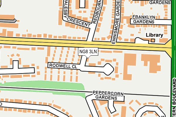
NG8 3LN lies on Radford Bridge Road in Nottingham. NG8 3LN is located in the Leen Valley electoral ward, within the unitary authority of Nottingham and the English Parliamentary constituency of Nottingham South. The Sub Integrated Care Board (ICB) Location is NHS Nottingham and Nottinghamshire ICB - 52R and the police force is Nottinghamshire. This postcode has been in use since January 1980.


GetTheData
Source: OS OpenMap – Local (Ordnance Survey)
Source: OS VectorMap District (Ordnance Survey)
Licence: Open Government Licence (requires attribution)
| Easting | 454150 |
| Northing | 340689 |
| Latitude | 52.960865 |
| Longitude | -1.195310 |
GetTheData
Source: Open Postcode Geo
Licence: Open Government Licence
| Street | Radford Bridge Road |
| Town/City | Nottingham |
| Country | England |
| Postcode District | NG8 |
➜ See where NG8 is on a map ➜ Where is Nottingham? | |
GetTheData
Source: Land Registry Price Paid Data
Licence: Open Government Licence
Elevation or altitude of NG8 3LN as distance above sea level:
| Metres | Feet | |
|---|---|---|
| Elevation | 40m | 131ft |
Elevation is measured from the approximate centre of the postcode, to the nearest point on an OS contour line from OS Terrain 50, which has contour spacing of ten vertical metres.
➜ How high above sea level am I? Find the elevation of your current position using your device's GPS.
GetTheData
Source: Open Postcode Elevation
Licence: Open Government Licence
| Ward | Leen Valley |
| Constituency | Nottingham South |
GetTheData
Source: ONS Postcode Database
Licence: Open Government Licence
| Redbourne Drive (Beechdale Road) | Beechdale | 59m |
| Redbourne Drive (Beechdale Road) | Beechdale | 61m |
| Beechdale Baths (Beechdale Road) | Beechdale | 206m |
| Beechdale Baths (Beechdale Road) | Beechdale | 216m |
| Enthorpe Street (Beechdale Road) | Beechdale | 255m |
| Wilkinson Street Tram Stop (Wilkinson Street) | Basford | 1,696m |
| Radford Road Tram Stop (Radford Road) | Forest Fields | 1,748m |
| Shipstone Street Tram Stop (Shipstone Street) | Radford | 1,890m |
| Nottingham Station | 3.6km |
| Bulwell Station | 4.3km |
| Beeston Station | 4.5km |
GetTheData
Source: NaPTAN
Licence: Open Government Licence
| Percentage of properties with Next Generation Access | 100.0% |
| Percentage of properties with Superfast Broadband | 100.0% |
| Percentage of properties with Ultrafast Broadband | 100.0% |
| Percentage of properties with Full Fibre Broadband | 0.0% |
Superfast Broadband is between 30Mbps and 300Mbps
Ultrafast Broadband is > 300Mbps
| Percentage of properties unable to receive 2Mbps | 0.0% |
| Percentage of properties unable to receive 5Mbps | 0.0% |
| Percentage of properties unable to receive 10Mbps | 0.0% |
| Percentage of properties unable to receive 30Mbps | 0.0% |
GetTheData
Source: Ofcom
Licence: Ofcom Terms of Use (requires attribution)
GetTheData
Source: ONS Postcode Database
Licence: Open Government Licence


➜ Get more ratings from the Food Standards Agency
GetTheData
Source: Food Standards Agency
Licence: FSA terms & conditions
| Last Collection | |||
|---|---|---|---|
| Location | Mon-Fri | Sat | Distance |
| Charlbury Road | 17:30 | 11:00 | 277m |
| Enthorpe Street | 17:30 | 11:00 | 320m |
| Chalfont Drive | 17:30 | 11:00 | 398m |
GetTheData
Source: Dracos
Licence: Creative Commons Attribution-ShareAlike
The below table lists the International Territorial Level (ITL) codes (formerly Nomenclature of Territorial Units for Statistics (NUTS) codes) and Local Administrative Units (LAU) codes for NG8 3LN:
| ITL 1 Code | Name |
|---|---|
| TLF | East Midlands (England) |
| ITL 2 Code | Name |
| TLF1 | Derbyshire and Nottinghamshire |
| ITL 3 Code | Name |
| TLF14 | Nottingham |
| LAU 1 Code | Name |
| E06000018 | Nottingham |
GetTheData
Source: ONS Postcode Directory
Licence: Open Government Licence
The below table lists the Census Output Area (OA), Lower Layer Super Output Area (LSOA), and Middle Layer Super Output Area (MSOA) for NG8 3LN:
| Code | Name | |
|---|---|---|
| OA | E00070301 | |
| LSOA | E01013932 | Nottingham 019C |
| MSOA | E02002886 | Nottingham 019 |
GetTheData
Source: ONS Postcode Directory
Licence: Open Government Licence
| NG8 3LP | Manville Close | 71m |
| NG8 3LQ | Rodwell Close | 83m |
| NG8 3LH | Beechdale Road | 140m |
| NG8 3LL | Beechdale Road | 141m |
| NG8 3LR | Redbourne Drive | 164m |
| NG8 3NL | Walesby Crescent | 169m |
| NG8 3LJ | Ennismore Gardens | 172m |
| NG8 1NT | Peppercorn Gardens | 194m |
| NG8 3LF | Beechdale Road | 201m |
| NG8 1NG | Charlbury Road | 207m |
GetTheData
Source: Open Postcode Geo; Land Registry Price Paid Data
Licence: Open Government Licence