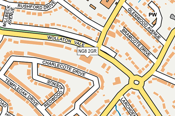
NG8 2GR is located in the Wollaton West electoral ward, within the unitary authority of Nottingham and the English Parliamentary constituency of Nottingham South. The Sub Integrated Care Board (ICB) Location is NHS Nottingham and Nottinghamshire ICB - 52R and the police force is Nottinghamshire. This postcode has been in use since January 1980.


GetTheData
Source: OS OpenMap – Local (Ordnance Survey)
Source: OS VectorMap District (Ordnance Survey)
Licence: Open Government Licence (requires attribution)
| Easting | 451778 |
| Northing | 339370 |
| Latitude | 52.949242 |
| Longitude | -1.230829 |
GetTheData
Source: Open Postcode Geo
Licence: Open Government Licence
| Country | England |
| Postcode District | NG8 |
➜ See where NG8 is on a map ➜ Where is Nottingham? | |
GetTheData
Source: Land Registry Price Paid Data
Licence: Open Government Licence
Elevation or altitude of NG8 2GR as distance above sea level:
| Metres | Feet | |
|---|---|---|
| Elevation | 50m | 164ft |
Elevation is measured from the approximate centre of the postcode, to the nearest point on an OS contour line from OS Terrain 50, which has contour spacing of ten vertical metres.
➜ How high above sea level am I? Find the elevation of your current position using your device's GPS.
GetTheData
Source: Open Postcode Elevation
Licence: Open Government Licence
| Ward | Wollaton West |
| Constituency | Nottingham South |
GetTheData
Source: ONS Postcode Database
Licence: Open Government Licence
| Arleston Drive (Wollaton Vale) | Wollaton | 54m |
| Arleston Drive (Wollaton Vale) | Wollaton | 69m |
| Hemlock Stone (Bramcote Lane) | Wollaton | 160m |
| Hemlock Stone (Bramcote Lane) | Wollaton | 174m |
| Bramcote Lane (Wollaton Vale) | Wollaton | 231m |
| Beeston Station | 3.5km |
| Attenborough Station | 4.8km |
| Ilkeston Station | 5.5km |
GetTheData
Source: NaPTAN
Licence: Open Government Licence
GetTheData
Source: ONS Postcode Database
Licence: Open Government Licence


➜ Get more ratings from the Food Standards Agency
GetTheData
Source: Food Standards Agency
Licence: FSA terms & conditions
| Last Collection | |||
|---|---|---|---|
| Location | Mon-Fri | Sat | Distance |
| Brookhill Drive | 18:00 | 12:30 | 235m |
| Fernwood Crescent | 17:00 | 12:30 | 240m |
| Bramcote Lane Post Office | 17:30 | 11:00 | 338m |
GetTheData
Source: Dracos
Licence: Creative Commons Attribution-ShareAlike
The below table lists the International Territorial Level (ITL) codes (formerly Nomenclature of Territorial Units for Statistics (NUTS) codes) and Local Administrative Units (LAU) codes for NG8 2GR:
| ITL 1 Code | Name |
|---|---|
| TLF | East Midlands (England) |
| ITL 2 Code | Name |
| TLF1 | Derbyshire and Nottinghamshire |
| ITL 3 Code | Name |
| TLF14 | Nottingham |
| LAU 1 Code | Name |
| E06000018 | Nottingham |
GetTheData
Source: ONS Postcode Directory
Licence: Open Government Licence
The below table lists the Census Output Area (OA), Lower Layer Super Output Area (LSOA), and Middle Layer Super Output Area (MSOA) for NG8 2GR:
| Code | Name | |
|---|---|---|
| OA | E00070575 | |
| LSOA | E01013984 | Nottingham 030D |
| MSOA | E02002897 | Nottingham 030 |
GetTheData
Source: ONS Postcode Directory
Licence: Open Government Licence
| NG8 2GS | Wollaton Vale | 68m |
| NG8 2SB | Charlecote Drive | 87m |
| NG8 2SD | Charlecote Drive | 103m |
| NG8 2GQ | Wollaton Vale | 114m |
| NG8 2GB | Arleston Drive | 134m |
| NG8 2NH | Bramcote Drive | 156m |
| NG8 2GE | Fernwood Crescent | 160m |
| NG8 2GP | Wollaton Vale | 165m |
| NG8 2SG | Redwood Avenue | 171m |
| NG8 2QQ | Bramcote Lane | 172m |
GetTheData
Source: Open Postcode Geo; Land Registry Price Paid Data
Licence: Open Government Licence
| Bramcote Lane | At Any Time | 304m |
| Bramcote Lane | At Any Time | 326m |
GetTheData
Source: Disabled parking spaces, Nottingham City Council, 19/02/2013
Licence: Open Government Licence