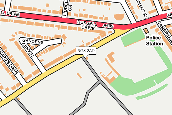
NG8 2AD is located in the Wollaton West electoral ward, within the unitary authority of Nottingham and the English Parliamentary constituency of Nottingham South. The Sub Integrated Care Board (ICB) Location is NHS Nottingham and Nottinghamshire ICB - 52R and the police force is Nottinghamshire. This postcode has been in use since January 1983.


GetTheData
Source: OS OpenMap – Local (Ordnance Survey)
Source: OS VectorMap District (Ordnance Survey)
Licence: Open Government Licence (requires attribution)
| Easting | 452973 |
| Northing | 339870 |
| Latitude | 52.953600 |
| Longitude | -1.212967 |
GetTheData
Source: Open Postcode Geo
Licence: Open Government Licence
| Country | England |
| Postcode District | NG8 |
➜ See where NG8 is on a map ➜ Where is Nottingham? | |
GetTheData
Source: Land Registry Price Paid Data
Licence: Open Government Licence
Elevation or altitude of NG8 2AD as distance above sea level:
| Metres | Feet | |
|---|---|---|
| Elevation | 50m | 164ft |
Elevation is measured from the approximate centre of the postcode, to the nearest point on an OS contour line from OS Terrain 50, which has contour spacing of ten vertical metres.
➜ How high above sea level am I? Find the elevation of your current position using your device's GPS.
GetTheData
Source: Open Postcode Elevation
Licence: Open Government Licence
| Ward | Wollaton West |
| Constituency | Nottingham South |
GetTheData
Source: ONS Postcode Database
Licence: Open Government Licence
| Wollaton Hall (Wollaton Road) | Wollaton | 86m |
| Wollaton Hall (Wollaton Road) | Wollaton | 93m |
| Wollaton Road (Russell Drive) | Wollaton | 120m |
| Old Coach Road (Wollaton Road) | Wollaton | 242m |
| St Leonards Drive (Russell Drive) | Wollaton | 290m |
| Beeston Station | 3.7km |
| Nottingham Station | 4.5km |
GetTheData
Source: NaPTAN
Licence: Open Government Licence
| Percentage of properties with Next Generation Access | 100.0% |
| Percentage of properties with Superfast Broadband | 100.0% |
| Percentage of properties with Ultrafast Broadband | 100.0% |
| Percentage of properties with Full Fibre Broadband | 100.0% |
Superfast Broadband is between 30Mbps and 300Mbps
Ultrafast Broadband is > 300Mbps
| Percentage of properties unable to receive 2Mbps | 0.0% |
| Percentage of properties unable to receive 5Mbps | 0.0% |
| Percentage of properties unable to receive 10Mbps | 0.0% |
| Percentage of properties unable to receive 30Mbps | 0.0% |
GetTheData
Source: Ofcom
Licence: Ofcom Terms of Use (requires attribution)
GetTheData
Source: ONS Postcode Database
Licence: Open Government Licence


➜ Get more ratings from the Food Standards Agency
GetTheData
Source: Food Standards Agency
Licence: FSA terms & conditions
| Last Collection | |||
|---|---|---|---|
| Location | Mon-Fri | Sat | Distance |
| Russell Drive | 17:30 | 12:30 | 108m |
| Brendon Road | 17:00 | 12:30 | 483m |
| Wollaton Village | 17:00 | 12:30 | 594m |
GetTheData
Source: Dracos
Licence: Creative Commons Attribution-ShareAlike
The below table lists the International Territorial Level (ITL) codes (formerly Nomenclature of Territorial Units for Statistics (NUTS) codes) and Local Administrative Units (LAU) codes for NG8 2AD:
| ITL 1 Code | Name |
|---|---|
| TLF | East Midlands (England) |
| ITL 2 Code | Name |
| TLF1 | Derbyshire and Nottinghamshire |
| ITL 3 Code | Name |
| TLF14 | Nottingham |
| LAU 1 Code | Name |
| E06000018 | Nottingham |
GetTheData
Source: ONS Postcode Directory
Licence: Open Government Licence
The below table lists the Census Output Area (OA), Lower Layer Super Output Area (LSOA), and Middle Layer Super Output Area (MSOA) for NG8 2AD:
| Code | Name | |
|---|---|---|
| OA | E00070561 | |
| LSOA | E01013977 | Nottingham 027A |
| MSOA | E02002894 | Nottingham 027 |
GetTheData
Source: ONS Postcode Directory
Licence: Open Government Licence
| NG8 2AA | Wollaton Road | 72m |
| NG8 2AB | Tranby Gardens | 178m |
| NG8 2BH | Russell Drive | 179m |
| NG8 2BA | Russell Drive | 183m |
| NG8 2BN | Russell Avenue | 227m |
| NG8 2BL | Russell Avenue | 237m |
| NG8 2BQ | Russell Crescent | 278m |
| NG8 1FP | Cambridge Road | 283m |
| NG8 2BP | Russell Avenue | 285m |
| NG8 2BB | St Leonards Drive | 288m |
GetTheData
Source: Open Postcode Geo; Land Registry Price Paid Data
Licence: Open Government Licence