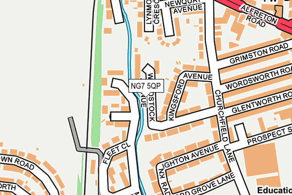
NG7 5QP lies on Woodstock Avenue in Nottingham. NG7 5QP is located in the Hyson Green & Arboretum electoral ward, within the unitary authority of Nottingham and the English Parliamentary constituency of Nottingham South. The Sub Integrated Care Board (ICB) Location is NHS Nottingham and Nottinghamshire ICB - 52R and the police force is Nottinghamshire. This postcode has been in use since January 1980.


GetTheData
Source: OS OpenMap – Local (Ordnance Survey)
Source: OS VectorMap District (Ordnance Survey)
Licence: Open Government Licence (requires attribution)
| Easting | 455028 |
| Northing | 340910 |
| Latitude | 52.962742 |
| Longitude | -1.182206 |
GetTheData
Source: Open Postcode Geo
Licence: Open Government Licence
| Street | Woodstock Avenue |
| Town/City | Nottingham |
| Country | England |
| Postcode District | NG7 |
➜ See where NG7 is on a map ➜ Where is Nottingham? | |
GetTheData
Source: Land Registry Price Paid Data
Licence: Open Government Licence
Elevation or altitude of NG7 5QP as distance above sea level:
| Metres | Feet | |
|---|---|---|
| Elevation | 40m | 131ft |
Elevation is measured from the approximate centre of the postcode, to the nearest point on an OS contour line from OS Terrain 50, which has contour spacing of ten vertical metres.
➜ How high above sea level am I? Find the elevation of your current position using your device's GPS.
GetTheData
Source: Open Postcode Elevation
Licence: Open Government Licence
| Ward | Hyson Green & Arboretum |
| Constituency | Nottingham South |
GetTheData
Source: ONS Postcode Database
Licence: Open Government Licence
| Knighton Avenue (Churchfield Lane) | Radford | 157m |
| Alfreton Road (Churchfield Lane) | Radford | 174m |
| Knighton Avenue (Churchfield Lane) | Radford | 182m |
| Alfreton Road (Churchfield Lane) | Radford | 206m |
| Chadwick Road (Alfreton Road) | Bobbers Mill | 269m |
| Hyson Green Market Tram Stop (Radford Road) | Hyson Green | 856m |
| Radford Road Tram Stop (Radford Road) | Forest Fields | 951m |
| The Forest Tram Stop (Noel Street) | The Forest | 1,039m |
| Noel Street Tram Stop (Noel Street) | Hyson Green | 1,040m |
| Wilkinson Street Tram Stop (Wilkinson Street) | Basford | 1,064m |
| Nottingham Station | 3km |
| Bulwell Station | 4.2km |
| Beeston Station | 5km |
GetTheData
Source: NaPTAN
Licence: Open Government Licence
| Percentage of properties with Next Generation Access | 100.0% |
| Percentage of properties with Superfast Broadband | 100.0% |
| Percentage of properties with Ultrafast Broadband | 100.0% |
| Percentage of properties with Full Fibre Broadband | 0.0% |
Superfast Broadband is between 30Mbps and 300Mbps
Ultrafast Broadband is > 300Mbps
| Median download speed | 50.0Mbps |
| Average download speed | 62.3Mbps |
| Maximum download speed | 200.00Mbps |
| Median upload speed | 2.0Mbps |
| Average upload speed | 7.3Mbps |
| Maximum upload speed | 20.00Mbps |
| Percentage of properties unable to receive 2Mbps | 0.0% |
| Percentage of properties unable to receive 5Mbps | 0.0% |
| Percentage of properties unable to receive 10Mbps | 0.0% |
| Percentage of properties unable to receive 30Mbps | 0.0% |
GetTheData
Source: Ofcom
Licence: Ofcom Terms of Use (requires attribution)
Estimated total energy consumption in NG7 5QP by fuel type, 2015.
| Consumption (kWh) | 506,388 |
|---|---|
| Meter count | 62 |
| Mean (kWh/meter) | 8,168 |
| Median (kWh/meter) | 6,402 |
| Consumption (kWh) | 208,724 |
|---|---|
| Meter count | 68 |
| Mean (kWh/meter) | 3,069 |
| Median (kWh/meter) | 2,313 |
GetTheData
Source: Postcode level gas estimates: 2015 (experimental)
Source: Postcode level electricity estimates: 2015 (experimental)
Licence: Open Government Licence
GetTheData
Source: ONS Postcode Database
Licence: Open Government Licence


➜ Get more ratings from the Food Standards Agency
GetTheData
Source: Food Standards Agency
Licence: FSA terms & conditions
| Last Collection | |||
|---|---|---|---|
| Location | Mon-Fri | Sat | Distance |
| Churchfield Lane | 17:00 | 12:00 | 182m |
| Bridlington Street | 17:00 | 12:00 | 393m |
| Ainsley Road | 17:30 | 11:00 | 423m |
GetTheData
Source: Dracos
Licence: Creative Commons Attribution-ShareAlike
The below table lists the International Territorial Level (ITL) codes (formerly Nomenclature of Territorial Units for Statistics (NUTS) codes) and Local Administrative Units (LAU) codes for NG7 5QP:
| ITL 1 Code | Name |
|---|---|
| TLF | East Midlands (England) |
| ITL 2 Code | Name |
| TLF1 | Derbyshire and Nottinghamshire |
| ITL 3 Code | Name |
| TLF14 | Nottingham |
| LAU 1 Code | Name |
| E06000018 | Nottingham |
GetTheData
Source: ONS Postcode Directory
Licence: Open Government Licence
The below table lists the Census Output Area (OA), Lower Layer Super Output Area (LSOA), and Middle Layer Super Output Area (MSOA) for NG7 5QP:
| Code | Name | |
|---|---|---|
| OA | E00070363 | |
| LSOA | E01013944 | Nottingham 026A |
| MSOA | E02002893 | Nottingham 026 |
GetTheData
Source: ONS Postcode Directory
Licence: Open Government Licence
| NG7 5RX | Wye Gardens | 82m |
| NG7 5QR | Kingsford Avenue | 90m |
| NG7 5RA | Truro Crescent | 140m |
| NG7 5QS | Churchfield Lane | 140m |
| NG7 5RW | Maun Avenue | 147m |
| NG7 5RU | Smite Court | 159m |
| NG7 5QD | Knighton Avenue | 161m |
| NG7 5RY | Fleet Close | 170m |
| NG7 5QA | Churchfield Lane | 186m |
| NG7 5PT | Churchfield Lane | 191m |
GetTheData
Source: Open Postcode Geo; Land Registry Price Paid Data
Licence: Open Government Licence