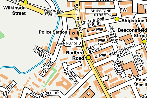
NG7 5HD is located in the Hyson Green & Arboretum electoral ward, within the unitary authority of Nottingham and the English Parliamentary constituency of Nottingham South. The Sub Integrated Care Board (ICB) Location is NHS Nottingham and Nottinghamshire ICB - 52R and the police force is Nottinghamshire. This postcode has been in use since June 1981.


GetTheData
Source: OS OpenMap – Local (Ordnance Survey)
Source: OS VectorMap District (Ordnance Survey)
Licence: Open Government Licence (requires attribution)
| Easting | 455511 |
| Northing | 341740 |
| Latitude | 52.970172 |
| Longitude | -1.174871 |
GetTheData
Source: Open Postcode Geo
Licence: Open Government Licence
| Country | England |
| Postcode District | NG7 |
➜ See where NG7 is on a map ➜ Where is Nottingham? | |
GetTheData
Source: Land Registry Price Paid Data
Licence: Open Government Licence
Elevation or altitude of NG7 5HD as distance above sea level:
| Metres | Feet | |
|---|---|---|
| Elevation | 40m | 131ft |
Elevation is measured from the approximate centre of the postcode, to the nearest point on an OS contour line from OS Terrain 50, which has contour spacing of ten vertical metres.
➜ How high above sea level am I? Find the elevation of your current position using your device's GPS.
GetTheData
Source: Open Postcode Elevation
Licence: Open Government Licence
| Ward | Hyson Green & Arboretum |
| Constituency | Nottingham South |
GetTheData
Source: ONS Postcode Database
Licence: Open Government Licence
| Bobbers Mill Road (Radford Road) | Hyson Green | 37m |
| Bobbers Mill Road (Radford Road) | Hyson Green | 68m |
| Wilkinson Street (Radford Road) | Basford | 235m |
| Radford Road (Berridge Road Central) | Hyson Green | 244m |
| Wilkinson Street | Basford | 248m |
| Radford Road Tram Stop (Radford Road) | Forest Fields | 105m |
| Shipstone Street Tram Stop (Shipstone Street) | Radford | 182m |
| Beaconsfield Street Tram Stop (Noel Street) | Forest Fields | 274m |
| Wilkinson Street Tram Stop (Wilkinson Street) | Basford | 294m |
| Hyson Green Market Tram Stop (Radford Road) | Hyson Green | 525m |
| Nottingham Station | 3.2km |
| Bulwell Station | 3.6km |
GetTheData
Source: NaPTAN
Licence: Open Government Licence
GetTheData
Source: ONS Postcode Database
Licence: Open Government Licence


➜ Get more ratings from the Food Standards Agency
GetTheData
Source: Food Standards Agency
Licence: FSA terms & conditions
| Last Collection | |||
|---|---|---|---|
| Location | Mon-Fri | Sat | Distance |
| Beaconsfield Street | 17:30 | 12:30 | 110m |
| Berridge Road | 17:30 | 12:00 | 314m |
| Bobbersmill Road | 17:00 | 12:30 | 343m |
GetTheData
Source: Dracos
Licence: Creative Commons Attribution-ShareAlike
The below table lists the International Territorial Level (ITL) codes (formerly Nomenclature of Territorial Units for Statistics (NUTS) codes) and Local Administrative Units (LAU) codes for NG7 5HD:
| ITL 1 Code | Name |
|---|---|
| TLF | East Midlands (England) |
| ITL 2 Code | Name |
| TLF1 | Derbyshire and Nottinghamshire |
| ITL 3 Code | Name |
| TLF14 | Nottingham |
| LAU 1 Code | Name |
| E06000018 | Nottingham |
GetTheData
Source: ONS Postcode Directory
Licence: Open Government Licence
The below table lists the Census Output Area (OA), Lower Layer Super Output Area (LSOA), and Middle Layer Super Output Area (MSOA) for NG7 5HD:
| Code | Name | |
|---|---|---|
| OA | E00070288 | |
| LSOA | E01013930 | Nottingham 019A |
| MSOA | E02002886 | Nottingham 019 |
GetTheData
Source: ONS Postcode Directory
Licence: Open Government Licence
| NG7 5GQ | Radford Road | 56m |
| NG7 5FY | Ashwell Gardens | 79m |
| NG7 5GP | Radford Road | 85m |
| NG7 6FZ | Goodliffe Street | 112m |
| NG7 6FY | Belton Street | 118m |
| NG7 5GR | Radford Road | 127m |
| NG7 6GA | Gladstone Street | 128m |
| NG7 6FD | Beaconsfield Street | 134m |
| NG7 5HA | The Poplars | 144m |
| NG7 5GY | Bobbers Mill Road | 159m |
GetTheData
Source: Open Postcode Geo; Land Registry Price Paid Data
Licence: Open Government Licence