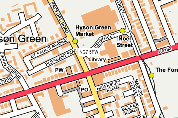
NG7 5FW lies on Radford Road in Nottingham. NG7 5FW is located in the Hyson Green & Arboretum electoral ward, within the unitary authority of Nottingham and the English Parliamentary constituency of Nottingham East. The Sub Integrated Care Board (ICB) Location is NHS Nottingham and Nottinghamshire ICB - 52R and the police force is Nottinghamshire. This postcode has been in use since January 1980.


GetTheData
Source: OS OpenMap – Local (Ordnance Survey)
Source: OS VectorMap District (Ordnance Survey)
Licence: Open Government Licence (requires attribution)
| Easting | 455828 |
| Northing | 341261 |
| Latitude | 52.965814 |
| Longitude | -1.170237 |
GetTheData
Source: Open Postcode Geo
Licence: Open Government Licence
| Street | Radford Road |
| Town/City | Nottingham |
| Country | England |
| Postcode District | NG7 |
➜ See where NG7 is on a map ➜ Where is Nottingham? | |
GetTheData
Source: Land Registry Price Paid Data
Licence: Open Government Licence
Elevation or altitude of NG7 5FW as distance above sea level:
| Metres | Feet | |
|---|---|---|
| Elevation | 40m | 131ft |
Elevation is measured from the approximate centre of the postcode, to the nearest point on an OS contour line from OS Terrain 50, which has contour spacing of ten vertical metres.
➜ How high above sea level am I? Find the elevation of your current position using your device's GPS.
GetTheData
Source: Open Postcode Elevation
Licence: Open Government Licence
| Ward | Hyson Green & Arboretum |
| Constituency | Nottingham East |
GetTheData
Source: ONS Postcode Database
Licence: Open Government Licence
| Asda (Radford Road) | Hyson Green | 81m |
| Radford Road (Gregory Boulevard) | Hyson Green | 82m |
| Gregory Boulevard (Radford Road) | Hyson Green | 97m |
| Health Centre (Gregory Boulevard) | Hyson Green | 127m |
| Asda Car Park | Hyson Green | 158m |
| Hyson Green Market Tram Stop (Radford Road) | Hyson Green | 50m |
| Noel Street Tram Stop (Noel Street) | Hyson Green | 189m |
| The Forest Tram Stop (Noel Street) | The Forest | 216m |
| Radford Road Tram Stop (Radford Road) | Forest Fields | 476m |
| Beaconsfield Street Tram Stop (Noel Street) | Forest Fields | 493m |
| Nottingham Station | 2.6km |
| Bulwell Station | 4.2km |
GetTheData
Source: NaPTAN
Licence: Open Government Licence
GetTheData
Source: ONS Postcode Database
Licence: Open Government Licence


➜ Get more ratings from the Food Standards Agency
GetTheData
Source: Food Standards Agency
Licence: FSA terms & conditions
| Last Collection | |||
|---|---|---|---|
| Location | Mon-Fri | Sat | Distance |
| Hyson Green Post Office | 17:00 | 12:00 | 84m |
| Russell Road | 17:30 | 11:00 | 269m |
| Bentinck Road | 17:00 | 12:00 | 339m |
GetTheData
Source: Dracos
Licence: Creative Commons Attribution-ShareAlike
The below table lists the International Territorial Level (ITL) codes (formerly Nomenclature of Territorial Units for Statistics (NUTS) codes) and Local Administrative Units (LAU) codes for NG7 5FW:
| ITL 1 Code | Name |
|---|---|
| TLF | East Midlands (England) |
| ITL 2 Code | Name |
| TLF1 | Derbyshire and Nottinghamshire |
| ITL 3 Code | Name |
| TLF14 | Nottingham |
| LAU 1 Code | Name |
| E06000018 | Nottingham |
GetTheData
Source: ONS Postcode Directory
Licence: Open Government Licence
The below table lists the Census Output Area (OA), Lower Layer Super Output Area (LSOA), and Middle Layer Super Output Area (MSOA) for NG7 5FW:
| Code | Name | |
|---|---|---|
| OA | E00069831 | |
| LSOA | E01013846 | Nottingham 018E |
| MSOA | E02002885 | Nottingham 018 |
GetTheData
Source: ONS Postcode Directory
Licence: Open Government Licence
| NG7 5FU | Radford Road | 95m |
| NG7 6BG | Gregory Boulevard | 101m |
| NG7 5DU | Radford Road | 110m |
| NG7 6AN | Hawksley Road | 115m |
| NG7 6BL | Noel Street | 132m |
| NG7 6BP | Noel Street | 132m |
| NG7 5JD | Gregory Boulevard | 133m |
| NG7 5DX | Pleasant Court | 136m |
| NG7 5JA | Gregory Boulevard | 136m |
| NG7 5EG | Robey Terrace | 137m |
GetTheData
Source: Open Postcode Geo; Land Registry Price Paid Data
Licence: Open Government Licence