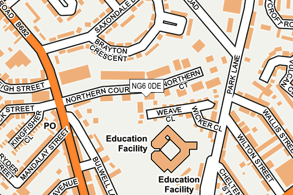
NG6 0DE is located in the Basford electoral ward, within the unitary authority of Nottingham and the English Parliamentary constituency of Nottingham North. The Sub Integrated Care Board (ICB) Location is NHS Nottingham and Nottinghamshire ICB - 52R and the police force is Nottinghamshire. This postcode has been in use since April 1985.


GetTheData
Source: OS OpenMap – Local (Ordnance Survey)
Source: OS VectorMap District (Ordnance Survey)
Licence: Open Government Licence (requires attribution)
| Easting | 454983 |
| Northing | 343935 |
| Latitude | 52.989936 |
| Longitude | -1.182363 |
GetTheData
Source: Open Postcode Geo
Licence: Open Government Licence
| Country | England |
| Postcode District | NG6 |
➜ See where NG6 is on a map ➜ Where is Nottingham? | |
GetTheData
Source: Land Registry Price Paid Data
Licence: Open Government Licence
Elevation or altitude of NG6 0DE as distance above sea level:
| Metres | Feet | |
|---|---|---|
| Elevation | 50m | 164ft |
Elevation is measured from the approximate centre of the postcode, to the nearest point on an OS contour line from OS Terrain 50, which has contour spacing of ten vertical metres.
➜ How high above sea level am I? Find the elevation of your current position using your device's GPS.
GetTheData
Source: Open Postcode Elevation
Licence: Open Government Licence
| Ward | Basford |
| Constituency | Nottingham North |
GetTheData
Source: ONS Postcode Database
Licence: Open Government Licence
| Wallis Street (Park Lane) | Highbury Vale | 158m |
| Catchems Corner (Highbury Road) | Highbury Vale | 184m |
| Gordon Street (Vernon Road) | Highbury Vale | 206m |
| Catchems Corner (Highbury Road) | Highbury Vale | 217m |
| Saxondale Drive (Brooklyn Road) | Highbury Vale | 287m |
| Highbury Vale Tram Stop (Highbury Vale) | Highbury Vale | 512m |
| David Lane Tram Stop (Vernon Road) | Basford | 563m |
| Basford Tram Stop (Vernon Road) | Basford | 955m |
| Cinderhill Tram Stop (Cinderhill Road) | Cinderhill | 1,237m |
| Bulwell Tram Stop (Station Road) | Bulwell | 1,383m |
| Bulwell Station | 1.4km |
| Nottingham Station | 5.3km |
GetTheData
Source: NaPTAN
Licence: Open Government Licence
GetTheData
Source: ONS Postcode Database
Licence: Open Government Licence


➜ Get more ratings from the Food Standards Agency
GetTheData
Source: Food Standards Agency
Licence: FSA terms & conditions
| Last Collection | |||
|---|---|---|---|
| Location | Mon-Fri | Sat | Distance |
| Vernon Road Post Office | 17:00 | 11:30 | 186m |
| Barlock Road | 17:30 | 12:00 | 399m |
| Southwark Street | 17:30 | 11:00 | 428m |
GetTheData
Source: Dracos
Licence: Creative Commons Attribution-ShareAlike
The below table lists the International Territorial Level (ITL) codes (formerly Nomenclature of Territorial Units for Statistics (NUTS) codes) and Local Administrative Units (LAU) codes for NG6 0DE:
| ITL 1 Code | Name |
|---|---|
| TLF | East Midlands (England) |
| ITL 2 Code | Name |
| TLF1 | Derbyshire and Nottinghamshire |
| ITL 3 Code | Name |
| TLF14 | Nottingham |
| LAU 1 Code | Name |
| E06000018 | Nottingham |
GetTheData
Source: ONS Postcode Directory
Licence: Open Government Licence
The below table lists the Census Output Area (OA), Lower Layer Super Output Area (LSOA), and Middle Layer Super Output Area (MSOA) for NG6 0DE:
| Code | Name | |
|---|---|---|
| OA | E00069756 | |
| LSOA | E01013836 | Nottingham 008E |
| MSOA | E02002875 | Nottingham 008 |
GetTheData
Source: ONS Postcode Directory
Licence: Open Government Licence
| NG6 0FH | Weave Close | 64m |
| NG6 0FQ | Wicker Close | 123m |
| NG6 9DZ | Brayton Crescent | 137m |
| NG6 9DY | Saxondale Drive | 162m |
| NG6 0BG | Vernon Road | 175m |
| NG6 0DT | Park Lane | 191m |
| NG6 9DX | Saxondale Drive | 196m |
| NG6 0BD | Vernon Road | 197m |
| NG6 0ER | Wilton Street | 233m |
| NG6 0LY | Rosegarth Walk | 234m |
GetTheData
Source: Open Postcode Geo; Land Registry Price Paid Data
Licence: Open Government Licence