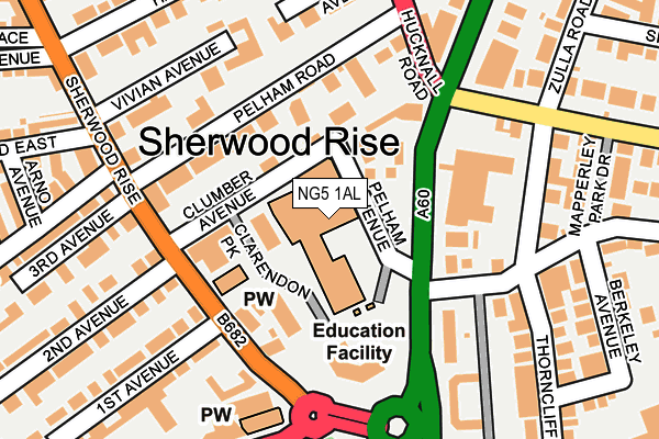
NG5 1AL is located in the Berridge electoral ward, within the unitary authority of Nottingham and the English Parliamentary constituency of Nottingham East. The Sub Integrated Care Board (ICB) Location is NHS Nottingham and Nottinghamshire ICB - 52R and the police force is Nottinghamshire. This postcode has been in use since January 1980.


GetTheData
Source: OS OpenMap – Local (Ordnance Survey)
Source: OS VectorMap District (Ordnance Survey)
Licence: Open Government Licence (requires attribution)
| Easting | 456850 |
| Northing | 341715 |
| Latitude | 52.969787 |
| Longitude | -1.154943 |
GetTheData
Source: Open Postcode Geo
Licence: Open Government Licence
| Country | England |
| Postcode District | NG5 |
➜ See where NG5 is on a map | |
GetTheData
Source: Land Registry Price Paid Data
Licence: Open Government Licence
Elevation or altitude of NG5 1AL as distance above sea level:
| Metres | Feet | |
|---|---|---|
| Elevation | 60m | 197ft |
Elevation is measured from the approximate centre of the postcode, to the nearest point on an OS contour line from OS Terrain 50, which has contour spacing of ten vertical metres.
➜ How high above sea level am I? Find the elevation of your current position using your device's GPS.
GetTheData
Source: Open Postcode Elevation
Licence: Open Government Licence
| Ward | Berridge |
| Constituency | Nottingham East |
GetTheData
Source: ONS Postcode Database
Licence: Open Government Licence
| Clarendon College (Mansfield Road) | Sherwood Rise | 97m |
| Clarendon College (Mansfield Road) | Sherwood Rise | 121m |
| Clarendon College (Mansfield Road) | Sherwood Rise | 134m |
| Gregory Boulevard (Sherwood Rise) | Sherwood Rise | 143m |
| Clarendon College (Mansfield Road) | Sherwood Rise | 150m |
| High School Tram Stop (Waverley Street) | Arboretum | 924m |
| Noel Street Tram Stop (Noel Street) | Hyson Green | 961m |
| The Forest Tram Stop (Noel Street) | The Forest | 976m |
| Beaconsfield Street Tram Stop (Noel Street) | Forest Fields | 1,066m |
| Hyson Green Market Tram Stop (Radford Road) | Hyson Green | 1,138m |
| Nottingham Station | 2.6km |
| Bulwell Station | 4.3km |
GetTheData
Source: NaPTAN
Licence: Open Government Licence
GetTheData
Source: ONS Postcode Database
Licence: Open Government Licence


➜ Get more ratings from the Food Standards Agency
GetTheData
Source: Food Standards Agency
Licence: FSA terms & conditions
| Last Collection | |||
|---|---|---|---|
| Location | Mon-Fri | Sat | Distance |
| Redcliffe Road | 17:30 | 12:00 | 184m |
| Sherwood Rise | 17:30 | 11:30 | 285m |
| Magdala Road | 17:30 | 12:00 | 321m |
GetTheData
Source: Dracos
Licence: Creative Commons Attribution-ShareAlike
The below table lists the International Territorial Level (ITL) codes (formerly Nomenclature of Territorial Units for Statistics (NUTS) codes) and Local Administrative Units (LAU) codes for NG5 1AL:
| ITL 1 Code | Name |
|---|---|
| TLF | East Midlands (England) |
| ITL 2 Code | Name |
| TLF1 | Derbyshire and Nottinghamshire |
| ITL 3 Code | Name |
| TLF14 | Nottingham |
| LAU 1 Code | Name |
| E06000018 | Nottingham |
GetTheData
Source: ONS Postcode Directory
Licence: Open Government Licence
The below table lists the Census Output Area (OA), Lower Layer Super Output Area (LSOA), and Middle Layer Super Output Area (MSOA) for NG5 1AL:
| Code | Name | |
|---|---|---|
| OA | E00069812 | |
| LSOA | E01013843 | Nottingham 017A |
| MSOA | E02002884 | Nottingham 017 |
GetTheData
Source: ONS Postcode Directory
Licence: Open Government Licence
| NG5 1AJ | Pelham Avenue | 73m |
| NG5 2BY | Mansfield Road | 88m |
| NG5 1AH | Clarendon Park | 104m |
| NG5 2BX | Mansfield Road | 113m |
| NG5 2BS | Mansfield Road | 114m |
| NG5 2BZ | Mansfield Road | 149m |
| NG5 1AP | Pelham Road | 165m |
| NG5 2BW | Mansfield Road | 195m |
| NG3 5BT | Redcliffe Road | 202m |
| NG3 5BY | Zulla Road | 206m |
GetTheData
Source: Open Postcode Geo; Land Registry Price Paid Data
Licence: Open Government Licence