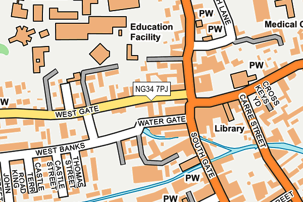
NG34 7PJ lies on Westgate in Sleaford. NG34 7PJ is located in the Sleaford Westholme electoral ward, within the local authority district of North Kesteven and the English Parliamentary constituency of Sleaford and North Hykeham. The Sub Integrated Care Board (ICB) Location is NHS Lincolnshire ICB - 71E and the police force is Lincolnshire. This postcode has been in use since January 1980.


GetTheData
Source: OS OpenMap – Local (Ordnance Survey)
Source: OS VectorMap District (Ordnance Survey)
Licence: Open Government Licence (requires attribution)
| Easting | 506702 |
| Northing | 345847 |
| Latitude | 52.999326 |
| Longitude | -0.411517 |
GetTheData
Source: Open Postcode Geo
Licence: Open Government Licence
| Street | Westgate |
| Town/City | Sleaford |
| Country | England |
| Postcode District | NG34 |
➜ See where NG34 is on a map ➜ Where is Sleaford? | |
GetTheData
Source: Land Registry Price Paid Data
Licence: Open Government Licence
Elevation or altitude of NG34 7PJ as distance above sea level:
| Metres | Feet | |
|---|---|---|
| Elevation | 20m | 66ft |
Elevation is measured from the approximate centre of the postcode, to the nearest point on an OS contour line from OS Terrain 50, which has contour spacing of ten vertical metres.
➜ How high above sea level am I? Find the elevation of your current position using your device's GPS.
GetTheData
Source: Open Postcode Elevation
Licence: Open Government Licence
| Ward | Sleaford Westholme |
| Constituency | Sleaford And North Hykeham |
GetTheData
Source: ONS Postcode Database
Licence: Open Government Licence
| Westgate House (Westgate) | Sleaford | 89m |
| Market Place (Eastgate) | Sleaford | 129m |
| Methodist Chapel (Northgate) | Sleaford | 146m |
| County Infants School (Church Lane) | Sleaford | 220m |
| St Denys Church (Eastgate) | Sleaford | 231m |
| Sleaford Station | 0.4km |
| Rauceby Station | 3.4km |
| Ruskington Station | 5.1km |
GetTheData
Source: NaPTAN
Licence: Open Government Licence
| Percentage of properties with Next Generation Access | 100.0% |
| Percentage of properties with Superfast Broadband | 100.0% |
| Percentage of properties with Ultrafast Broadband | 0.0% |
| Percentage of properties with Full Fibre Broadband | 0.0% |
Superfast Broadband is between 30Mbps and 300Mbps
Ultrafast Broadband is > 300Mbps
| Median download speed | 48.3Mbps |
| Average download speed | 53.0Mbps |
| Maximum download speed | 80.00Mbps |
| Median upload speed | 10.0Mbps |
| Average upload speed | 12.1Mbps |
| Maximum upload speed | 20.00Mbps |
| Percentage of properties unable to receive 2Mbps | 0.0% |
| Percentage of properties unable to receive 5Mbps | 0.0% |
| Percentage of properties unable to receive 10Mbps | 0.0% |
| Percentage of properties unable to receive 30Mbps | 0.0% |
GetTheData
Source: Ofcom
Licence: Ofcom Terms of Use (requires attribution)
Estimated total energy consumption in NG34 7PJ by fuel type, 2015.
| Consumption (kWh) | 69,032 |
|---|---|
| Meter count | 6 |
| Mean (kWh/meter) | 11,505 |
| Median (kWh/meter) | 11,415 |
GetTheData
Source: Postcode level gas estimates: 2015 (experimental)
Source: Postcode level electricity estimates: 2015 (experimental)
Licence: Open Government Licence
GetTheData
Source: ONS Postcode Database
Licence: Open Government Licence


➜ Get more ratings from the Food Standards Agency
GetTheData
Source: Food Standards Agency
Licence: FSA terms & conditions
| Last Collection | |||
|---|---|---|---|
| Location | Mon-Fri | Sat | Distance |
| Southgate Centre | 17:45 | 11:00 | 114m |
| Market Place | 18:30 | 10:30 | 125m |
| Market Place | 18:30 | 11:15 | 127m |
GetTheData
Source: Dracos
Licence: Creative Commons Attribution-ShareAlike
The below table lists the International Territorial Level (ITL) codes (formerly Nomenclature of Territorial Units for Statistics (NUTS) codes) and Local Administrative Units (LAU) codes for NG34 7PJ:
| ITL 1 Code | Name |
|---|---|
| TLF | East Midlands (England) |
| ITL 2 Code | Name |
| TLF3 | Lincolnshire |
| ITL 3 Code | Name |
| TLF30 | Lincolnshire CC |
| LAU 1 Code | Name |
| E07000139 | North Kesteven |
GetTheData
Source: ONS Postcode Directory
Licence: Open Government Licence
The below table lists the Census Output Area (OA), Lower Layer Super Output Area (LSOA), and Middle Layer Super Output Area (MSOA) for NG34 7PJ:
| Code | Name | |
|---|---|---|
| OA | E00133189 | |
| LSOA | E01026227 | North Kesteven 010A |
| MSOA | E02005462 | North Kesteven 010 |
GetTheData
Source: ONS Postcode Directory
Licence: Open Government Licence
| NG34 7PN | Westgate | 29m |
| NG34 7PG | Watergate | 32m |
| NG34 7YQ | Toft Lane | 48m |
| NG34 7BH | Northgate | 76m |
| NG34 7BN | Northgate | 77m |
| NG34 7PQ | West Banks | 82m |
| NG34 7RZ | Southgate | 82m |
| NG34 7PW | Liverpool Cottages | 97m |
| NG34 7PX | West Banks | 99m |
| NG34 7SF | Market Street | 116m |
GetTheData
Source: Open Postcode Geo; Land Registry Price Paid Data
Licence: Open Government Licence