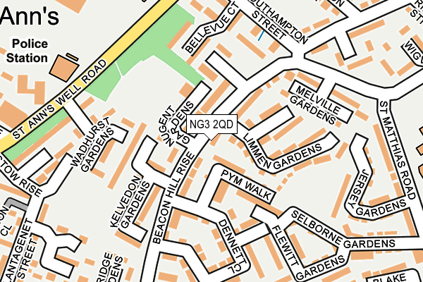
NG3 2QD lies on Limmen Gardens in Nottingham. NG3 2QD is located in the St. Ann's electoral ward, within the unitary authority of Nottingham and the English Parliamentary constituency of Nottingham East. The Sub Integrated Care Board (ICB) Location is NHS Nottingham and Nottinghamshire ICB - 52R and the police force is Nottinghamshire. This postcode has been in use since January 1980.


GetTheData
Source: OS OpenMap – Local (Ordnance Survey)
Source: OS VectorMap District (Ordnance Survey)
Licence: Open Government Licence (requires attribution)
| Easting | 458178 |
| Northing | 340670 |
| Latitude | 52.960253 |
| Longitude | -1.135359 |
GetTheData
Source: Open Postcode Geo
Licence: Open Government Licence
| Street | Limmen Gardens |
| Town/City | Nottingham |
| Country | England |
| Postcode District | NG3 |
➜ See where NG3 is on a map ➜ Where is Nottingham? | |
GetTheData
Source: Land Registry Price Paid Data
Licence: Open Government Licence
Elevation or altitude of NG3 2QD as distance above sea level:
| Metres | Feet | |
|---|---|---|
| Elevation | 50m | 164ft |
Elevation is measured from the approximate centre of the postcode, to the nearest point on an OS contour line from OS Terrain 50, which has contour spacing of ten vertical metres.
➜ How high above sea level am I? Find the elevation of your current position using your device's GPS.
GetTheData
Source: Open Postcode Elevation
Licence: Open Government Licence
| Ward | St. Ann's |
| Constituency | Nottingham East |
GetTheData
Source: ONS Postcode Database
Licence: Open Government Licence
| Nugent Gardens (Beacon Hill Rise) | St Anns | 92m |
| Nugent Gardens (Beacon Hill Rise) | St Anns | 109m |
| Kelvedon Gardens (Beacon Hill Rise) | St Anns | 138m |
| Robin Hood Chase (St Anns Well Road) | St Anns | 180m |
| Robin Hood Chase (St Anns Well Road) | St Anns | 196m |
| Lace Market Tram Stop (Fletcher Gate) | Nottingham | 1,043m |
| Royal Centre Tram Stop (Wollaton Street) | Nottingham | 1,257m |
| Old Market Square Tram Stop (South Parade) | Nottingham | 1,308m |
| Ntu Tram Stop (Goldsmith Street) | Nottingham Trent University In City Centre | 1,381m |
| Nottingham Station Tram Stop (N/A) | Nottingham | 1,644m |
| Nottingham Station | 1.6km |
| Netherfield Station | 3.7km |
| Carlton Station | 3.8km |
GetTheData
Source: NaPTAN
Licence: Open Government Licence
| Percentage of properties with Next Generation Access | 100.0% |
| Percentage of properties with Superfast Broadband | 100.0% |
| Percentage of properties with Ultrafast Broadband | 100.0% |
| Percentage of properties with Full Fibre Broadband | 33.3% |
Superfast Broadband is between 30Mbps and 300Mbps
Ultrafast Broadband is > 300Mbps
| Median download speed | 22.4Mbps |
| Average download speed | 67.2Mbps |
| Maximum download speed | 200.00Mbps |
| Median upload speed | 1.2Mbps |
| Average upload speed | 1.2Mbps |
| Maximum upload speed | 1.29Mbps |
| Percentage of properties unable to receive 2Mbps | 0.0% |
| Percentage of properties unable to receive 5Mbps | 0.0% |
| Percentage of properties unable to receive 10Mbps | 0.0% |
| Percentage of properties unable to receive 30Mbps | 0.0% |
GetTheData
Source: Ofcom
Licence: Ofcom Terms of Use (requires attribution)
GetTheData
Source: ONS Postcode Database
Licence: Open Government Licence


➜ Get more ratings from the Food Standards Agency
GetTheData
Source: Food Standards Agency
Licence: FSA terms & conditions
| Last Collection | |||
|---|---|---|---|
| Location | Mon-Fri | Sat | Distance |
| Beaconhill Rise | 17:30 | 11:00 | 77m |
| Instow Rise | 18:00 | 12:00 | 322m |
| St Anns Post Office | 17:15 | 11:30 | 353m |
GetTheData
Source: Dracos
Licence: Creative Commons Attribution-ShareAlike
The below table lists the International Territorial Level (ITL) codes (formerly Nomenclature of Territorial Units for Statistics (NUTS) codes) and Local Administrative Units (LAU) codes for NG3 2QD:
| ITL 1 Code | Name |
|---|---|
| TLF | East Midlands (England) |
| ITL 2 Code | Name |
| TLF1 | Derbyshire and Nottinghamshire |
| ITL 3 Code | Name |
| TLF14 | Nottingham |
| LAU 1 Code | Name |
| E06000018 | Nottingham |
GetTheData
Source: ONS Postcode Directory
Licence: Open Government Licence
The below table lists the Census Output Area (OA), Lower Layer Super Output Area (LSOA), and Middle Layer Super Output Area (MSOA) for NG3 2QD:
| Code | Name | |
|---|---|---|
| OA | E00070444 | |
| LSOA | E01013960 | Nottingham 021C |
| MSOA | E02002888 | Nottingham 021 |
GetTheData
Source: ONS Postcode Directory
Licence: Open Government Licence
| NG3 2QA | Limmen Gardens | 79m |
| NG3 3NB | Nugent Gardens | 86m |
| NG3 2GQ | Pym Walk | 86m |
| NG3 2GX | Beacon Hill Rise | 87m |
| NG3 1LQ | Kelvedon Gardens | 118m |
| NG3 2QE | Limmen Gardens | 125m |
| NG3 3NA | Bellevue Court | 140m |
| NG3 2QF | Melville Gardens | 151m |
| NG3 1LP | Wadhurst Gardens | 163m |
| NG3 2GL | Dennett Close | 167m |
GetTheData
Source: Open Postcode Geo; Land Registry Price Paid Data
Licence: Open Government Licence