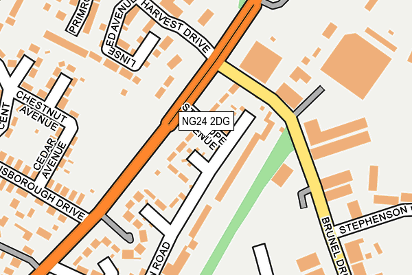
NG24 2DG lies on Stanhope Avenue in Newark. NG24 2DG is located in the Bridge electoral ward, within the local authority district of Newark and Sherwood and the English Parliamentary constituency of Newark. The Sub Integrated Care Board (ICB) Location is NHS Nottingham and Nottinghamshire ICB - 52R and the police force is Nottinghamshire. This postcode has been in use since January 1980.


GetTheData
Source: OS OpenMap – Local (Ordnance Survey)
Source: OS VectorMap District (Ordnance Survey)
Licence: Open Government Licence (requires attribution)
| Easting | 481126 |
| Northing | 355496 |
| Latitude | 53.090521 |
| Longitude | -0.790084 |
GetTheData
Source: Open Postcode Geo
Licence: Open Government Licence
| Street | Stanhope Avenue |
| Town/City | Newark |
| Country | England |
| Postcode District | NG24 |
➜ See where NG24 is on a map ➜ Where is Newark-on-Trent? | |
GetTheData
Source: Land Registry Price Paid Data
Licence: Open Government Licence
Elevation or altitude of NG24 2DG as distance above sea level:
| Metres | Feet | |
|---|---|---|
| Elevation | 10m | 33ft |
Elevation is measured from the approximate centre of the postcode, to the nearest point on an OS contour line from OS Terrain 50, which has contour spacing of ten vertical metres.
➜ How high above sea level am I? Find the elevation of your current position using your device's GPS.
GetTheData
Source: Open Postcode Elevation
Licence: Open Government Licence
| Ward | Bridge |
| Constituency | Newark |
GetTheData
Source: ONS Postcode Database
Licence: Open Government Licence
| Gainsborough Drive (Lincoln Road) | Newark | 198m |
| Gainsborough Drive (Lincoln Road) | Newark | 203m |
| Park Crescent (Winthorpe Road) | Winthorpe Road Estate | 397m |
| Winthorpe Road (Stephen Road) | Winthorpe Road Estate | 448m |
| Meering Avenue (Wolsey Road) | Winthorpe Road Estate | 471m |
| Newark North Gate Station | 1.2km |
| Newark Castle Station | 1.9km |
GetTheData
Source: NaPTAN
Licence: Open Government Licence
| Percentage of properties with Next Generation Access | 100.0% |
| Percentage of properties with Superfast Broadband | 100.0% |
| Percentage of properties with Ultrafast Broadband | 100.0% |
| Percentage of properties with Full Fibre Broadband | 0.0% |
Superfast Broadband is between 30Mbps and 300Mbps
Ultrafast Broadband is > 300Mbps
| Median download speed | 100.0Mbps |
| Average download speed | 125.0Mbps |
| Maximum download speed | 200.00Mbps |
Ofcom does not currently provide upload speed data for NG24 2DG. This is because there are less than four broadband connections in this postcode.
| Percentage of properties unable to receive 2Mbps | 0.0% |
| Percentage of properties unable to receive 5Mbps | 0.0% |
| Percentage of properties unable to receive 10Mbps | 0.0% |
| Percentage of properties unable to receive 30Mbps | 0.0% |
GetTheData
Source: Ofcom
Licence: Ofcom Terms of Use (requires attribution)
Estimated total energy consumption in NG24 2DG by fuel type, 2015.
| Consumption (kWh) | 118,225 |
|---|---|
| Meter count | 7 |
| Mean (kWh/meter) | 16,889 |
| Median (kWh/meter) | 14,718 |
| Consumption (kWh) | 17,345 |
|---|---|
| Meter count | 6 |
| Mean (kWh/meter) | 2,891 |
| Median (kWh/meter) | 3,109 |
GetTheData
Source: Postcode level gas estimates: 2015 (experimental)
Source: Postcode level electricity estimates: 2015 (experimental)
Licence: Open Government Licence
GetTheData
Source: ONS Postcode Database
Licence: Open Government Licence


➜ Get more ratings from the Food Standards Agency
GetTheData
Source: Food Standards Agency
Licence: FSA terms & conditions
| Last Collection | |||
|---|---|---|---|
| Location | Mon-Fri | Sat | Distance |
| Lincoln Road Post Office | 17:30 | 11:30 | 297m |
| Yorke Drive | 17:30 | 11:45 | 648m |
| Northgate Station | 18:30 | 11:30 | 1,167m |
GetTheData
Source: Dracos
Licence: Creative Commons Attribution-ShareAlike
The below table lists the International Territorial Level (ITL) codes (formerly Nomenclature of Territorial Units for Statistics (NUTS) codes) and Local Administrative Units (LAU) codes for NG24 2DG:
| ITL 1 Code | Name |
|---|---|
| TLF | East Midlands (England) |
| ITL 2 Code | Name |
| TLF1 | Derbyshire and Nottinghamshire |
| ITL 3 Code | Name |
| TLF15 | North Nottinghamshire |
| LAU 1 Code | Name |
| E07000175 | Newark and Sherwood |
GetTheData
Source: ONS Postcode Directory
Licence: Open Government Licence
The below table lists the Census Output Area (OA), Lower Layer Super Output Area (LSOA), and Middle Layer Super Output Area (MSOA) for NG24 2DG:
| Code | Name | |
|---|---|---|
| OA | E00144219 | |
| LSOA | E01028307 | Newark and Sherwood 007E |
| MSOA | E02005899 | Newark and Sherwood 007 |
GetTheData
Source: ONS Postcode Directory
Licence: Open Government Licence
| NG24 2DF | Lincoln Road | 21m |
| NG24 2DH | Pembroke Crescent | 92m |
| NG24 2FJ | Linseed Avenue | 165m |
| NG24 2DJ | Clifton Crescent | 168m |
| NG24 2DN | Middleton Road | 169m |
| NG24 2FN | Farmers Walk | 183m |
| NG24 2DA | Cedar Avenue | 203m |
| NG24 2BZ | Chestnut Avenue | 240m |
| NG24 2DL | Middleton Road | 249m |
| NG24 2AS | Hollies Avenue | 255m |
GetTheData
Source: Open Postcode Geo; Land Registry Price Paid Data
Licence: Open Government Licence