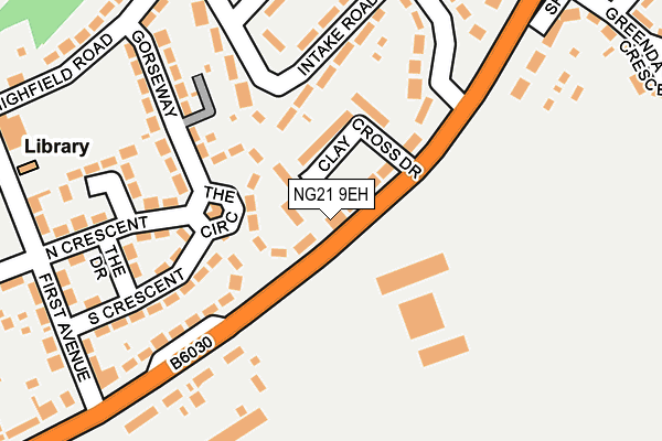
NG21 9EH lies on Mansfield Road in Clipstone Village, Mansfield. NG21 9EH is located in the Edwinstowe & Clipstone electoral ward, within the local authority district of Newark and Sherwood and the English Parliamentary constituency of Sherwood. The Sub Integrated Care Board (ICB) Location is NHS Nottingham and Nottinghamshire ICB - 52R and the police force is Nottinghamshire. This postcode has been in use since January 1980.


GetTheData
Source: OS OpenMap – Local (Ordnance Survey)
Source: OS VectorMap District (Ordnance Survey)
Licence: Open Government Licence (requires attribution)
| Easting | 459450 |
| Northing | 363349 |
| Latitude | 53.163971 |
| Longitude | -1.112243 |
GetTheData
Source: Open Postcode Geo
Licence: Open Government Licence
| Street | Mansfield Road |
| Locality | Clipstone Village |
| Town/City | Mansfield |
| Country | England |
| Postcode District | NG21 |
➜ See where NG21 is on a map ➜ Where is Clipstone? | |
GetTheData
Source: Land Registry Price Paid Data
Licence: Open Government Licence
Elevation or altitude of NG21 9EH as distance above sea level:
| Metres | Feet | |
|---|---|---|
| Elevation | 90m | 295ft |
Elevation is measured from the approximate centre of the postcode, to the nearest point on an OS contour line from OS Terrain 50, which has contour spacing of ten vertical metres.
➜ How high above sea level am I? Find the elevation of your current position using your device's GPS.
GetTheData
Source: Open Postcode Elevation
Licence: Open Government Licence
| Ward | Edwinstowe & Clipstone |
| Constituency | Sherwood |
GetTheData
Source: ONS Postcode Database
Licence: Open Government Licence
| Colliery (Mansfield Road) | Clipstone | 47m |
| Colliery (Mansfield Road) | Clipstone | 70m |
| First Avenue (Mansfield Road) | Clipstone | 249m |
| King Johns Road | Clipstone | 258m |
| Gorseway (Highfield Road) | Clipstone | 259m |
GetTheData
Source: NaPTAN
Licence: Open Government Licence
Estimated total energy consumption in NG21 9EH by fuel type, 2015.
| Consumption (kWh) | 193,540 |
|---|---|
| Meter count | 6 |
| Mean (kWh/meter) | 32,257 |
| Median (kWh/meter) | 32,020 |
| Consumption (kWh) | 62,149 |
|---|---|
| Meter count | 27 |
| Mean (kWh/meter) | 2,302 |
| Median (kWh/meter) | 2,107 |
GetTheData
Source: Postcode level gas estimates: 2015 (experimental)
Source: Postcode level electricity estimates: 2015 (experimental)
Licence: Open Government Licence
GetTheData
Source: ONS Postcode Database
Licence: Open Government Licence


➜ Get more ratings from the Food Standards Agency
GetTheData
Source: Food Standards Agency
Licence: FSA terms & conditions
| Last Collection | |||
|---|---|---|---|
| Location | Mon-Fri | Sat | Distance |
| Main Road | 16:15 | 11:00 | 128m |
| Clipstone Colly | 16:15 | 11:00 | 202m |
| Hilcote Drive | 16:15 | 11:00 | 712m |
GetTheData
Source: Dracos
Licence: Creative Commons Attribution-ShareAlike
The below table lists the International Territorial Level (ITL) codes (formerly Nomenclature of Territorial Units for Statistics (NUTS) codes) and Local Administrative Units (LAU) codes for NG21 9EH:
| ITL 1 Code | Name |
|---|---|
| TLF | East Midlands (England) |
| ITL 2 Code | Name |
| TLF1 | Derbyshire and Nottinghamshire |
| ITL 3 Code | Name |
| TLF15 | North Nottinghamshire |
| LAU 1 Code | Name |
| E07000175 | Newark and Sherwood |
GetTheData
Source: ONS Postcode Directory
Licence: Open Government Licence
The below table lists the Census Output Area (OA), Lower Layer Super Output Area (LSOA), and Middle Layer Super Output Area (MSOA) for NG21 9EH:
| Code | Name | |
|---|---|---|
| OA | E00144266 | |
| LSOA | E01028313 | Newark and Sherwood 002A |
| MSOA | E02005894 | Newark and Sherwood 002 |
GetTheData
Source: ONS Postcode Directory
Licence: Open Government Licence
| NG21 9FG | Dunsil Row | 34m |
| NG21 9FJ | Clay Cross Drive | 64m |
| NG21 9EF | The Circle | 79m |
| NG21 9EU | Intake Road | 167m |
| NG21 9EG | Gorseway | 172m |
| NG21 9ED | South Crescent | 174m |
| NG21 9EQ | Mansfield Road | 184m |
| NG21 9AP | Mansfield Road | 196m |
| NG21 9BA | Mansfield Road | 206m |
| NG21 9EN | King Johns Road | 210m |
GetTheData
Source: Open Postcode Geo; Land Registry Price Paid Data
Licence: Open Government Licence