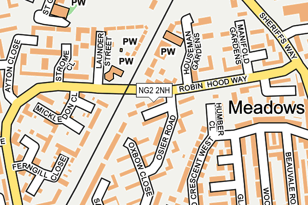
NG2 2NH lies on Hoopers Walk in Nottingham. NG2 2NH is located in the Meadows electoral ward, within the unitary authority of Nottingham and the English Parliamentary constituency of Nottingham South. The Sub Integrated Care Board (ICB) Location is NHS Nottingham and Nottinghamshire ICB - 52R and the police force is Nottinghamshire. This postcode has been in use since January 1980.


GetTheData
Source: OS OpenMap – Local (Ordnance Survey)
Source: OS VectorMap District (Ordnance Survey)
Licence: Open Government Licence (requires attribution)
| Easting | 457188 |
| Northing | 338574 |
| Latitude | 52.941520 |
| Longitude | -1.150464 |
GetTheData
Source: Open Postcode Geo
Licence: Open Government Licence
| Street | Hoopers Walk |
| Town/City | Nottingham |
| Country | England |
| Postcode District | NG2 |
➜ See where NG2 is on a map ➜ Where is Nottingham? | |
GetTheData
Source: Land Registry Price Paid Data
Licence: Open Government Licence
Elevation or altitude of NG2 2NH as distance above sea level:
| Metres | Feet | |
|---|---|---|
| Elevation | 30m | 98ft |
Elevation is measured from the approximate centre of the postcode, to the nearest point on an OS contour line from OS Terrain 50, which has contour spacing of ten vertical metres.
➜ How high above sea level am I? Find the elevation of your current position using your device's GPS.
GetTheData
Source: Open Postcode Elevation
Licence: Open Government Licence
| Ward | Meadows |
| Constituency | Nottingham South |
GetTheData
Source: ONS Postcode Database
Licence: Open Government Licence
| Houseman Gardens (Robin Hood Way) | Meadows | 71m |
| Queens Walk (Robin Hood Way) | Meadows | 88m |
| Houseman Gardens (Robin Hood Way) | Meadows | 100m |
| Queens Walk (Robin Hood Way) | Meadows | 132m |
| Manifold Gardens (Robin Hood Way) | Meadows | 221m |
| Queens Walk Tram Stop (Queens Walk) | Meadows | 138m |
| Meadows Embankment Tram Stop (Queens Walk) | Meadows | 349m |
| Meadows Way West Tram Stop (Meadows Way) | Meadows | 467m |
| Nottingham Station Tram Stop (N/A) | Nottingham | 675m |
| Wilford Village Tram Stop (Main Road) | Wilford | 734m |
| Nottingham Station | 0.7km |
| Beeston Station | 4.5km |
| Netherfield Station | 5.2km |
GetTheData
Source: NaPTAN
Licence: Open Government Licence
| Percentage of properties with Next Generation Access | 100.0% |
| Percentage of properties with Superfast Broadband | 100.0% |
| Percentage of properties with Ultrafast Broadband | 100.0% |
| Percentage of properties with Full Fibre Broadband | 0.0% |
Superfast Broadband is between 30Mbps and 300Mbps
Ultrafast Broadband is > 300Mbps
| Percentage of properties unable to receive 2Mbps | 0.0% |
| Percentage of properties unable to receive 5Mbps | 0.0% |
| Percentage of properties unable to receive 10Mbps | 0.0% |
| Percentage of properties unable to receive 30Mbps | 0.0% |
GetTheData
Source: Ofcom
Licence: Ofcom Terms of Use (requires attribution)
GetTheData
Source: ONS Postcode Database
Licence: Open Government Licence


➜ Get more ratings from the Food Standards Agency
GetTheData
Source: Food Standards Agency
Licence: FSA terms & conditions
| Last Collection | |||
|---|---|---|---|
| Location | Mon-Fri | Sat | Distance |
| Thrumpton Drive | 17:30 | 11:30 | 309m |
| Woolmer Road | 17:30 | 11:30 | 328m |
| The Meadows Post Office | 17:00 | 12:00 | 378m |
GetTheData
Source: Dracos
Licence: Creative Commons Attribution-ShareAlike
The below table lists the International Territorial Level (ITL) codes (formerly Nomenclature of Territorial Units for Statistics (NUTS) codes) and Local Administrative Units (LAU) codes for NG2 2NH:
| ITL 1 Code | Name |
|---|---|
| TLF | East Midlands (England) |
| ITL 2 Code | Name |
| TLF1 | Derbyshire and Nottinghamshire |
| ITL 3 Code | Name |
| TLF14 | Nottingham |
| LAU 1 Code | Name |
| E06000018 | Nottingham |
GetTheData
Source: ONS Postcode Directory
Licence: Open Government Licence
The below table lists the Census Output Area (OA), Lower Layer Super Output Area (LSOA), and Middle Layer Super Output Area (MSOA) for NG2 2NH:
| Code | Name | |
|---|---|---|
| OA | E00069971 | |
| LSOA | E01013871 | Nottingham 040B |
| MSOA | E02006905 | Nottingham 040 |
GetTheData
Source: ONS Postcode Directory
Licence: Open Government Licence
| NG2 2NJ | Aldermens Close | 33m |
| NG2 2NL | Osier Road | 77m |
| NG2 2NG | Hethbeth Court | 79m |
| NG2 1LG | Wetherlam Close | 111m |
| NG2 2FX | Humber Close | 133m |
| NG2 1LF | Helvellyn Close | 145m |
| NG2 2HX | Houseman Gardens | 145m |
| NG2 2NN | Oxbow Close | 158m |
| NG2 1HJ | Branksome Walk | 163m |
| NG2 2NE | Doyne Court | 174m |
GetTheData
Source: Open Postcode Geo; Land Registry Price Paid Data
Licence: Open Government Licence