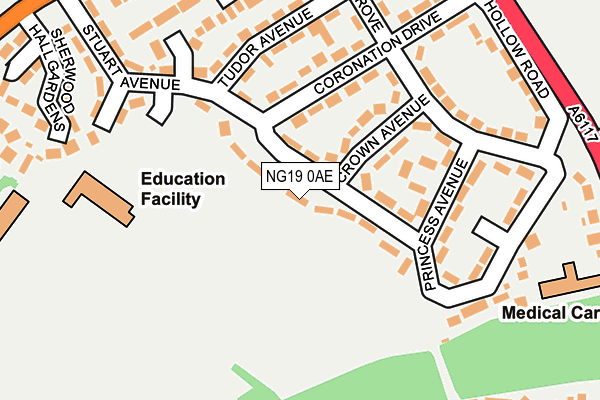
NG19 0AE lies on Stuart Avenue in Forest Town, Mansfield. NG19 0AE is located in the Kingsway Forest Town electoral ward, within the local authority district of Mansfield and the English Parliamentary constituency of Mansfield. The Sub Integrated Care Board (ICB) Location is NHS Nottingham and Nottinghamshire ICB - 52R and the police force is Nottinghamshire. This postcode has been in use since January 1980.


GetTheData
Source: OS OpenMap – Local (Ordnance Survey)
Source: OS VectorMap District (Ordnance Survey)
Licence: Open Government Licence (requires attribution)
| Easting | 455963 |
| Northing | 361574 |
| Latitude | 53.148376 |
| Longitude | -1.164705 |
GetTheData
Source: Open Postcode Geo
Licence: Open Government Licence
| Street | Stuart Avenue |
| Locality | Forest Town |
| Town/City | Mansfield |
| Country | England |
| Postcode District | NG19 |
➜ See where NG19 is on a map ➜ Where is Forest Town? | |
GetTheData
Source: Land Registry Price Paid Data
Licence: Open Government Licence
Elevation or altitude of NG19 0AE as distance above sea level:
| Metres | Feet | |
|---|---|---|
| Elevation | 110m | 361ft |
Elevation is measured from the approximate centre of the postcode, to the nearest point on an OS contour line from OS Terrain 50, which has contour spacing of ten vertical metres.
➜ How high above sea level am I? Find the elevation of your current position using your device's GPS.
GetTheData
Source: Open Postcode Elevation
Licence: Open Government Licence
| Ward | Kingsway Forest Town |
| Constituency | Mansfield |
GetTheData
Source: ONS Postcode Database
Licence: Open Government Licence
| Community Centre (Stuart Avenue) | Sherwood Hall | 75m |
| Community Centre (Stuart Avenue) | Sherwood Hall | 81m |
| Princess Avenue | Sherwood Hall | 143m |
| Princess Avenue | Sherwood Hall | 154m |
| Tudor Avenue (Stuart Avenue) | Sherwood Hall | 172m |
| Mansfield Station | 2.4km |
| Mansfield Woodhouse Station | 3km |
GetTheData
Source: NaPTAN
Licence: Open Government Licence
| Percentage of properties with Next Generation Access | 100.0% |
| Percentage of properties with Superfast Broadband | 100.0% |
| Percentage of properties with Ultrafast Broadband | 100.0% |
| Percentage of properties with Full Fibre Broadband | 0.0% |
Superfast Broadband is between 30Mbps and 300Mbps
Ultrafast Broadband is > 300Mbps
| Median download speed | 39.1Mbps |
| Average download speed | 87.5Mbps |
| Maximum download speed | 350.00Mbps |
| Median upload speed | 1.2Mbps |
| Average upload speed | 4.7Mbps |
| Maximum upload speed | 9.93Mbps |
| Percentage of properties unable to receive 2Mbps | 0.0% |
| Percentage of properties unable to receive 5Mbps | 0.0% |
| Percentage of properties unable to receive 10Mbps | 0.0% |
| Percentage of properties unable to receive 30Mbps | 0.0% |
GetTheData
Source: Ofcom
Licence: Ofcom Terms of Use (requires attribution)
Estimated total energy consumption in NG19 0AE by fuel type, 2015.
| Consumption (kWh) | 402,535 |
|---|---|
| Meter count | 27 |
| Mean (kWh/meter) | 14,909 |
| Median (kWh/meter) | 13,857 |
| Consumption (kWh) | 72,317 |
|---|---|
| Meter count | 26 |
| Mean (kWh/meter) | 2,781 |
| Median (kWh/meter) | 2,433 |
GetTheData
Source: Postcode level gas estimates: 2015 (experimental)
Source: Postcode level electricity estimates: 2015 (experimental)
Licence: Open Government Licence
GetTheData
Source: ONS Postcode Database
Licence: Open Government Licence


➜ Get more ratings from the Food Standards Agency
GetTheData
Source: Food Standards Agency
Licence: FSA terms & conditions
| Last Collection | |||
|---|---|---|---|
| Location | Mon-Fri | Sat | Distance |
| Bramble Lane | 17:00 | 11:00 | 1,411m |
| Ratcliffe Gate | 17:30 | 11:00 | 1,537m |
| Berry Hill Road | 17:00 | 11:00 | 1,661m |
GetTheData
Source: Dracos
Licence: Creative Commons Attribution-ShareAlike
The below table lists the International Territorial Level (ITL) codes (formerly Nomenclature of Territorial Units for Statistics (NUTS) codes) and Local Administrative Units (LAU) codes for NG19 0AE:
| ITL 1 Code | Name |
|---|---|
| TLF | East Midlands (England) |
| ITL 2 Code | Name |
| TLF1 | Derbyshire and Nottinghamshire |
| ITL 3 Code | Name |
| TLF15 | North Nottinghamshire |
| LAU 1 Code | Name |
| E07000174 | Mansfield |
GetTheData
Source: ONS Postcode Directory
Licence: Open Government Licence
The below table lists the Census Output Area (OA), Lower Layer Super Output Area (LSOA), and Middle Layer Super Output Area (MSOA) for NG19 0AE:
| Code | Name | |
|---|---|---|
| OA | E00143884 | |
| LSOA | E01028243 | Mansfield 007F |
| MSOA | E02005886 | Mansfield 007 |
GetTheData
Source: ONS Postcode Directory
Licence: Open Government Licence
| NG19 0AQ | Crown Avenue | 101m |
| NG19 0AL | Tudor Avenue | 155m |
| NG19 0AJ | Coronation Drive | 163m |
| NG19 0AR | Olive Grove | 190m |
| NG19 0AS | Pump Hollow Lane | 194m |
| NG19 0AN | Vesper Court | 204m |
| NG19 0AB | Stuart Avenue | 212m |
| NG19 0AP | Olive Grove | 227m |
| NG19 0AF | Hanover Close | 229m |
| NG18 2EJ | Sherwood Grange | 235m |
GetTheData
Source: Open Postcode Geo; Land Registry Price Paid Data
Licence: Open Government Licence