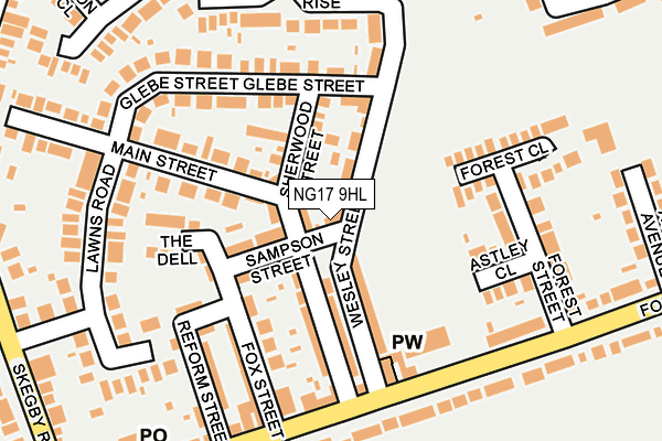
NG17 9HL lies on Sampson Street in Kirkby In Ashfield, Nottingham. NG17 9HL is located in the Annesley & Kirkby Woodhouse electoral ward, within the local authority district of Ashfield and the English Parliamentary constituency of Ashfield. The Sub Integrated Care Board (ICB) Location is NHS Nottingham and Nottinghamshire ICB - 52R and the police force is Nottinghamshire. This postcode has been in use since January 1980.


GetTheData
Source: OS OpenMap – Local (Ordnance Survey)
Source: OS VectorMap District (Ordnance Survey)
Licence: Open Government Licence (requires attribution)
| Easting | 450083 |
| Northing | 353720 |
| Latitude | 53.078366 |
| Longitude | -1.253836 |
GetTheData
Source: Open Postcode Geo
Licence: Open Government Licence
| Street | Sampson Street |
| Locality | Kirkby In Ashfield |
| Town/City | Nottingham |
| Country | England |
| Postcode District | NG17 |
➜ See where NG17 is on a map ➜ Where is Annesley Woodhouse? | |
GetTheData
Source: Land Registry Price Paid Data
Licence: Open Government Licence
Elevation or altitude of NG17 9HL as distance above sea level:
| Metres | Feet | |
|---|---|---|
| Elevation | 180m | 591ft |
Elevation is measured from the approximate centre of the postcode, to the nearest point on an OS contour line from OS Terrain 50, which has contour spacing of ten vertical metres.
➜ How high above sea level am I? Find the elevation of your current position using your device's GPS.
GetTheData
Source: Open Postcode Elevation
Licence: Open Government Licence
| Ward | Annesley & Kirkby Woodhouse |
| Constituency | Ashfield |
GetTheData
Source: ONS Postcode Database
Licence: Open Government Licence
| Fox Street (Forest Road) | Annesley Woodhouse | 186m |
| Fox Street (Forest Road) | Annesley Woodhouse | 205m |
| Acacia Avenue (Forest Road) | Annesley | 289m |
| Lawns Road (Skegby Road) | Annesley Woodhouse | 312m |
| Lawns Road (Skegby Road) | Annesley Woodhouse | 323m |
| Newstead Station | 2.3km |
| Kirkby in Ashfield Station | 2.4km |
| Sutton Parkway Station | 4km |
GetTheData
Source: NaPTAN
Licence: Open Government Licence
| Percentage of properties with Next Generation Access | 100.0% |
| Percentage of properties with Superfast Broadband | 100.0% |
| Percentage of properties with Ultrafast Broadband | 100.0% |
| Percentage of properties with Full Fibre Broadband | 0.0% |
Superfast Broadband is between 30Mbps and 300Mbps
Ultrafast Broadband is > 300Mbps
| Percentage of properties unable to receive 2Mbps | 0.0% |
| Percentage of properties unable to receive 5Mbps | 0.0% |
| Percentage of properties unable to receive 10Mbps | 0.0% |
| Percentage of properties unable to receive 30Mbps | 0.0% |
GetTheData
Source: Ofcom
Licence: Ofcom Terms of Use (requires attribution)
GetTheData
Source: ONS Postcode Database
Licence: Open Government Licence


➜ Get more ratings from the Food Standards Agency
GetTheData
Source: Food Standards Agency
Licence: FSA terms & conditions
| Last Collection | |||
|---|---|---|---|
| Location | Mon-Fri | Sat | Distance |
| Derby Road | 16:45 | 11:30 | 771m |
| St Johns Avenue | 17:30 | 11:45 | 2,119m |
| Diamond Avenue | 18:30 | 11:45 | 2,372m |
GetTheData
Source: Dracos
Licence: Creative Commons Attribution-ShareAlike
The below table lists the International Territorial Level (ITL) codes (formerly Nomenclature of Territorial Units for Statistics (NUTS) codes) and Local Administrative Units (LAU) codes for NG17 9HL:
| ITL 1 Code | Name |
|---|---|
| TLF | East Midlands (England) |
| ITL 2 Code | Name |
| TLF1 | Derbyshire and Nottinghamshire |
| ITL 3 Code | Name |
| TLF15 | North Nottinghamshire |
| LAU 1 Code | Name |
| E07000170 | Ashfield |
GetTheData
Source: ONS Postcode Directory
Licence: Open Government Licence
The below table lists the Census Output Area (OA), Lower Layer Super Output Area (LSOA), and Middle Layer Super Output Area (MSOA) for NG17 9HL:
| Code | Name | |
|---|---|---|
| OA | E00142646 | |
| LSOA | E01027998 | Ashfield 010D |
| MSOA | E02005828 | Ashfield 010 |
GetTheData
Source: ONS Postcode Directory
Licence: Open Government Licence
| NG17 9HQ | Sherwood Street | 53m |
| NG17 9HT | Sampson Street | 77m |
| NG17 9HN | Wesley Street | 82m |
| NG17 9HJ | Wesley Street | 82m |
| NG17 9HS | Main Street | 98m |
| NG17 9HU | Sherwood Street | 100m |
| NG17 9HR | Main Street | 122m |
| NG17 9HX | Fox Street | 139m |
| NG17 9JP | The Dell | 141m |
| NG17 9HG | Astley Close | 143m |
GetTheData
Source: Open Postcode Geo; Land Registry Price Paid Data
Licence: Open Government Licence