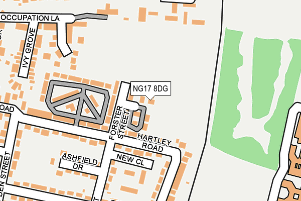
NG17 8DG lies on Pelham Road in Kirkby In Ashfield, Nottingham. NG17 8DG is located in the Greenwood & Summit electoral ward, within the local authority district of Ashfield and the English Parliamentary constituency of Ashfield. The Sub Integrated Care Board (ICB) Location is NHS Nottingham and Nottinghamshire ICB - 52R and the police force is Nottinghamshire. This postcode has been in use since January 1980.


GetTheData
Source: OS OpenMap – Local (Ordnance Survey)
Source: OS VectorMap District (Ordnance Survey)
Licence: Open Government Licence (requires attribution)
| Easting | 450085 |
| Northing | 356493 |
| Latitude | 53.103290 |
| Longitude | -1.253375 |
GetTheData
Source: Open Postcode Geo
Licence: Open Government Licence
| Street | Pelham Road |
| Locality | Kirkby In Ashfield |
| Town/City | Nottingham |
| Country | England |
| Postcode District | NG17 |
➜ See where NG17 is on a map ➜ Where is Kirkby-in-Ashfield? | |
GetTheData
Source: Land Registry Price Paid Data
Licence: Open Government Licence
Elevation or altitude of NG17 8DG as distance above sea level:
| Metres | Feet | |
|---|---|---|
| Elevation | 160m | 525ft |
Elevation is measured from the approximate centre of the postcode, to the nearest point on an OS contour line from OS Terrain 50, which has contour spacing of ten vertical metres.
➜ How high above sea level am I? Find the elevation of your current position using your device's GPS.
GetTheData
Source: Open Postcode Elevation
Licence: Open Government Licence
| Ward | Greenwood & Summit |
| Constituency | Ashfield |
GetTheData
Source: ONS Postcode Database
Licence: Open Government Licence
| Hartley Road | Kirkby In Ashfield | 94m |
| Hartley Road | Kirkby In Ashfield | 106m |
| Harcourt Street | Kirkby In Ashfield | 280m |
| Summit Close (Southwell Lane) | Kirkby In Ashfield | 363m |
| Elm Tree Road (Southwell Lane) | Kirkby In Ashfield | 368m |
| Kirkby in Ashfield Station | 0.4km |
| Sutton Parkway Station | 1.3km |
| Newstead Station | 4.3km |
GetTheData
Source: NaPTAN
Licence: Open Government Licence
| Percentage of properties with Next Generation Access | 100.0% |
| Percentage of properties with Superfast Broadband | 100.0% |
| Percentage of properties with Ultrafast Broadband | 100.0% |
| Percentage of properties with Full Fibre Broadband | 0.0% |
Superfast Broadband is between 30Mbps and 300Mbps
Ultrafast Broadband is > 300Mbps
| Percentage of properties unable to receive 2Mbps | 0.0% |
| Percentage of properties unable to receive 5Mbps | 0.0% |
| Percentage of properties unable to receive 10Mbps | 0.0% |
| Percentage of properties unable to receive 30Mbps | 0.0% |
GetTheData
Source: Ofcom
Licence: Ofcom Terms of Use (requires attribution)
GetTheData
Source: ONS Postcode Database
Licence: Open Government Licence


➜ Get more ratings from the Food Standards Agency
GetTheData
Source: Food Standards Agency
Licence: FSA terms & conditions
| Last Collection | |||
|---|---|---|---|
| Location | Mon-Fri | Sat | Distance |
| Southwell Close | 16:30 | 11:30 | 352m |
| Elm Tree Road | 16:45 | 11:30 | 359m |
| Urban Road | 16:30 | 11:45 | 503m |
GetTheData
Source: Dracos
Licence: Creative Commons Attribution-ShareAlike
The below table lists the International Territorial Level (ITL) codes (formerly Nomenclature of Territorial Units for Statistics (NUTS) codes) and Local Administrative Units (LAU) codes for NG17 8DG:
| ITL 1 Code | Name |
|---|---|
| TLF | East Midlands (England) |
| ITL 2 Code | Name |
| TLF1 | Derbyshire and Nottinghamshire |
| ITL 3 Code | Name |
| TLF15 | North Nottinghamshire |
| LAU 1 Code | Name |
| E07000170 | Ashfield |
GetTheData
Source: ONS Postcode Directory
Licence: Open Government Licence
The below table lists the Census Output Area (OA), Lower Layer Super Output Area (LSOA), and Middle Layer Super Output Area (MSOA) for NG17 8DG:
| Code | Name | |
|---|---|---|
| OA | E00142439 | |
| LSOA | E01027956 | Ashfield 008C |
| MSOA | E02005826 | Ashfield 008 |
GetTheData
Source: ONS Postcode Directory
Licence: Open Government Licence
| NG17 8DJ | Forster Street | 171m |
| NG17 8DL | Ashfield Drive | 186m |
| NG17 8DP | Hartley Road | 190m |
| NG17 8GN | Southwell Close | 201m |
| NG17 8NL | The Hawthorns | 208m |
| NG17 8DE | Harcourt Street | 208m |
| NG17 8DD | Harcourt Street | 242m |
| NG17 8EL | Bannerman Road | 245m |
| NG17 8JL | Ivy Grove | 247m |
| NG17 8FD | Occupation Lane | 248m |
GetTheData
Source: Open Postcode Geo; Land Registry Price Paid Data
Licence: Open Government Licence