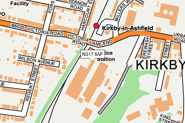
NG17 8AP lies on Urban Road in Kirkby In Ashfield, Nottingham. NG17 8AP is located in the Kirkby Cross & Portland electoral ward, within the local authority district of Ashfield and the English Parliamentary constituency of Ashfield. The Sub Integrated Care Board (ICB) Location is NHS Nottingham and Nottinghamshire ICB - 52R and the police force is Nottinghamshire. This postcode has been in use since January 1980.


GetTheData
Source: OS OpenMap – Local (Ordnance Survey)
Source: OS VectorMap District (Ordnance Survey)
Licence: Open Government Licence (requires attribution)
| Easting | 450064 |
| Northing | 355971 |
| Latitude | 53.098619 |
| Longitude | -1.253767 |
GetTheData
Source: Open Postcode Geo
Licence: Open Government Licence
| Street | Urban Road |
| Locality | Kirkby In Ashfield |
| Town/City | Nottingham |
| Country | England |
| Postcode District | NG17 |
➜ See where NG17 is on a map ➜ Where is Kirkby-in-Ashfield? | |
GetTheData
Source: Land Registry Price Paid Data
Licence: Open Government Licence
Elevation or altitude of NG17 8AP as distance above sea level:
| Metres | Feet | |
|---|---|---|
| Elevation | 150m | 492ft |
Elevation is measured from the approximate centre of the postcode, to the nearest point on an OS contour line from OS Terrain 50, which has contour spacing of ten vertical metres.
➜ How high above sea level am I? Find the elevation of your current position using your device's GPS.
GetTheData
Source: Open Postcode Elevation
Licence: Open Government Licence
| Ward | Kirkby Cross & Portland |
| Constituency | Ashfield |
GetTheData
Source: ONS Postcode Database
Licence: Open Government Licence
| Victoria Road | Kirkby In Ashfield | 136m |
| Harcourt Street | Kirkby In Ashfield | 143m |
| Victoria Road | Kirkby In Ashfield | 214m |
| Aldi (Car Park) | Kirkby In Ashfield | 231m |
| Harcourt Street | Kirkby In Ashfield | 242m |
| Kirkby in Ashfield Station | 0.2km |
| Sutton Parkway Station | 1.8km |
| Newstead Station | 3.8km |
GetTheData
Source: NaPTAN
Licence: Open Government Licence
GetTheData
Source: ONS Postcode Database
Licence: Open Government Licence


➜ Get more ratings from the Food Standards Agency
GetTheData
Source: Food Standards Agency
Licence: FSA terms & conditions
| Last Collection | |||
|---|---|---|---|
| Location | Mon-Fri | Sat | Distance |
| Urban Road | 16:30 | 11:45 | 349m |
| Diamond Avenue | 18:30 | 11:45 | 639m |
| Greenwood Drive | 16:30 | 11:00 | 740m |
GetTheData
Source: Dracos
Licence: Creative Commons Attribution-ShareAlike
The below table lists the International Territorial Level (ITL) codes (formerly Nomenclature of Territorial Units for Statistics (NUTS) codes) and Local Administrative Units (LAU) codes for NG17 8AP:
| ITL 1 Code | Name |
|---|---|
| TLF | East Midlands (England) |
| ITL 2 Code | Name |
| TLF1 | Derbyshire and Nottinghamshire |
| ITL 3 Code | Name |
| TLF15 | North Nottinghamshire |
| LAU 1 Code | Name |
| E07000170 | Ashfield |
GetTheData
Source: ONS Postcode Directory
Licence: Open Government Licence
The below table lists the Census Output Area (OA), Lower Layer Super Output Area (LSOA), and Middle Layer Super Output Area (MSOA) for NG17 8AP:
| Code | Name | |
|---|---|---|
| OA | E00142389 | |
| LSOA | E01027948 | Ashfield 009B |
| MSOA | E02005827 | Ashfield 009 |
GetTheData
Source: ONS Postcode Directory
Licence: Open Government Licence
| NG17 8AQ | Victoria Road | 116m |
| NG17 8AZ | Wilson Avenue | 154m |
| NG17 8BF | Victoria Road | 157m |
| NG17 8AR | Victoria Road | 167m |
| NG17 8AY | Regent Street | 168m |
| NG17 8AN | Erewash Street | 213m |
| NG17 8EH | Forster Street | 217m |
| NG17 8EJ | Vernon Road | 244m |
| NG17 8AJ | Lime Street | 262m |
| NG17 8AX | Victoria Road | 267m |
GetTheData
Source: Open Postcode Geo; Land Registry Price Paid Data
Licence: Open Government Licence