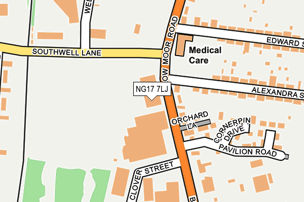
NG17 7LJ is located in the Greenwood & Summit electoral ward, within the local authority district of Ashfield and the English Parliamentary constituency of Ashfield. The Sub Integrated Care Board (ICB) Location is NHS Nottingham and Nottinghamshire ICB - 52R and the police force is Nottinghamshire. This postcode has been in use since January 1980.


GetTheData
Source: OS OpenMap – Local (Ordnance Survey)
Source: OS VectorMap District (Ordnance Survey)
Licence: Open Government Licence (requires attribution)
| Easting | 450480 |
| Northing | 356750 |
| Latitude | 53.105563 |
| Longitude | -1.247435 |
GetTheData
Source: Open Postcode Geo
Licence: Open Government Licence
| Country | England |
| Postcode District | NG17 |
➜ See where NG17 is on a map ➜ Where is Kirkby-in-Ashfield? | |
GetTheData
Source: Land Registry Price Paid Data
Licence: Open Government Licence
Elevation or altitude of NG17 7LJ as distance above sea level:
| Metres | Feet | |
|---|---|---|
| Elevation | 160m | 525ft |
Elevation is measured from the approximate centre of the postcode, to the nearest point on an OS contour line from OS Terrain 50, which has contour spacing of ten vertical metres.
➜ How high above sea level am I? Find the elevation of your current position using your device's GPS.
GetTheData
Source: Open Postcode Elevation
Licence: Open Government Licence
| Ward | Greenwood & Summit |
| Constituency | Ashfield |
GetTheData
Source: ONS Postcode Database
Licence: Open Government Licence
| Field Industrial Estate (Southwell Lane) | Kirkby In Ashfield | 104m |
| Clover Street (Lowmoor Road) | Kirkby In Ashfield | 110m |
| Edward Street (Lowmoor Road) | Kirkby In Ashfield | 124m |
| Alexandra Street | Kirkby In Ashfield | 124m |
| Clover Street (Lowmoor Road) | Kirkby In Ashfield | 134m |
| Kirkby in Ashfield Station | 0.7km |
| Sutton Parkway Station | 1km |
| Newstead Station | 4.3km |
GetTheData
Source: NaPTAN
Licence: Open Government Licence
GetTheData
Source: ONS Postcode Database
Licence: Open Government Licence


➜ Get more ratings from the Food Standards Agency
GetTheData
Source: Food Standards Agency
Licence: FSA terms & conditions
| Last Collection | |||
|---|---|---|---|
| Location | Mon-Fri | Sat | Distance |
| Alexandra Street | 17:00 | 12:00 | 138m |
| Southwell Close | 16:30 | 11:30 | 335m |
| Byron Avenue | 18:30 | 615m | |
GetTheData
Source: Dracos
Licence: Creative Commons Attribution-ShareAlike
The below table lists the International Territorial Level (ITL) codes (formerly Nomenclature of Territorial Units for Statistics (NUTS) codes) and Local Administrative Units (LAU) codes for NG17 7LJ:
| ITL 1 Code | Name |
|---|---|
| TLF | East Midlands (England) |
| ITL 2 Code | Name |
| TLF1 | Derbyshire and Nottinghamshire |
| ITL 3 Code | Name |
| TLF15 | North Nottinghamshire |
| LAU 1 Code | Name |
| E07000170 | Ashfield |
GetTheData
Source: ONS Postcode Directory
Licence: Open Government Licence
The below table lists the Census Output Area (OA), Lower Layer Super Output Area (LSOA), and Middle Layer Super Output Area (MSOA) for NG17 7LJ:
| Code | Name | |
|---|---|---|
| OA | E00142424 | |
| LSOA | E01027952 | Ashfield 008A |
| MSOA | E02005826 | Ashfield 008 |
GetTheData
Source: ONS Postcode Directory
Licence: Open Government Licence
| NG17 7JF | Lowmoor Road | 217m |
| NG17 7JE | Lowmoor Road | 241m |
| NG17 7JH | Alexandra Street | 252m |
| NG17 7JL | Alexandra Street | 269m |
| NG17 8GN | Southwell Close | 335m |
| NG17 8GP | Southwell Close | 345m |
| NG17 7JS | Mary Street | 346m |
| NG17 7JU | Lowmoor Road | 354m |
| NG17 7JA | Lowmoor Road | 371m |
| NG17 7JT | Mary Street | 376m |
GetTheData
Source: Open Postcode Geo; Land Registry Price Paid Data
Licence: Open Government Licence