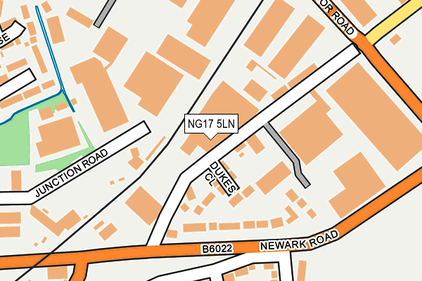
NG17 5LN is located in the Sutton Junction & Harlow Wood electoral ward, within the local authority district of Ashfield and the English Parliamentary constituency of Ashfield. The Sub Integrated Care Board (ICB) Location is NHS Nottingham and Nottinghamshire ICB - 52R and the police force is Nottinghamshire. This postcode has been in use since June 2001.


GetTheData
Source: OS OpenMap – Local (Ordnance Survey)
Source: OS VectorMap District (Ordnance Survey)
Licence: Open Government Licence (requires attribution)
| Easting | 451237 |
| Northing | 358620 |
| Latitude | 53.122299 |
| Longitude | -1.235831 |
GetTheData
Source: Open Postcode Geo
Licence: Open Government Licence
| Country | England |
| Postcode District | NG17 |
➜ See where NG17 is on a map ➜ Where is Sutton in Ashfield? | |
GetTheData
Source: Land Registry Price Paid Data
Licence: Open Government Licence
Elevation or altitude of NG17 5LN as distance above sea level:
| Metres | Feet | |
|---|---|---|
| Elevation | 140m | 459ft |
Elevation is measured from the approximate centre of the postcode, to the nearest point on an OS contour line from OS Terrain 50, which has contour spacing of ten vertical metres.
➜ How high above sea level am I? Find the elevation of your current position using your device's GPS.
GetTheData
Source: Open Postcode Elevation
Licence: Open Government Licence
| Ward | Sutton Junction & Harlow Wood |
| Constituency | Ashfield |
GetTheData
Source: ONS Postcode Database
Licence: Open Government Licence
| Bus Depot (Junction Road) | Sutton Junction | 218m |
| Searby Road | Sutton Junction | 222m |
| Searby Road | Sutton Junction | 267m |
| Hamilton Road (Coxmoor Road) | Sutton Junction | 268m |
| Hamilton Road (Coxmoor Road) | Sutton Junction | 277m |
| Sutton Parkway Station | 1.1km |
| Kirkby in Ashfield Station | 2.7km |
| Mansfield Station | 3.3km |
GetTheData
Source: NaPTAN
Licence: Open Government Licence
GetTheData
Source: ONS Postcode Database
Licence: Open Government Licence


➜ Get more ratings from the Food Standards Agency
GetTheData
Source: Food Standards Agency
Licence: FSA terms & conditions
| Last Collection | |||
|---|---|---|---|
| Location | Mon-Fri | Sat | Distance |
| Kirkby Folly Road | 16:45 | 11:00 | 477m |
| The Hillocks | 17:00 | 11:00 | 889m |
| Station Road | 17:00 | 11:00 | 1,137m |
GetTheData
Source: Dracos
Licence: Creative Commons Attribution-ShareAlike
The below table lists the International Territorial Level (ITL) codes (formerly Nomenclature of Territorial Units for Statistics (NUTS) codes) and Local Administrative Units (LAU) codes for NG17 5LN:
| ITL 1 Code | Name |
|---|---|
| TLF | East Midlands (England) |
| ITL 2 Code | Name |
| TLF1 | Derbyshire and Nottinghamshire |
| ITL 3 Code | Name |
| TLF15 | North Nottinghamshire |
| LAU 1 Code | Name |
| E07000170 | Ashfield |
GetTheData
Source: ONS Postcode Directory
Licence: Open Government Licence
The below table lists the Census Output Area (OA), Lower Layer Super Output Area (LSOA), and Middle Layer Super Output Area (MSOA) for NG17 5LN:
| Code | Name | |
|---|---|---|
| OA | E00173368 | |
| LSOA | E01027972 | Ashfield 004B |
| MSOA | E02005822 | Ashfield 004 |
GetTheData
Source: ONS Postcode Directory
Licence: Open Government Licence
| NG17 5LQ | Dukes Close | 67m |
| NG17 5JP | Newark Road | 122m |
| NG17 5LE | Newark Road | 138m |
| NG17 5LD | Hamilton Road | 170m |
| NG17 5JN | Cardinal Court | 231m |
| NG17 5JW | Wellow Close | 274m |
| NG17 5ES | Hamilton Road | 284m |
| NG17 5JY | Emerald Close | 319m |
| NG17 5GJ | Shepherds Way | 322m |
| NG17 5JU | Sotheby Avenue | 366m |
GetTheData
Source: Open Postcode Geo; Land Registry Price Paid Data
Licence: Open Government Licence