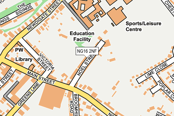
NG16 2NF lies on Noel Street in Kimberley, Nottingham. NG16 2NF is located in the Kimberley electoral ward, within the local authority district of Broxtowe and the English Parliamentary constituency of Broxtowe. The Sub Integrated Care Board (ICB) Location is NHS Nottingham and Nottinghamshire ICB - 52R and the police force is Nottinghamshire. This postcode has been in use since January 1980.


GetTheData
Source: OS OpenMap – Local (Ordnance Survey)
Source: OS VectorMap District (Ordnance Survey)
Licence: Open Government Licence (requires attribution)
| Easting | 450250 |
| Northing | 344729 |
| Latitude | 52.997536 |
| Longitude | -1.252741 |
GetTheData
Source: Open Postcode Geo
Licence: Open Government Licence
| Street | Noel Street |
| Locality | Kimberley |
| Town/City | Nottingham |
| Country | England |
| Postcode District | NG16 |
➜ See where NG16 is on a map ➜ Where is Kimberley? | |
GetTheData
Source: Land Registry Price Paid Data
Licence: Open Government Licence
Elevation or altitude of NG16 2NF as distance above sea level:
| Metres | Feet | |
|---|---|---|
| Elevation | 100m | 328ft |
Elevation is measured from the approximate centre of the postcode, to the nearest point on an OS contour line from OS Terrain 50, which has contour spacing of ten vertical metres.
➜ How high above sea level am I? Find the elevation of your current position using your device's GPS.
GetTheData
Source: Open Postcode Elevation
Licence: Open Government Licence
| Ward | Kimberley |
| Constituency | Broxtowe |
GetTheData
Source: ONS Postcode Database
Licence: Open Government Licence
| Nottingham Road | Kimberley | 202m |
| Library (Main Street) | Kimberley | 214m |
| Nottingham Road | Kimberley | 215m |
| School (Newdigate Street) | Kimberley | 227m |
| Library (Main Street) | Kimberley | 230m |
| Ilkeston Station | 3.5km |
| Bulwell Station | 3.8km |
| Hucknall Station | 5.9km |
GetTheData
Source: NaPTAN
Licence: Open Government Licence
| Percentage of properties with Next Generation Access | 100.0% |
| Percentage of properties with Superfast Broadband | 100.0% |
| Percentage of properties with Ultrafast Broadband | 100.0% |
| Percentage of properties with Full Fibre Broadband | 0.0% |
Superfast Broadband is between 30Mbps and 300Mbps
Ultrafast Broadband is > 300Mbps
| Median download speed | 40.0Mbps |
| Average download speed | 87.0Mbps |
| Maximum download speed | 350.00Mbps |
| Median upload speed | 2.1Mbps |
| Average upload speed | 4.4Mbps |
| Maximum upload speed | 9.77Mbps |
| Percentage of properties unable to receive 2Mbps | 0.0% |
| Percentage of properties unable to receive 5Mbps | 0.0% |
| Percentage of properties unable to receive 10Mbps | 0.0% |
| Percentage of properties unable to receive 30Mbps | 0.0% |
GetTheData
Source: Ofcom
Licence: Ofcom Terms of Use (requires attribution)
Estimated total energy consumption in NG16 2NF by fuel type, 2015.
| Consumption (kWh) | 494,444 |
|---|---|
| Meter count | 37 |
| Mean (kWh/meter) | 13,363 |
| Median (kWh/meter) | 13,097 |
| Consumption (kWh) | 103,840 |
|---|---|
| Meter count | 36 |
| Mean (kWh/meter) | 2,884 |
| Median (kWh/meter) | 2,404 |
GetTheData
Source: Postcode level gas estimates: 2015 (experimental)
Source: Postcode level electricity estimates: 2015 (experimental)
Licence: Open Government Licence
GetTheData
Source: ONS Postcode Database
Licence: Open Government Licence


➜ Get more ratings from the Food Standards Agency
GetTheData
Source: Food Standards Agency
Licence: FSA terms & conditions
| Last Collection | |||
|---|---|---|---|
| Location | Mon-Fri | Sat | Distance |
| Broomhill Road | 16:30 | 11:45 | 130m |
| Kimberley Post Office | 17:15 | 12:00 | 323m |
| Newdigate | 16:30 | 12:15 | 456m |
GetTheData
Source: Dracos
Licence: Creative Commons Attribution-ShareAlike
The below table lists the International Territorial Level (ITL) codes (formerly Nomenclature of Territorial Units for Statistics (NUTS) codes) and Local Administrative Units (LAU) codes for NG16 2NF:
| ITL 1 Code | Name |
|---|---|
| TLF | East Midlands (England) |
| ITL 2 Code | Name |
| TLF1 | Derbyshire and Nottinghamshire |
| ITL 3 Code | Name |
| TLF16 | South Nottinghamshire |
| LAU 1 Code | Name |
| E07000172 | Broxtowe |
GetTheData
Source: ONS Postcode Directory
Licence: Open Government Licence
The below table lists the Census Output Area (OA), Lower Layer Super Output Area (LSOA), and Middle Layer Super Output Area (MSOA) for NG16 2NF:
| Code | Name | |
|---|---|---|
| OA | E00143209 | |
| LSOA | E01028102 | Broxtowe 004A |
| MSOA | E02005853 | Broxtowe 004 |
GetTheData
Source: ONS Postcode Directory
Licence: Open Government Licence
| NG16 2NE | Noel Street | 14m |
| NG16 2NB | Nottingham Road | 167m |
| NG16 2NG | Main Street | 180m |
| NG16 2LZ | Broomhill Road | 180m |
| NG16 2NH | Victoria Street | 187m |
| NG16 1FD | Lime Close | 205m |
| NG16 2NJ | Newdigate Street | 228m |
| NG16 2LY | Main Street | 249m |
| NG16 2WR | The Sidings | 280m |
| NG16 2PB | Greens Lane | 288m |
GetTheData
Source: Open Postcode Geo; Land Registry Price Paid Data
Licence: Open Government Licence