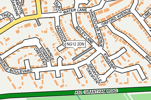
NG12 2DN lies on Bailey Court in Radcliffe On Trent, Nottingham. NG12 2DN is located in the Radcliffe on Trent electoral ward, within the local authority district of Rushcliffe and the English Parliamentary constituency of Rushcliffe. The Sub Integrated Care Board (ICB) Location is NHS Nottingham and Nottinghamshire ICB - 52R and the police force is Nottinghamshire. This postcode has been in use since July 1983.


GetTheData
Source: OS OpenMap – Local (Ordnance Survey)
Source: OS VectorMap District (Ordnance Survey)
Licence: Open Government Licence (requires attribution)
| Easting | 464262 |
| Northing | 338873 |
| Latitude | 52.943408 |
| Longitude | -1.045156 |
GetTheData
Source: Open Postcode Geo
Licence: Open Government Licence
| Street | Bailey Court |
| Locality | Radcliffe On Trent |
| Town/City | Nottingham |
| Country | England |
| Postcode District | NG12 |
➜ See where NG12 is on a map ➜ Where is Radcliffe on Trent? | |
GetTheData
Source: Land Registry Price Paid Data
Licence: Open Government Licence
Elevation or altitude of NG12 2DN as distance above sea level:
| Metres | Feet | |
|---|---|---|
| Elevation | 30m | 98ft |
Elevation is measured from the approximate centre of the postcode, to the nearest point on an OS contour line from OS Terrain 50, which has contour spacing of ten vertical metres.
➜ How high above sea level am I? Find the elevation of your current position using your device's GPS.
GetTheData
Source: Open Postcode Elevation
Licence: Open Government Licence
| Ward | Radcliffe On Trent |
| Constituency | Rushcliffe |
GetTheData
Source: ONS Postcode Database
Licence: Open Government Licence
| Yew Tree Close (Nottingham Road) | Radcliffe On Trent | 268m |
| Yew Tree Close (Nottingham Road) | Radcliffe On Trent | 291m |
| The Green (Main Road) | Radcliffe On Trent | 333m |
| The Green (Main Road) | Radcliffe On Trent | 364m |
| Vicarage Lane (Main Road) | Radcliffe On Trent | 483m |
| Radcliffe (Notts) Station | 0.8km |
| Netherfield Station | 3.1km |
| Carlton Station | 3.3km |
GetTheData
Source: NaPTAN
Licence: Open Government Licence
| Percentage of properties with Next Generation Access | 100.0% |
| Percentage of properties with Superfast Broadband | 100.0% |
| Percentage of properties with Ultrafast Broadband | 100.0% |
| Percentage of properties with Full Fibre Broadband | 0.0% |
Superfast Broadband is between 30Mbps and 300Mbps
Ultrafast Broadband is > 300Mbps
| Percentage of properties unable to receive 2Mbps | 0.0% |
| Percentage of properties unable to receive 5Mbps | 0.0% |
| Percentage of properties unable to receive 10Mbps | 0.0% |
| Percentage of properties unable to receive 30Mbps | 0.0% |
GetTheData
Source: Ofcom
Licence: Ofcom Terms of Use (requires attribution)
GetTheData
Source: ONS Postcode Database
Licence: Open Government Licence


➜ Get more ratings from the Food Standards Agency
GetTheData
Source: Food Standards Agency
Licence: FSA terms & conditions
| Last Collection | |||
|---|---|---|---|
| Location | Mon-Fri | Sat | Distance |
| St Lawrence Boulevard | 17:30 | 11:00 | 77m |
| Water Lane | 17:30 | 10:00 | 156m |
| Radcliffe On Trent Post Office | 17:30 | 11:30 | 588m |
GetTheData
Source: Dracos
Licence: Creative Commons Attribution-ShareAlike
The below table lists the International Territorial Level (ITL) codes (formerly Nomenclature of Territorial Units for Statistics (NUTS) codes) and Local Administrative Units (LAU) codes for NG12 2DN:
| ITL 1 Code | Name |
|---|---|
| TLF | East Midlands (England) |
| ITL 2 Code | Name |
| TLF1 | Derbyshire and Nottinghamshire |
| ITL 3 Code | Name |
| TLF16 | South Nottinghamshire |
| LAU 1 Code | Name |
| E07000176 | Rushcliffe |
GetTheData
Source: ONS Postcode Directory
Licence: Open Government Licence
The below table lists the Census Output Area (OA), Lower Layer Super Output Area (LSOA), and Middle Layer Super Output Area (MSOA) for NG12 2DN:
| Code | Name | |
|---|---|---|
| OA | E00144676 | |
| LSOA | E01028394 | Rushcliffe 003B |
| MSOA | E02005908 | Rushcliffe 003 |
GetTheData
Source: ONS Postcode Directory
Licence: Open Government Licence
| NG12 2DA | Bailey Lane | 64m |
| NG12 2BX | Paddock Close | 83m |
| NG12 2DY | St Lawrence Boulevard | 102m |
| NG12 2EJ | Saskatoon Close | 108m |
| NG12 2EG | Bailey Lane | 111m |
| NG12 2ES | Vancouver Avenue | 126m |
| NG12 2EF | Granville Crescent | 127m |
| NG12 2EL | Regina Close | 129m |
| NG12 2BY | Water Lane | 150m |
| NG12 2EN | Portage Close | 182m |
GetTheData
Source: Open Postcode Geo; Land Registry Price Paid Data
Licence: Open Government Licence