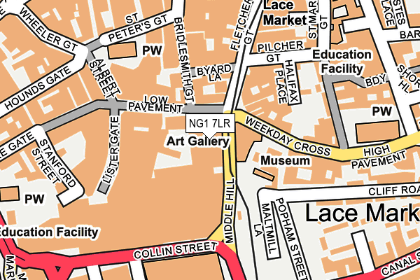
NG1 7LR is located in the Castle electoral ward, within the unitary authority of Nottingham and the English Parliamentary constituency of Nottingham South. The Sub Integrated Care Board (ICB) Location is NHS Nottingham and Nottinghamshire ICB - 52R and the police force is Nottinghamshire. This postcode has been in use since January 1980.


GetTheData
Source: OS OpenMap – Local (Ordnance Survey)
Source: OS VectorMap District (Ordnance Survey)
Licence: Open Government Licence (requires attribution)
| Easting | 457436 |
| Northing | 339611 |
| Latitude | 52.950834 |
| Longitude | -1.146588 |
GetTheData
Source: Open Postcode Geo
Licence: Open Government Licence
| Country | England |
| Postcode District | NG1 |
➜ See where NG1 is on a map ➜ Where is Nottingham? | |
GetTheData
Source: Land Registry Price Paid Data
Licence: Open Government Licence
Elevation or altitude of NG1 7LR as distance above sea level:
| Metres | Feet | |
|---|---|---|
| Elevation | 30m | 98ft |
Elevation is measured from the approximate centre of the postcode, to the nearest point on an OS contour line from OS Terrain 50, which has contour spacing of ten vertical metres.
➜ How high above sea level am I? Find the elevation of your current position using your device's GPS.
GetTheData
Source: Open Postcode Elevation
Licence: Open Government Licence
| Ward | Castle |
| Constituency | Nottingham South |
GetTheData
Source: ONS Postcode Database
Licence: Open Government Licence
| Collin Street | Nottingham | 119m |
| Collin Street | Nottingham | 127m |
| Collin Street | Nottingham | 136m |
| Collin Street | Nottingham | 145m |
| Collin Street | Nottingham | 202m |
| Lace Market Tram Stop (Fletcher Gate) | Nottingham | 267m |
| Old Market Square Tram Stop (South Parade) | Nottingham | 372m |
| Nottingham Station Tram Stop (N/A) | Nottingham | 445m |
| Royal Centre Tram Stop (Wollaton Street) | Nottingham | 615m |
| Queens Walk Tram Stop (Queens Walk) | Meadows | 932m |
| Nottingham Station | 0.4km |
| Netherfield Station | 4.6km |
| Carlton Station | 4.8km |
GetTheData
Source: NaPTAN
Licence: Open Government Licence
GetTheData
Source: ONS Postcode Database
Licence: Open Government Licence


➜ Get more ratings from the Food Standards Agency
GetTheData
Source: Food Standards Agency
Licence: FSA terms & conditions
| Last Collection | |||
|---|---|---|---|
| Location | Mon-Fri | Sat | Distance |
| Low Pavement | 18:45 | 12:00 | 120m |
| Low Pavement | 18:45 | 12:00 | 121m |
| High Pavement | 18:30 | 12:00 | 190m |
GetTheData
Source: Dracos
Licence: Creative Commons Attribution-ShareAlike
The below table lists the International Territorial Level (ITL) codes (formerly Nomenclature of Territorial Units for Statistics (NUTS) codes) and Local Administrative Units (LAU) codes for NG1 7LR:
| ITL 1 Code | Name |
|---|---|
| TLF | East Midlands (England) |
| ITL 2 Code | Name |
| TLF1 | Derbyshire and Nottinghamshire |
| ITL 3 Code | Name |
| TLF14 | Nottingham |
| LAU 1 Code | Name |
| E06000018 | Nottingham |
GetTheData
Source: ONS Postcode Directory
Licence: Open Government Licence
The below table lists the Census Output Area (OA), Lower Layer Super Output Area (LSOA), and Middle Layer Super Output Area (MSOA) for NG1 7LR:
| Code | Name | |
|---|---|---|
| OA | E00173480 | |
| LSOA | E01033400 | Nottingham 039B |
| MSOA | E02006904 | Nottingham 039 |
GetTheData
Source: ONS Postcode Directory
Licence: Open Government Licence
| NG1 7DG | Low Pavement | 93m |
| NG1 1HF | High Pavement | 107m |
| NG1 2GB | Weekday Cross | 109m |
| NG1 7DE | Lister Gate | 123m |
| NG1 1QF | Pilcher Gate | 146m |
| NG1 1QL | Halifax Place | 146m |
| NG1 1HN | High Pavement | 159m |
| NG1 1QN | Halifax Place | 170m |
| NG1 2GR | Bridlesmith Gate | 178m |
| NG1 1QA | St Marys Gate | 179m |
GetTheData
Source: Open Postcode Geo; Land Registry Price Paid Data
Licence: Open Government Licence
| Stanford Street | At Any Time | 201m |
| Stanford Street | 8am-8pm | 207m |
| Stanford Street | At Any Time | 213m |
GetTheData
Source: Disabled parking spaces, Nottingham City Council, 19/02/2013
Licence: Open Government Licence