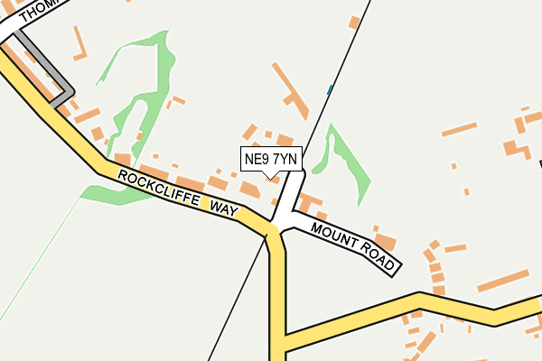
NE9 7YN lies on Rockcliffe Way in Eighton Banks, Gateshead. NE9 7YN is located in the Lamesley electoral ward, within the metropolitan district of Gateshead and the English Parliamentary constituency of Blaydon. The Sub Integrated Care Board (ICB) Location is NHS North East and North Cumbria ICB - 13T and the police force is Northumbria. This postcode has been in use since January 1980.


GetTheData
Source: OS OpenMap – Local (Ordnance Survey)
Source: OS VectorMap District (Ordnance Survey)
Licence: Open Government Licence (requires attribution)
| Easting | 428122 |
| Northing | 557942 |
| Latitude | 54.915403 |
| Longitude | -1.562853 |
GetTheData
Source: Open Postcode Geo
Licence: Open Government Licence
| Street | Rockcliffe Way |
| Locality | Eighton Banks |
| Town/City | Gateshead |
| Country | England |
| Postcode District | NE9 |
➜ See where NE9 is on a map ➜ Where is Gateshead? | |
GetTheData
Source: Land Registry Price Paid Data
Licence: Open Government Licence
Elevation or altitude of NE9 7YN as distance above sea level:
| Metres | Feet | |
|---|---|---|
| Elevation | 140m | 459ft |
Elevation is measured from the approximate centre of the postcode, to the nearest point on an OS contour line from OS Terrain 50, which has contour spacing of ten vertical metres.
➜ How high above sea level am I? Find the elevation of your current position using your device's GPS.
GetTheData
Source: Open Postcode Elevation
Licence: Open Government Licence
| Ward | Lamesley |
| Constituency | Blaydon |
GetTheData
Source: ONS Postcode Database
Licence: Open Government Licence
NORTH BANK BUNGALOW, ROCKCLIFFE WAY, EIGHTON BANKS, GATESHEAD, NE9 7YN 2018 3 OCT £270,000 |
GetTheData
Source: HM Land Registry Price Paid Data
Licence: Contains HM Land Registry data © Crown copyright and database right 2025. This data is licensed under the Open Government Licence v3.0.
| Rockcliffe Way-lambton Arms (Rockcliffe Way) | Eighton Banks | 113m |
| Mount Lane-mount Lonnen (Mount Lane) | Eighton Banks | 209m |
| Eighton Road-nursery (Eighton Road) | Eighton Banks | 235m |
| Mount Lane-mount Lonnen (Mount Lane) | Eighton Banks | 249m |
| Rockcliffe Way-prospect Terrace (Rockcliffe Way) | Eighton Banks | 269m |
| Heworth Station | 4.1km |
GetTheData
Source: NaPTAN
Licence: Open Government Licence
| Percentage of properties with Next Generation Access | 33.3% |
| Percentage of properties with Superfast Broadband | 33.3% |
| Percentage of properties with Ultrafast Broadband | 33.3% |
| Percentage of properties with Full Fibre Broadband | 0.0% |
Superfast Broadband is between 30Mbps and 300Mbps
Ultrafast Broadband is > 300Mbps
| Percentage of properties unable to receive 2Mbps | 0.0% |
| Percentage of properties unable to receive 5Mbps | 50.0% |
| Percentage of properties unable to receive 10Mbps | 66.7% |
| Percentage of properties unable to receive 30Mbps | 66.7% |
GetTheData
Source: Ofcom
Licence: Ofcom Terms of Use (requires attribution)
GetTheData
Source: ONS Postcode Database
Licence: Open Government Licence


➜ Get more ratings from the Food Standards Agency
GetTheData
Source: Food Standards Agency
Licence: FSA terms & conditions
| Last Collection | |||
|---|---|---|---|
| Location | Mon-Fri | Sat | Distance |
| The Mount | 16:00 | 10:30 | 53m |
| Sandy Lane | 17:30 | 10:30 | 381m |
| Springwell Post Office | 16:30 | 10:30 | 761m |
GetTheData
Source: Dracos
Licence: Creative Commons Attribution-ShareAlike
The below table lists the International Territorial Level (ITL) codes (formerly Nomenclature of Territorial Units for Statistics (NUTS) codes) and Local Administrative Units (LAU) codes for NE9 7YN:
| ITL 1 Code | Name |
|---|---|
| TLC | North East (England) |
| ITL 2 Code | Name |
| TLC2 | Northumberland, and Tyne and Wear |
| ITL 3 Code | Name |
| TLC22 | Tyneside |
| LAU 1 Code | Name |
| E08000037 | Gateshead |
GetTheData
Source: ONS Postcode Directory
Licence: Open Government Licence
The below table lists the Census Output Area (OA), Lower Layer Super Output Area (LSOA), and Middle Layer Super Output Area (MSOA) for NE9 7YN:
| Code | Name | |
|---|---|---|
| OA | E00041707 | |
| LSOA | E01008225 | Gateshead 021D |
| MSOA | E02001702 | Gateshead 021 |
GetTheData
Source: ONS Postcode Directory
Licence: Open Government Licence
| NE9 7YJ | Rockcliffe Way | 72m |
| NE9 7XR | Rockcliffe Way | 122m |
| NE9 7YP | The Mount | 161m |
| NE9 7YH | 194m | |
| NE9 7YE | Prospect Terrace | 266m |
| NE9 7UZ | Mount Lonnen | 298m |
| NE9 7YA | Thomas Street | 300m |
| NE9 7YB | Sandy Lane | 340m |
| NE9 7XY | Hawthorn Terrace | 356m |
| NE9 7XU | Walmer Terrace | 447m |
GetTheData
Source: Open Postcode Geo; Land Registry Price Paid Data
Licence: Open Government Licence