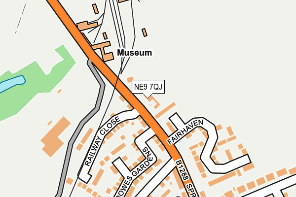
NE9 7QJ lies on Springwell Road in Springwell Village, Gateshead. NE9 7QJ is located in the Washington West electoral ward, within the metropolitan district of Sunderland and the English Parliamentary constituency of Washington and Sunderland West. The Sub Integrated Care Board (ICB) Location is NHS North East and North Cumbria ICB - 00P and the police force is Northumbria. This postcode has been in use since January 1980.


GetTheData
Source: OS OpenMap – Local (Ordnance Survey)
Source: OS VectorMap District (Ordnance Survey)
Licence: Open Government Licence (requires attribution)
| Easting | 428575 |
| Northing | 558719 |
| Latitude | 54.922352 |
| Longitude | -1.555698 |
GetTheData
Source: Open Postcode Geo
Licence: Open Government Licence
| Street | Springwell Road |
| Locality | Springwell Village |
| Town/City | Gateshead |
| Country | England |
| Postcode District | NE9 |
➜ See where NE9 is on a map ➜ Where is Springwell? | |
GetTheData
Source: Land Registry Price Paid Data
Licence: Open Government Licence
Elevation or altitude of NE9 7QJ as distance above sea level:
| Metres | Feet | |
|---|---|---|
| Elevation | 140m | 459ft |
Elevation is measured from the approximate centre of the postcode, to the nearest point on an OS contour line from OS Terrain 50, which has contour spacing of ten vertical metres.
➜ How high above sea level am I? Find the elevation of your current position using your device's GPS.
GetTheData
Source: Open Postcode Elevation
Licence: Open Government Licence
| Ward | Washington West |
| Constituency | Washington And Sunderland West |
GetTheData
Source: ONS Postcode Database
Licence: Open Government Licence
2007 1 JUN £600,000 |
2006 17 AUG £371,544 |
2003 19 SEP £429,000 |
2003 2 JUL £223,950 |
1996 13 SEP £169,000 |
DERWENT, SPRINGWELL ROAD, SPRINGWELL VILLAGE, GATESHEAD, NE9 7QJ 1996 9 SEP £74,000 |
GetTheData
Source: HM Land Registry Price Paid Data
Licence: Contains HM Land Registry data © Crown copyright and database right 2025. This data is licensed under the Open Government Licence v3.0.
| Springwell Road-bowes Railway (Springwell Road) | Springwell | 26m |
| Springwell Road-bowes Railway (Springwell Road) | Springwell | 48m |
| Springwell Village (Springwell Lane) | Springwell | 177m |
| Springwell Village (Springwell Lane) | Springwell | 234m |
| Uplands Way | Springwell | 394m |
| Heworth Station | 3.3km |
GetTheData
Source: NaPTAN
Licence: Open Government Licence
| Percentage of properties with Next Generation Access | 100.0% |
| Percentage of properties with Superfast Broadband | 100.0% |
| Percentage of properties with Ultrafast Broadband | 100.0% |
| Percentage of properties with Full Fibre Broadband | 0.0% |
Superfast Broadband is between 30Mbps and 300Mbps
Ultrafast Broadband is > 300Mbps
| Percentage of properties unable to receive 2Mbps | 0.0% |
| Percentage of properties unable to receive 5Mbps | 0.0% |
| Percentage of properties unable to receive 10Mbps | 0.0% |
| Percentage of properties unable to receive 30Mbps | 0.0% |
GetTheData
Source: Ofcom
Licence: Ofcom Terms of Use (requires attribution)
GetTheData
Source: ONS Postcode Database
Licence: Open Government Licence


➜ Get more ratings from the Food Standards Agency
GetTheData
Source: Food Standards Agency
Licence: FSA terms & conditions
| Last Collection | |||
|---|---|---|---|
| Location | Mon-Fri | Sat | Distance |
| Springwell Post Office | 16:30 | 10:30 | 394m |
| Peareth Hall Road | 17:30 | 10:30 | 710m |
| Cypress Road | 17:30 | 10:30 | 838m |
GetTheData
Source: Dracos
Licence: Creative Commons Attribution-ShareAlike
The below table lists the International Territorial Level (ITL) codes (formerly Nomenclature of Territorial Units for Statistics (NUTS) codes) and Local Administrative Units (LAU) codes for NE9 7QJ:
| ITL 1 Code | Name |
|---|---|
| TLC | North East (England) |
| ITL 2 Code | Name |
| TLC2 | Northumberland, and Tyne and Wear |
| ITL 3 Code | Name |
| TLC23 | Sunderland |
| LAU 1 Code | Name |
| E08000024 | Sunderland |
GetTheData
Source: ONS Postcode Directory
Licence: Open Government Licence
The below table lists the Census Output Area (OA), Lower Layer Super Output Area (LSOA), and Middle Layer Super Output Area (MSOA) for NE9 7QJ:
| Code | Name | |
|---|---|---|
| OA | E00045075 | |
| LSOA | E01008877 | Sunderland 007D |
| MSOA | E02001797 | Sunderland 007 |
GetTheData
Source: ONS Postcode Directory
Licence: Open Government Licence
| NE9 7QW | Somerford | 40m |
| NE9 7RG | Railway Close | 115m |
| NE9 7NZ | Bowes Gardens | 138m |
| NE9 7QZ | Fairhaven | 169m |
| NE9 7QG | Badger Mews | 205m |
| NE9 7QL | Meadowfield | 258m |
| NE9 7QN | Windsor Terrace | 268m |
| NE9 7RF | Park View | 269m |
| NE9 7SX | Oakwood Close | 293m |
| NE9 7NQ | Uplands Way | 296m |
GetTheData
Source: Open Postcode Geo; Land Registry Price Paid Data
Licence: Open Government Licence