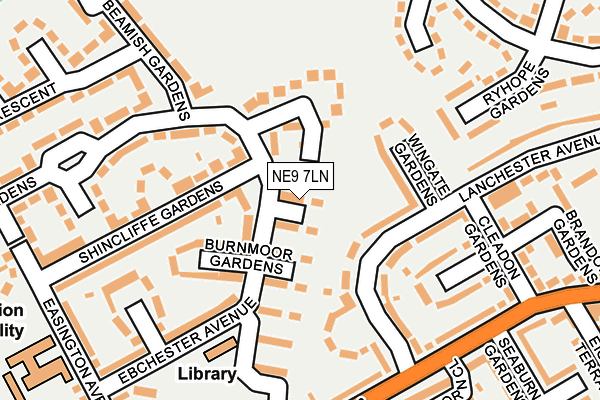
NE9 7LN lies on Waskerley Gardens in Gateshead. NE9 7LN is located in the High Fell electoral ward, within the metropolitan district of Gateshead and the English Parliamentary constituency of Gateshead. The Sub Integrated Care Board (ICB) Location is NHS North East and North Cumbria ICB - 13T and the police force is Northumbria. This postcode has been in use since July 1986.


GetTheData
Source: OS OpenMap – Local (Ordnance Survey)
Source: OS VectorMap District (Ordnance Survey)
Licence: Open Government Licence (requires attribution)
| Easting | 427709 |
| Northing | 559415 |
| Latitude | 54.928655 |
| Longitude | -1.569142 |
GetTheData
Source: Open Postcode Geo
Licence: Open Government Licence
| Street | Waskerley Gardens |
| Town/City | Gateshead |
| Country | England |
| Postcode District | NE9 |
➜ See where NE9 is on a map ➜ Where is Gateshead? | |
GetTheData
Source: Land Registry Price Paid Data
Licence: Open Government Licence
Elevation or altitude of NE9 7LN as distance above sea level:
| Metres | Feet | |
|---|---|---|
| Elevation | 140m | 459ft |
Elevation is measured from the approximate centre of the postcode, to the nearest point on an OS contour line from OS Terrain 50, which has contour spacing of ten vertical metres.
➜ How high above sea level am I? Find the elevation of your current position using your device's GPS.
GetTheData
Source: Open Postcode Elevation
Licence: Open Government Licence
| Ward | High Fell |
| Constituency | Gateshead |
GetTheData
Source: ONS Postcode Database
Licence: Open Government Licence
| Lanchester Ave-springwell Rd (Lanchester Avenue) | Springwell Estate | 159m |
| Lanchester Ave-springwell Rd (Lanchester Avenue) | Springwell Estate | 172m |
| Lanchester Ave-cleadon Gdns (Lanchester Avenue) | Springwell Estate | 208m |
| Springwell Rd-felldyke School (Springwell Road) | Springwell Estate | 215m |
| Springwell Road-health Centre (Springwell Road) | Wrekenton | 293m |
| Heworth Station | 2.7km |
| Dunston Station | 5.2km |
| Newcastle Station | 5.4km |
GetTheData
Source: NaPTAN
Licence: Open Government Licence
| Percentage of properties with Next Generation Access | 100.0% |
| Percentage of properties with Superfast Broadband | 100.0% |
| Percentage of properties with Ultrafast Broadband | 100.0% |
| Percentage of properties with Full Fibre Broadband | 0.0% |
Superfast Broadband is between 30Mbps and 300Mbps
Ultrafast Broadband is > 300Mbps
| Median download speed | 50.0Mbps |
| Average download speed | 108.4Mbps |
| Maximum download speed | 350.00Mbps |
| Median upload speed | 4.4Mbps |
| Average upload speed | 4.9Mbps |
| Maximum upload speed | 7.09Mbps |
| Percentage of properties unable to receive 2Mbps | 0.0% |
| Percentage of properties unable to receive 5Mbps | 0.0% |
| Percentage of properties unable to receive 10Mbps | 0.0% |
| Percentage of properties unable to receive 30Mbps | 0.0% |
GetTheData
Source: Ofcom
Licence: Ofcom Terms of Use (requires attribution)
Estimated total energy consumption in NE9 7LN by fuel type, 2015.
| Consumption (kWh) | 131,164 |
|---|---|
| Meter count | 12 |
| Mean (kWh/meter) | 10,930 |
| Median (kWh/meter) | 12,223 |
| Consumption (kWh) | 42,284 |
|---|---|
| Meter count | 12 |
| Mean (kWh/meter) | 3,524 |
| Median (kWh/meter) | 3,590 |
GetTheData
Source: Postcode level gas estimates: 2015 (experimental)
Source: Postcode level electricity estimates: 2015 (experimental)
Licence: Open Government Licence
GetTheData
Source: ONS Postcode Database
Licence: Open Government Licence


➜ Get more ratings from the Food Standards Agency
GetTheData
Source: Food Standards Agency
Licence: FSA terms & conditions
| Last Collection | |||
|---|---|---|---|
| Location | Mon-Fri | Sat | Distance |
| Springwell Road | 16:00 | 10:30 | 230m |
| Victoria Terrace | 16:30 | 10:30 | 479m |
| Aycliffe Avenue Post Office | 17:15 | 12:00 | 512m |
GetTheData
Source: Dracos
Licence: Creative Commons Attribution-ShareAlike
The below table lists the International Territorial Level (ITL) codes (formerly Nomenclature of Territorial Units for Statistics (NUTS) codes) and Local Administrative Units (LAU) codes for NE9 7LN:
| ITL 1 Code | Name |
|---|---|
| TLC | North East (England) |
| ITL 2 Code | Name |
| TLC2 | Northumberland, and Tyne and Wear |
| ITL 3 Code | Name |
| TLC22 | Tyneside |
| LAU 1 Code | Name |
| E08000037 | Gateshead |
GetTheData
Source: ONS Postcode Directory
Licence: Open Government Licence
The below table lists the Census Output Area (OA), Lower Layer Super Output Area (LSOA), and Middle Layer Super Output Area (MSOA) for NE9 7LN:
| Code | Name | |
|---|---|---|
| OA | E00041679 | |
| LSOA | E01008218 | Gateshead 021A |
| MSOA | E02001702 | Gateshead 021 |
GetTheData
Source: ONS Postcode Directory
Licence: Open Government Licence
| NE9 7LQ | Wolviston Gardens | 28m |
| NE9 7LE | Waldridge Gardens | 74m |
| NE9 7LS | Wolsingham Gardens | 86m |
| NE9 7BE | Wingate Gardens | 98m |
| NE9 7LR | Burnmoor Gardens | 106m |
| NE9 7AJ | Lanchester Avenue | 110m |
| NE9 7BH | Trimdon Grove | 143m |
| NE9 7LP | Ebchester Avenue | 153m |
| NE9 7LJ | Shincliffe Gardens | 158m |
| NE9 7LT | Westwood Gardens | 171m |
GetTheData
Source: Open Postcode Geo; Land Registry Price Paid Data
Licence: Open Government Licence