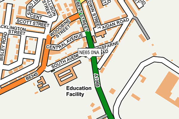
NE65 0NA lies on Albert Street in Amble, Morpeth. NE65 0NA is located in the Amble West with Warkworth electoral ward, within the unitary authority of Northumberland and the English Parliamentary constituency of Berwick-upon-Tweed. The Sub Integrated Care Board (ICB) Location is NHS North East and North Cumbria ICB - 00L and the police force is Northumbria. This postcode has been in use since January 1980.


GetTheData
Source: OS OpenMap – Local (Ordnance Survey)
Source: OS VectorMap District (Ordnance Survey)
Licence: Open Government Licence (requires attribution)
| Easting | 426326 |
| Northing | 604023 |
| Latitude | 55.329565 |
| Longitude | -1.586605 |
GetTheData
Source: Open Postcode Geo
Licence: Open Government Licence
| Street | Albert Street |
| Locality | Amble |
| Town/City | Morpeth |
| Country | England |
| Postcode District | NE65 |
➜ See where NE65 is on a map ➜ Where is Amble? | |
GetTheData
Source: Land Registry Price Paid Data
Licence: Open Government Licence
Elevation or altitude of NE65 0NA as distance above sea level:
| Metres | Feet | |
|---|---|---|
| Elevation | 10m | 33ft |
Elevation is measured from the approximate centre of the postcode, to the nearest point on an OS contour line from OS Terrain 50, which has contour spacing of ten vertical metres.
➜ How high above sea level am I? Find the elevation of your current position using your device's GPS.
GetTheData
Source: Open Postcode Elevation
Licence: Open Government Licence
| Ward | Amble West With Warkworth |
| Constituency | Berwick-upon-tweed |
GetTheData
Source: ONS Postcode Database
Licence: Open Government Licence
WINDMILL COTTAGE, ALBERT STREET, AMBLE, MORPETH, NE65 0NA 1998 31 JUL £68,500 |
GetTheData
Source: HM Land Registry Price Paid Data
Licence: Contains HM Land Registry data © Crown copyright and database right 2025. This data is licensed under the Open Government Licence v3.0.
| Woodbine Street | Amble By The Sea | 152m |
| Acklington Road | Amble By The Sea | 258m |
| High Street | Amble By The Sea | 352m |
| High Street | Amble By The Sea | 364m |
| Fourways (Church Street) | Amble By The Sea | 451m |
| Acklington Station | 4.8km |
GetTheData
Source: NaPTAN
Licence: Open Government Licence
GetTheData
Source: ONS Postcode Database
Licence: Open Government Licence


➜ Get more ratings from the Food Standards Agency
GetTheData
Source: Food Standards Agency
Licence: FSA terms & conditions
| Last Collection | |||
|---|---|---|---|
| Location | Mon-Fri | Sat | Distance |
| Acklington Road | 17:00 | 09:00 | 171m |
| High Street | 16:30 | 09:00 | 344m |
| Amble Industrial Estate | 16:30 | 09:00 | 418m |
GetTheData
Source: Dracos
Licence: Creative Commons Attribution-ShareAlike
The below table lists the International Territorial Level (ITL) codes (formerly Nomenclature of Territorial Units for Statistics (NUTS) codes) and Local Administrative Units (LAU) codes for NE65 0NA:
| ITL 1 Code | Name |
|---|---|
| TLC | North East (England) |
| ITL 2 Code | Name |
| TLC2 | Northumberland, and Tyne and Wear |
| ITL 3 Code | Name |
| TLC21 | Northumberland |
| LAU 1 Code | Name |
| E06000057 | Northumberland |
GetTheData
Source: ONS Postcode Directory
Licence: Open Government Licence
The below table lists the Census Output Area (OA), Lower Layer Super Output Area (LSOA), and Middle Layer Super Output Area (MSOA) for NE65 0NA:
| Code | Name | |
|---|---|---|
| OA | E00139230 | |
| LSOA | E01027364 | Northumberland 006D |
| MSOA | E02005704 | Northumberland 006 |
GetTheData
Source: ONS Postcode Directory
Licence: Open Government Licence
| NE65 0NQ | Central Avenue | 83m |
| NE65 0ND | South Avenue | 84m |
| NE65 0LY | Albert Street | 98m |
| NE65 0EH | Lindisfarne Road | 112m |
| NE65 0LZ | Albert Street | 141m |
| NE65 0EQ | Aidan Road | 154m |
| NE65 0NH | Woodbine Street | 158m |
| NE65 0EF | Edwin Street | 162m |
| NE65 0NF | Acklington Road | 165m |
| NE65 0NJ | Hope Terrace | 185m |
GetTheData
Source: Open Postcode Geo; Land Registry Price Paid Data
Licence: Open Government Licence