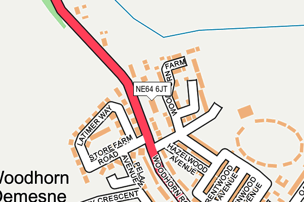
NE64 6JT lies on Woodhorn Road in Newbiggin-by-the-sea. NE64 6JT is located in the Newbiggin Central and East electoral ward, within the unitary authority of Northumberland and the English Parliamentary constituency of Wansbeck. The Sub Integrated Care Board (ICB) Location is NHS North East and North Cumbria ICB - 00L and the police force is Northumbria. This postcode has been in use since January 1980.


GetTheData
Source: OS OpenMap – Local (Ordnance Survey)
Source: OS VectorMap District (Ordnance Survey)
Licence: Open Government Licence (requires attribution)
| Easting | 430549 |
| Northing | 588501 |
| Latitude | 55.189849 |
| Longitude | -1.521723 |
GetTheData
Source: Open Postcode Geo
Licence: Open Government Licence
| Street | Woodhorn Road |
| Town/City | Newbiggin-by-the-sea |
| Country | England |
| Postcode District | NE64 |
➜ See where NE64 is on a map ➜ Where is Newbiggin-by-the-Sea? | |
GetTheData
Source: Land Registry Price Paid Data
Licence: Open Government Licence
Elevation or altitude of NE64 6JT as distance above sea level:
| Metres | Feet | |
|---|---|---|
| Elevation | 20m | 66ft |
Elevation is measured from the approximate centre of the postcode, to the nearest point on an OS contour line from OS Terrain 50, which has contour spacing of ten vertical metres.
➜ How high above sea level am I? Find the elevation of your current position using your device's GPS.
GetTheData
Source: Open Postcode Elevation
Licence: Open Government Licence
| Ward | Newbiggin Central And East |
| Constituency | Wansbeck |
GetTheData
Source: ONS Postcode Database
Licence: Open Government Licence
SEATON COTTAGE, WOODHORN ROAD, NEWBIGGIN-BY-THE-SEA, NE64 6JT 2010 26 FEB £165,500 |
➜ Newbiggin-by-the-Sea house prices
GetTheData
Source: HM Land Registry Price Paid Data
Licence: Contains HM Land Registry data © Crown copyright and database right 2025. This data is licensed under the Open Government Licence v3.0.
| Woodhorn Demesne (A197) | Newbiggin-by-the-sea | 69m |
| Woodhorn Demesne (A197) | Newbiggin-by-the-sea | 80m |
| Storey Crescent (Woodhorn Road) | Newbiggin-by-the-sea | 242m |
| Storey Crescent (Woodhorn Road) | Newbiggin-by-the-sea | 276m |
| Sports Centre (Woodhorn Road) | Newbiggin-by-the-sea | 532m |
GetTheData
Source: NaPTAN
Licence: Open Government Licence
| Percentage of properties with Next Generation Access | 100.0% |
| Percentage of properties with Superfast Broadband | 100.0% |
| Percentage of properties with Ultrafast Broadband | 0.0% |
| Percentage of properties with Full Fibre Broadband | 0.0% |
Superfast Broadband is between 30Mbps and 300Mbps
Ultrafast Broadband is > 300Mbps
| Percentage of properties unable to receive 2Mbps | 0.0% |
| Percentage of properties unable to receive 5Mbps | 0.0% |
| Percentage of properties unable to receive 10Mbps | 0.0% |
| Percentage of properties unable to receive 30Mbps | 0.0% |
GetTheData
Source: Ofcom
Licence: Ofcom Terms of Use (requires attribution)
GetTheData
Source: ONS Postcode Database
Licence: Open Government Licence


➜ Get more ratings from the Food Standards Agency
GetTheData
Source: Food Standards Agency
Licence: FSA terms & conditions
| Last Collection | |||
|---|---|---|---|
| Location | Mon-Fri | Sat | Distance |
| Woodhorn Road | 16:45 | 10:45 | 208m |
| Woodlea | 16:45 | 10:45 | 604m |
| Front Street | 16:30 | 11:00 | 803m |
GetTheData
Source: Dracos
Licence: Creative Commons Attribution-ShareAlike
The below table lists the International Territorial Level (ITL) codes (formerly Nomenclature of Territorial Units for Statistics (NUTS) codes) and Local Administrative Units (LAU) codes for NE64 6JT:
| ITL 1 Code | Name |
|---|---|
| TLC | North East (England) |
| ITL 2 Code | Name |
| TLC2 | Northumberland, and Tyne and Wear |
| ITL 3 Code | Name |
| TLC21 | Northumberland |
| LAU 1 Code | Name |
| E06000057 | Northumberland |
GetTheData
Source: ONS Postcode Directory
Licence: Open Government Licence
The below table lists the Census Output Area (OA), Lower Layer Super Output Area (LSOA), and Middle Layer Super Output Area (MSOA) for NE64 6JT:
| Code | Name | |
|---|---|---|
| OA | E00140178 | |
| LSOA | E01027542 | Northumberland 009B |
| MSOA | E02005734 | Northumberland 009 |
GetTheData
Source: ONS Postcode Directory
Licence: Open Government Licence
| NE64 6AH | Woodhorn Farm | 59m |
| NE64 6JR | Latimer Way | 123m |
| NE64 6JW | Holmwood Avenue | 131m |
| NE64 6LB | Store Farm Road | 141m |
| NE64 6JB | Woodhorn Crescent | 145m |
| NE64 6JN | Hazelwood Avenue | 151m |
| NE64 6JA | Woodhorn Road | 160m |
| NE64 6LD | Pelaw Avenue | 172m |
| NE64 6JH | Brentwood Avenue | 220m |
| NE64 6JU | Smallholdings | 231m |
GetTheData
Source: Open Postcode Geo; Land Registry Price Paid Data
Licence: Open Government Licence