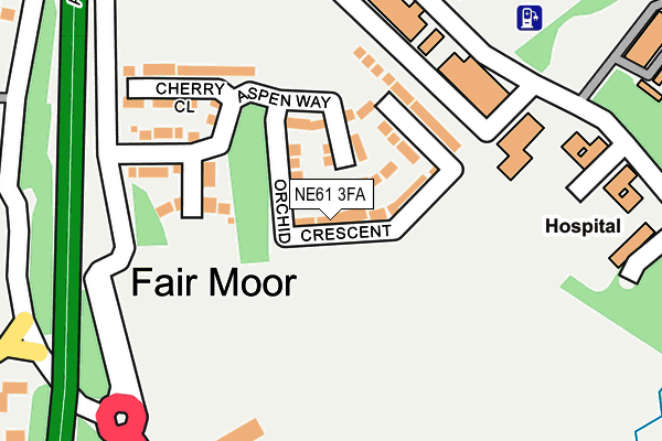
NE61 3FA is located in the Pegswood electoral ward, within the unitary authority of Northumberland and the English Parliamentary constituency of Wansbeck. The Sub Integrated Care Board (ICB) Location is NHS North East and North Cumbria ICB - 00L and the police force is Northumbria. This postcode has been in use since January 2017.


GetTheData
Source: OS OpenMap – Local (Ordnance Survey)
Source: OS VectorMap District (Ordnance Survey)
Licence: Open Government Licence (requires attribution)
| Easting | 418452 |
| Northing | 587652 |
| Latitude | 55.182822 |
| Longitude | -1.711789 |
GetTheData
Source: Open Postcode Geo
Licence: Open Government Licence
| Country | England |
| Postcode District | NE61 |
➜ See where NE61 is on a map ➜ Where is Fair Moor? | |
GetTheData
Source: Land Registry Price Paid Data
Licence: Open Government Licence
Elevation or altitude of NE61 3FA as distance above sea level:
| Metres | Feet | |
|---|---|---|
| Elevation | 70m | 230ft |
Elevation is measured from the approximate centre of the postcode, to the nearest point on an OS contour line from OS Terrain 50, which has contour spacing of ten vertical metres.
➜ How high above sea level am I? Find the elevation of your current position using your device's GPS.
GetTheData
Source: Open Postcode Elevation
Licence: Open Government Licence
| Ward | Pegswood |
| Constituency | Wansbeck |
GetTheData
Source: ONS Postcode Database
Licence: Open Government Licence
2021 21 JUN £395,000 |
2021 26 MAR £231,000 |
6, ORCHID CRESCENT, MORPETH, NE61 3FA 2018 13 SEP £384,995 |
14, ORCHID CRESCENT, MORPETH, NE61 3FA 2018 16 AUG £384,995 |
16, ORCHID CRESCENT, MORPETH, NE61 3FA 2017 7 DEC £234,995 |
10, ORCHID CRESCENT, MORPETH, NE61 3FA 2017 24 AUG £459,995 |
2017 18 AUG £345,000 |
8, ORCHID CRESCENT, MORPETH, NE61 3FA 2017 28 JUL £229,995 |
13, ORCHID CRESCENT, MORPETH, NE61 3FA 2017 14 JUL £316,995 |
12, ORCHID CRESCENT, MORPETH, NE61 3FA 2017 30 JUN £449,995 |
GetTheData
Source: HM Land Registry Price Paid Data
Licence: Contains HM Land Registry data © Crown copyright and database right 2025. This data is licensed under the Open Government Licence v3.0.
| Fairmoor (A192) | Northgate Hospital | 233m |
| Fairmoor (A192) | Northgate Hospital | 297m |
| East Benridge (Road To Netherwitton) | Benridge | 911m |
| East Benridge (Road To Netherwitton) | Benridge | 924m |
| Warreners House (A1) | Fair Moor | 937m |
| Morpeth Station | 2.9km |
| Pegswood Station | 4.3km |
GetTheData
Source: NaPTAN
Licence: Open Government Licence
| Percentage of properties with Next Generation Access | 100.0% |
| Percentage of properties with Superfast Broadband | 100.0% |
| Percentage of properties with Ultrafast Broadband | 0.0% |
| Percentage of properties with Full Fibre Broadband | 0.0% |
Superfast Broadband is between 30Mbps and 300Mbps
Ultrafast Broadband is > 300Mbps
| Median download speed | 48.9Mbps |
| Average download speed | 43.3Mbps |
| Maximum download speed | 72.29Mbps |
| Median upload speed | 10.0Mbps |
| Average upload speed | 11.1Mbps |
| Maximum upload speed | 20.00Mbps |
| Percentage of properties unable to receive 2Mbps | 0.0% |
| Percentage of properties unable to receive 5Mbps | 0.0% |
| Percentage of properties unable to receive 10Mbps | 0.0% |
| Percentage of properties unable to receive 30Mbps | 0.0% |
GetTheData
Source: Ofcom
Licence: Ofcom Terms of Use (requires attribution)
GetTheData
Source: ONS Postcode Database
Licence: Open Government Licence


➜ Get more ratings from the Food Standards Agency
GetTheData
Source: Food Standards Agency
Licence: FSA terms & conditions
| Last Collection | |||
|---|---|---|---|
| Location | Mon-Fri | Sat | Distance |
| Northgate Hospital Grounds | 17:15 | 08:00 | 364m |
| Fulbeck House | 17:45 | 10:15 | 914m |
| East Benridge | 17:15 | 12:00 | 982m |
GetTheData
Source: Dracos
Licence: Creative Commons Attribution-ShareAlike
The below table lists the International Territorial Level (ITL) codes (formerly Nomenclature of Territorial Units for Statistics (NUTS) codes) and Local Administrative Units (LAU) codes for NE61 3FA:
| ITL 1 Code | Name |
|---|---|
| TLC | North East (England) |
| ITL 2 Code | Name |
| TLC2 | Northumberland, and Tyne and Wear |
| ITL 3 Code | Name |
| TLC21 | Northumberland |
| LAU 1 Code | Name |
| E06000057 | Northumberland |
GetTheData
Source: ONS Postcode Directory
Licence: Open Government Licence
The below table lists the Census Output Area (OA), Lower Layer Super Output Area (LSOA), and Middle Layer Super Output Area (MSOA) for NE61 3FA:
| Code | Name | |
|---|---|---|
| OA | E00139695 | |
| LSOA | E01027448 | Northumberland 015B |
| MSOA | E02005722 | Northumberland 015 |
GetTheData
Source: ONS Postcode Directory
Licence: Open Government Licence
| NE61 3JN | Fairmoor | 268m |
| NE61 3JL | Fairmoor | 408m |
| NE61 3JJ | Fairmoor | 417m |
| NE61 3BT | West View | 470m |
| NE61 3JU | 754m | |
| NE61 3JS | East Lane End | 791m |
| NE61 3JT | 880m | |
| NE61 3JW | 943m | |
| NE61 3RZ | 976m | |
| NE61 3SS | Pinewood Drive | 978m |
GetTheData
Source: Open Postcode Geo; Land Registry Price Paid Data
Licence: Open Government Licence