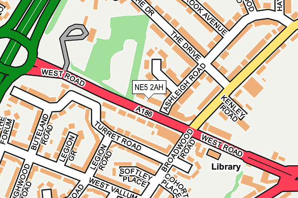
NE5 2AH lies on West Road in Newcastle Upon Tyne. NE5 2AH is located in the West Fenham electoral ward, within the metropolitan district of Newcastle upon Tyne and the English Parliamentary constituency of Newcastle upon Tyne Central. The Sub Integrated Care Board (ICB) Location is NHS North East and North Cumbria ICB - 13T and the police force is Northumbria. This postcode has been in use since January 1980.


GetTheData
Source: OS OpenMap – Local (Ordnance Survey)
Source: OS VectorMap District (Ordnance Survey)
Licence: Open Government Licence (requires attribution)
| Easting | 419984 |
| Northing | 565540 |
| Latitude | 54.984062 |
| Longitude | -1.689261 |
GetTheData
Source: Open Postcode Geo
Licence: Open Government Licence
| Street | West Road |
| Town/City | Newcastle Upon Tyne |
| Country | England |
| Postcode District | NE5 |
➜ See where NE5 is on a map ➜ Where is Newcastle upon Tyne? | |
GetTheData
Source: Land Registry Price Paid Data
Licence: Open Government Licence
Elevation or altitude of NE5 2AH as distance above sea level:
| Metres | Feet | |
|---|---|---|
| Elevation | 70m | 230ft |
Elevation is measured from the approximate centre of the postcode, to the nearest point on an OS contour line from OS Terrain 50, which has contour spacing of ten vertical metres.
➜ How high above sea level am I? Find the elevation of your current position using your device's GPS.
GetTheData
Source: Open Postcode Elevation
Licence: Open Government Licence
| Ward | West Fenham |
| Constituency | Newcastle Upon Tyne Central |
GetTheData
Source: ONS Postcode Database
Licence: Open Government Licence
| West Road | Denton Burn | 46m |
| Slatyford Lane | Denton Burn | 137m |
| Slatyford Lane | Denton Burn | 148m |
| West Road-a1 (West Road) | Denton Burn | 203m |
| West Road | Denton Burn | 217m |
| Blaydon Station | 2.5km |
| Metrocentre Station | 3.2km |
| Dunston Station | 4.8km |
GetTheData
Source: NaPTAN
Licence: Open Government Licence
| Percentage of properties with Next Generation Access | 100.0% |
| Percentage of properties with Superfast Broadband | 100.0% |
| Percentage of properties with Ultrafast Broadband | 100.0% |
| Percentage of properties with Full Fibre Broadband | 0.0% |
Superfast Broadband is between 30Mbps and 300Mbps
Ultrafast Broadband is > 300Mbps
| Median download speed | 78.1Mbps |
| Average download speed | 130.8Mbps |
| Maximum download speed | 350.00Mbps |
| Median upload speed | 1.0Mbps |
| Average upload speed | 7.2Mbps |
| Maximum upload speed | 19.53Mbps |
| Percentage of properties unable to receive 2Mbps | 0.0% |
| Percentage of properties unable to receive 5Mbps | 0.0% |
| Percentage of properties unable to receive 10Mbps | 0.0% |
| Percentage of properties unable to receive 30Mbps | 0.0% |
GetTheData
Source: Ofcom
Licence: Ofcom Terms of Use (requires attribution)
GetTheData
Source: ONS Postcode Database
Licence: Open Government Licence


➜ Get more ratings from the Food Standards Agency
GetTheData
Source: Food Standards Agency
Licence: FSA terms & conditions
| Last Collection | |||
|---|---|---|---|
| Location | Mon-Fri | Sat | Distance |
| Langdon Road | 17:45 | 11:15 | 401m |
| Etal Way | 17:30 | 11:30 | 1,140m |
| 379 West Road | 17:30 | 11:30 | 1,237m |
GetTheData
Source: Dracos
Licence: Creative Commons Attribution-ShareAlike
The below table lists the International Territorial Level (ITL) codes (formerly Nomenclature of Territorial Units for Statistics (NUTS) codes) and Local Administrative Units (LAU) codes for NE5 2AH:
| ITL 1 Code | Name |
|---|---|
| TLC | North East (England) |
| ITL 2 Code | Name |
| TLC2 | Northumberland, and Tyne and Wear |
| ITL 3 Code | Name |
| TLC22 | Tyneside |
| LAU 1 Code | Name |
| E08000021 | Newcastle upon Tyne |
GetTheData
Source: ONS Postcode Directory
Licence: Open Government Licence
The below table lists the Census Output Area (OA), Lower Layer Super Output Area (LSOA), and Middle Layer Super Output Area (MSOA) for NE5 2AH:
| Code | Name | |
|---|---|---|
| OA | E00042324 | |
| LSOA | E01008345 | Newcastle upon Tyne 019C |
| MSOA | E02001726 | Newcastle upon Tyne 019 |
GetTheData
Source: ONS Postcode Directory
Licence: Open Government Licence
| NE15 7QQ | West Road | 57m |
| NE5 2AE | Ashleigh Crescent | 72m |
| NE15 7TE | Turret Road | 84m |
| NE5 2BT | Ashleigh Road | 112m |
| NE5 2UN | Slatyford Lane | 118m |
| NE5 2UR | West Road | 126m |
| NE15 7UH | Legion Road | 149m |
| NE5 2AD | The Drive | 154m |
| NE15 7TJ | Softley Place | 163m |
| NE15 7TD | Pauline Gardens | 176m |
GetTheData
Source: Open Postcode Geo; Land Registry Price Paid Data
Licence: Open Government Licence