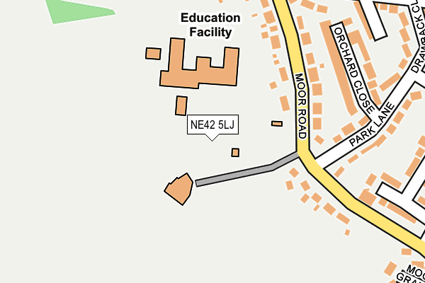
NE42 5LJ is located in the Prudhoe South electoral ward, within the unitary authority of Northumberland and the English Parliamentary constituency of Hexham. The Sub Integrated Care Board (ICB) Location is NHS North East and North Cumbria ICB - 00L and the police force is Northumbria. This postcode has been in use since January 1980.


GetTheData
Source: OS OpenMap – Local (Ordnance Survey)
Source: OS VectorMap District (Ordnance Survey)
Licence: Open Government Licence (requires attribution)
| Easting | 409620 |
| Northing | 562314 |
| Latitude | 54.955385 |
| Longitude | -1.851326 |
GetTheData
Source: Open Postcode Geo
Licence: Open Government Licence
| Country | England |
| Postcode District | NE42 |
➜ See where NE42 is on a map ➜ Where is Prudhoe? | |
GetTheData
Source: Land Registry Price Paid Data
Licence: Open Government Licence
Elevation or altitude of NE42 5LJ as distance above sea level:
| Metres | Feet | |
|---|---|---|
| Elevation | 150m | 492ft |
Elevation is measured from the approximate centre of the postcode, to the nearest point on an OS contour line from OS Terrain 50, which has contour spacing of ten vertical metres.
➜ How high above sea level am I? Find the elevation of your current position using your device's GPS.
GetTheData
Source: Open Postcode Elevation
Licence: Open Government Licence
| Ward | Prudhoe South |
| Constituency | Hexham |
GetTheData
Source: ONS Postcode Database
Licence: Open Government Licence
| Prudhoe High School (Moor Road) | Drawback | 185m |
| Park Lane | Drawback | 239m |
| Park Lane | Drawback | 242m |
| Redwell Road Junction (South Road) | Drawback | 365m |
| South Road Hillcrest (South Road) | Drawback | 367m |
| Prudhoe Station | 1.5km |
| Wylam Station | 3.2km |
| Stocksfield Station | 4.3km |
GetTheData
Source: NaPTAN
Licence: Open Government Licence
GetTheData
Source: ONS Postcode Database
Licence: Open Government Licence


➜ Get more ratings from the Food Standards Agency
GetTheData
Source: Food Standards Agency
Licence: FSA terms & conditions
| Last Collection | |||
|---|---|---|---|
| Location | Mon-Fri | Sat | Distance |
| Park Lane | 16:00 | 12:00 | 326m |
| South Road | 16:00 | 12:00 | 367m |
| Redwell Road | 16:00 | 11:45 | 649m |
GetTheData
Source: Dracos
Licence: Creative Commons Attribution-ShareAlike
The below table lists the International Territorial Level (ITL) codes (formerly Nomenclature of Territorial Units for Statistics (NUTS) codes) and Local Administrative Units (LAU) codes for NE42 5LJ:
| ITL 1 Code | Name |
|---|---|
| TLC | North East (England) |
| ITL 2 Code | Name |
| TLC2 | Northumberland, and Tyne and Wear |
| ITL 3 Code | Name |
| TLC21 | Northumberland |
| LAU 1 Code | Name |
| E06000057 | Northumberland |
GetTheData
Source: ONS Postcode Directory
Licence: Open Government Licence
The below table lists the Census Output Area (OA), Lower Layer Super Output Area (LSOA), and Middle Layer Super Output Area (MSOA) for NE42 5LJ:
| Code | Name | |
|---|---|---|
| OA | E00139965 | |
| LSOA | E01027499 | Northumberland 038C |
| MSOA | E02005731 | Northumberland 038 |
GetTheData
Source: ONS Postcode Directory
Licence: Open Government Licence
| NE42 5LL | Moor Road | 207m |
| NE42 5LH | Moor Road | 268m |
| NE42 5LP | Orchard Close | 288m |
| NE42 5LX | Grange Court | 312m |
| NE42 5LN | Park Lane | 318m |
| NE42 5LG | Drawback | 326m |
| NE42 6EZ | Highfield | 330m |
| NE42 5LB | South Road | 332m |
| NE42 5LD | Grange Terrace | 345m |
| NE42 5LW | Park Lane | 350m |
GetTheData
Source: Open Postcode Geo; Land Registry Price Paid Data
Licence: Open Government Licence