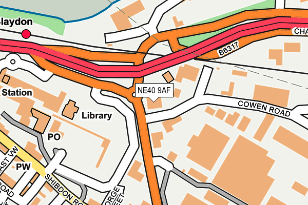
NE40 9AF is located in the Blaydon electoral ward, within the metropolitan district of Gateshead and the English Parliamentary constituency of Blaydon. The Sub Integrated Care Board (ICB) Location is NHS North East and North Cumbria ICB - 13T and the police force is Northumbria. This postcode has been in use since March 2010.


GetTheData
Source: OS OpenMap – Local (Ordnance Survey)
Source: OS VectorMap District (Ordnance Survey)
Licence: Open Government Licence (requires attribution)
| Easting | 418796 |
| Northing | 563372 |
| Latitude | 54.964626 |
| Longitude | -1.707966 |
GetTheData
Source: Open Postcode Geo
Licence: Open Government Licence
| Country | England |
| Postcode District | NE40 |
➜ See where NE40 is on a map ➜ Where is Blaydon? | |
GetTheData
Source: Land Registry Price Paid Data
Licence: Open Government Licence
Elevation or altitude of NE40 9AF as distance above sea level:
| Metres | Feet | |
|---|---|---|
| Elevation | 10m | 33ft |
Elevation is measured from the approximate centre of the postcode, to the nearest point on an OS contour line from OS Terrain 50, which has contour spacing of ten vertical metres.
➜ How high above sea level am I? Find the elevation of your current position using your device's GPS.
GetTheData
Source: Open Postcode Elevation
Licence: Open Government Licence
| Ward | Blaydon |
| Constituency | Blaydon |
GetTheData
Source: ONS Postcode Database
Licence: Open Government Licence
| Chainbridge Road-railway Crossing (Chainbridge Road) | Blaydon | 153m |
| Chainbridge Road-railway Crossing (Chainbridge Road) | Blaydon | 172m |
| Shibdon Road-larch Road (Shibdon Road) | Blaydon | 251m |
| Larch Road | Blaydon | 275m |
| Shibdon Road-east View (Shibdon Road) | Blaydon | 291m |
| Blaydon Station | 0.3km |
| Metrocentre Station | 2.8km |
| Dunston Station | 4.5km |
GetTheData
Source: NaPTAN
Licence: Open Government Licence
GetTheData
Source: ONS Postcode Database
Licence: Open Government Licence


➜ Get more ratings from the Food Standards Agency
GetTheData
Source: Food Standards Agency
Licence: FSA terms & conditions
| Last Collection | |||
|---|---|---|---|
| Location | Mon-Fri | Sat | Distance |
| Blaydon Delivery Office | 19:00 | 11:00 | 21m |
| Cowan Road | 18:30 | 21m | |
| Blaydon Post Office | 17:15 | 12:15 | 180m |
GetTheData
Source: Dracos
Licence: Creative Commons Attribution-ShareAlike
The below table lists the International Territorial Level (ITL) codes (formerly Nomenclature of Territorial Units for Statistics (NUTS) codes) and Local Administrative Units (LAU) codes for NE40 9AF:
| ITL 1 Code | Name |
|---|---|
| TLC | North East (England) |
| ITL 2 Code | Name |
| TLC2 | Northumberland, and Tyne and Wear |
| ITL 3 Code | Name |
| TLC22 | Tyneside |
| LAU 1 Code | Name |
| E08000037 | Gateshead |
GetTheData
Source: ONS Postcode Directory
Licence: Open Government Licence
The below table lists the Census Output Area (OA), Lower Layer Super Output Area (LSOA), and Middle Layer Super Output Area (MSOA) for NE40 9AF:
| Code | Name | |
|---|---|---|
| OA | E00041460 | |
| LSOA | E01008181 | Gateshead 005C |
| MSOA | E02001686 | Gateshead 005 |
GetTheData
Source: ONS Postcode Directory
Licence: Open Government Licence
| NE21 5BT | The Precinct | 127m |
| NE21 5TW | Cowen Road | 246m |
| NE21 5RU | Factory Road | 253m |
| NE21 5PU | Lucy Street | 283m |
| NE21 5AE | Shibdon Road | 308m |
| NE21 5AF | Shibdon Road | 312m |
| NE21 5AL | Larch Road | 315m |
| NE21 4QB | Dene Road | 330m |
| NE21 5AH | East View | 331m |
| NE21 4QJ | Mabel Street | 383m |
GetTheData
Source: Open Postcode Geo; Land Registry Price Paid Data
Licence: Open Government Licence