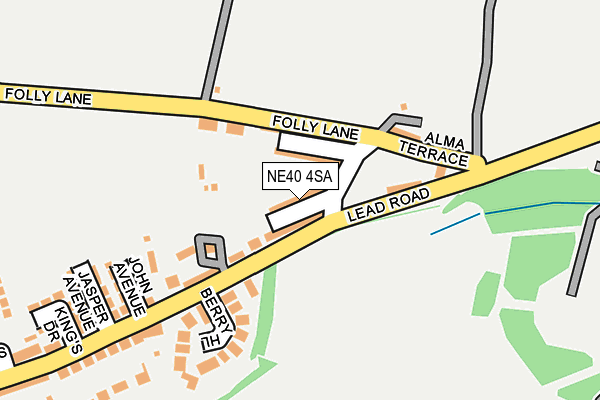
NE40 4SA lies on Rose Terrace in Greenside, Ryton. NE40 4SA is located in the Crawcrook and Greenside electoral ward, within the metropolitan district of Gateshead and the English Parliamentary constituency of Blaydon. The Sub Integrated Care Board (ICB) Location is NHS North East and North Cumbria ICB - 13T and the police force is Northumbria. This postcode has been in use since January 1980.


GetTheData
Source: OS OpenMap – Local (Ordnance Survey)
Source: OS VectorMap District (Ordnance Survey)
Licence: Open Government Licence (requires attribution)
| Easting | 415046 |
| Northing | 562504 |
| Latitude | 54.956952 |
| Longitude | -1.766580 |
GetTheData
Source: Open Postcode Geo
Licence: Open Government Licence
| Street | Rose Terrace |
| Locality | Greenside |
| Town/City | Ryton |
| Country | England |
| Postcode District | NE40 |
➜ See where NE40 is on a map ➜ Where is Greenside? | |
GetTheData
Source: Land Registry Price Paid Data
Licence: Open Government Licence
Elevation or altitude of NE40 4SA as distance above sea level:
| Metres | Feet | |
|---|---|---|
| Elevation | 120m | 394ft |
Elevation is measured from the approximate centre of the postcode, to the nearest point on an OS contour line from OS Terrain 50, which has contour spacing of ten vertical metres.
➜ How high above sea level am I? Find the elevation of your current position using your device's GPS.
GetTheData
Source: Open Postcode Elevation
Licence: Open Government Licence
| Ward | Crawcrook And Greenside |
| Constituency | Blaydon |
GetTheData
Source: ONS Postcode Database
Licence: Open Government Licence
| Lead Lane-folly Farm (Lead Lane) | The Folly | 60m |
| Lead Road-croxdale Terrace (Lead Road) | The Folly | 71m |
| Folly Lane-alma Terrace (Alma Terrace) | The Folly | 91m |
| Folly Lane-alma Terrace (Folly Lane) | The Folly | 110m |
| Folly (Lead Road) | The Folly | 246m |
| Blaydon Station | 3.6km |
| Wylam Station | 3.6km |
GetTheData
Source: NaPTAN
Licence: Open Government Licence
| Percentage of properties with Next Generation Access | 100.0% |
| Percentage of properties with Superfast Broadband | 0.0% |
| Percentage of properties with Ultrafast Broadband | 0.0% |
| Percentage of properties with Full Fibre Broadband | 0.0% |
Superfast Broadband is between 30Mbps and 300Mbps
Ultrafast Broadband is > 300Mbps
| Median download speed | 14.2Mbps |
| Average download speed | 11.4Mbps |
| Maximum download speed | 21.24Mbps |
| Median upload speed | 1.0Mbps |
| Average upload speed | 1.0Mbps |
| Maximum upload speed | 1.29Mbps |
| Percentage of properties unable to receive 2Mbps | 0.0% |
| Percentage of properties unable to receive 5Mbps | 0.0% |
| Percentage of properties unable to receive 10Mbps | 0.0% |
| Percentage of properties unable to receive 30Mbps | 100.0% |
GetTheData
Source: Ofcom
Licence: Ofcom Terms of Use (requires attribution)
Estimated total energy consumption in NE40 4SA by fuel type, 2015.
| Consumption (kWh) | 142,810 |
|---|---|
| Meter count | 13 |
| Mean (kWh/meter) | 10,985 |
| Median (kWh/meter) | 10,841 |
| Consumption (kWh) | 44,771 |
|---|---|
| Meter count | 13 |
| Mean (kWh/meter) | 3,444 |
| Median (kWh/meter) | 3,387 |
GetTheData
Source: Postcode level gas estimates: 2015 (experimental)
Source: Postcode level electricity estimates: 2015 (experimental)
Licence: Open Government Licence
GetTheData
Source: ONS Postcode Database
Licence: Open Government Licence


➜ Get more ratings from the Food Standards Agency
GetTheData
Source: Food Standards Agency
Licence: FSA terms & conditions
| Last Collection | |||
|---|---|---|---|
| Location | Mon-Fri | Sat | Distance |
| Lead Road | 16:30 | 10:30 | 277m |
| Folly Lane | 17:45 | 10:30 | 423m |
| Woodside Lane | 16:15 | 10:30 | 838m |
GetTheData
Source: Dracos
Licence: Creative Commons Attribution-ShareAlike
The below table lists the International Territorial Level (ITL) codes (formerly Nomenclature of Territorial Units for Statistics (NUTS) codes) and Local Administrative Units (LAU) codes for NE40 4SA:
| ITL 1 Code | Name |
|---|---|
| TLC | North East (England) |
| ITL 2 Code | Name |
| TLC2 | Northumberland, and Tyne and Wear |
| ITL 3 Code | Name |
| TLC22 | Tyneside |
| LAU 1 Code | Name |
| E08000037 | Gateshead |
GetTheData
Source: ONS Postcode Directory
Licence: Open Government Licence
The below table lists the Census Output Area (OA), Lower Layer Super Output Area (LSOA), and Middle Layer Super Output Area (MSOA) for NE40 4SA:
| Code | Name | |
|---|---|---|
| OA | E00041548 | |
| LSOA | E01008195 | Gateshead 002A |
| MSOA | E02001683 | Gateshead 002 |
GetTheData
Source: ONS Postcode Directory
Licence: Open Government Licence
| NE40 4RZ | Croxdale Terrace | 24m |
| NE40 4SB | Edwin Terrace | 45m |
| NE40 4SD | Alma Terrace | 66m |
| NE40 4RY | Folly Cottages | 102m |
| NE40 4SE | Folly Yard | 121m |
| NE40 4RX | Landscape Terrace | 127m |
| NE40 4RD | 128m | |
| NE40 4ST | 142m | |
| NE40 4HS | Berry Hill | 149m |
| NE40 4RU | The Folly | 185m |
GetTheData
Source: Open Postcode Geo; Land Registry Price Paid Data
Licence: Open Government Licence