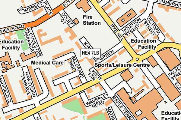
NE4 7LB is located in the Elswick electoral ward, within the metropolitan district of Newcastle upon Tyne and the English Parliamentary constituency of Newcastle upon Tyne Central. The Sub Integrated Care Board (ICB) Location is NHS North East and North Cumbria ICB - 13T and the police force is Northumbria. This postcode has been in use since January 1980.


GetTheData
Source: OS OpenMap – Local (Ordnance Survey)
Source: OS VectorMap District (Ordnance Survey)
Licence: Open Government Licence (requires attribution)
| Easting | 423673 |
| Northing | 563816 |
| Latitude | 54.968409 |
| Longitude | -1.631760 |
GetTheData
Source: Open Postcode Geo
Licence: Open Government Licence
| Country | England |
| Postcode District | NE4 |
➜ See where NE4 is on a map ➜ Where is Newcastle upon Tyne? | |
GetTheData
Source: Land Registry Price Paid Data
Licence: Open Government Licence
Elevation or altitude of NE4 7LB as distance above sea level:
| Metres | Feet | |
|---|---|---|
| Elevation | 70m | 230ft |
Elevation is measured from the approximate centre of the postcode, to the nearest point on an OS contour line from OS Terrain 50, which has contour spacing of ten vertical metres.
➜ How high above sea level am I? Find the elevation of your current position using your device's GPS.
GetTheData
Source: Open Postcode Elevation
Licence: Open Government Licence
| Ward | Elswick |
| Constituency | Newcastle Upon Tyne Central |
GetTheData
Source: ONS Postcode Database
Licence: Open Government Licence
| Westmorland Road-rye Hill (Westmorland Road) | Elswick | 76m |
| Westmorland Road-rye Hill (Westmorland Road) | Elswick | 127m |
| Rye Hill | Elswick | 131m |
| Rye Hill | Elswick | 135m |
| Westmorland Road | Elswick | 185m |
| St James (Tyne And Wear Metro Station) (Strawberry Place) | Newcastle Upon Tyne | 935m |
| Central Station (Tyne And Wear Metro Station) (Neville Street) | Newcastle Upon Tyne | 1,004m |
| Monument (Tyne And Wear Metro Station) (Blackett Street) | Newcastle Upon Tyne | 1,307m |
| Haymarket (Tyne And Wear Metro Station) (Percy Street) | Newcastle Upon Tyne | 1,528m |
| Newcastle Station | 0.9km |
| Manors Station | 1.8km |
| Dunston Station | 2.1km |
GetTheData
Source: NaPTAN
Licence: Open Government Licence
GetTheData
Source: ONS Postcode Database
Licence: Open Government Licence


➜ Get more ratings from the Food Standards Agency
GetTheData
Source: Food Standards Agency
Licence: FSA terms & conditions
| Last Collection | |||
|---|---|---|---|
| Location | Mon-Fri | Sat | Distance |
| East Parade | 17:45 | 12:00 | 254m |
| Rye Hill | 18:15 | 12:00 | 263m |
| Ashfield | 18:00 | 12:00 | 343m |
GetTheData
Source: Dracos
Licence: Creative Commons Attribution-ShareAlike
The below table lists the International Territorial Level (ITL) codes (formerly Nomenclature of Territorial Units for Statistics (NUTS) codes) and Local Administrative Units (LAU) codes for NE4 7LB:
| ITL 1 Code | Name |
|---|---|
| TLC | North East (England) |
| ITL 2 Code | Name |
| TLC2 | Northumberland, and Tyne and Wear |
| ITL 3 Code | Name |
| TLC22 | Tyneside |
| LAU 1 Code | Name |
| E08000021 | Newcastle upon Tyne |
GetTheData
Source: ONS Postcode Directory
Licence: Open Government Licence
The below table lists the Census Output Area (OA), Lower Layer Super Output Area (LSOA), and Middle Layer Super Output Area (MSOA) for NE4 7LB:
| Code | Name | |
|---|---|---|
| OA | E00042827 | |
| LSOA | E01008439 | Newcastle upon Tyne 024E |
| MSOA | E02001731 | Newcastle upon Tyne 024 |
GetTheData
Source: ONS Postcode Directory
Licence: Open Government Licence
| NE4 6HG | Kirkdale Green | 55m |
| NE4 6HX | Kirkdale Green | 59m |
| NE4 6HZ | Houston Street | 168m |
| NE4 6JA | Houston Court | 172m |
| NE4 6HT | Drybeck Court | 188m |
| NE4 6RJ | Hawthorn Terrace | 198m |
| NE4 7SH | Mather Road | 214m |
| NE4 7JU | Victoria Street | 227m |
| NE4 7HP | Hawthorn Walk | 229m |
| NE4 6ES | Elswick Road | 235m |
GetTheData
Source: Open Postcode Geo; Land Registry Price Paid Data
Licence: Open Government Licence