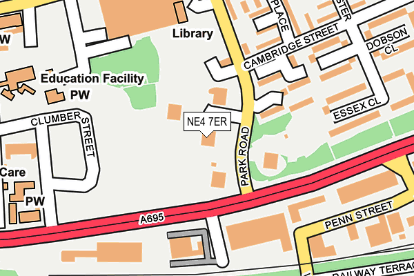
NE4 7ER is located in the Elswick electoral ward, within the metropolitan district of Newcastle upon Tyne and the English Parliamentary constituency of Newcastle upon Tyne Central. The Sub Integrated Care Board (ICB) Location is NHS North East and North Cumbria ICB - 13T and the police force is Northumbria. This postcode has been in use since May 2009.


GetTheData
Source: OS OpenMap – Local (Ordnance Survey)
Source: OS VectorMap District (Ordnance Survey)
Licence: Open Government Licence (requires attribution)
| Easting | 423438 |
| Northing | 563341 |
| Latitude | 54.964152 |
| Longitude | -1.635469 |
GetTheData
Source: Open Postcode Geo
Licence: Open Government Licence
| Country | England |
| Postcode District | NE4 |
➜ See where NE4 is on a map ➜ Where is Newcastle upon Tyne? | |
GetTheData
Source: Land Registry Price Paid Data
Licence: Open Government Licence
Elevation or altitude of NE4 7ER as distance above sea level:
| Metres | Feet | |
|---|---|---|
| Elevation | 40m | 131ft |
Elevation is measured from the approximate centre of the postcode, to the nearest point on an OS contour line from OS Terrain 50, which has contour spacing of ten vertical metres.
➜ How high above sea level am I? Find the elevation of your current position using your device's GPS.
GetTheData
Source: Open Postcode Elevation
Licence: Open Government Licence
| Ward | Elswick |
| Constituency | Newcastle Upon Tyne Central |
GetTheData
Source: ONS Postcode Database
Licence: Open Government Licence
| Scotswood Road-park Road (Scotswood Road) | Elswick | 131m |
| Scotswood Road-dunn Street (Scotswood Road) | Elswick | 157m |
| Water Street | Elswick | 251m |
| Cruddas Park (Westmorland Road) | Elswick | 266m |
| Cruddas Park (Westmorland Road) | Elswick | 275m |
| Central Station (Tyne And Wear Metro Station) (Neville Street) | Newcastle Upon Tyne | 1,356m |
| St James (Tyne And Wear Metro Station) (Strawberry Place) | Newcastle Upon Tyne | 1,442m |
| Monument (Tyne And Wear Metro Station) (Blackett Street) | Newcastle Upon Tyne | 1,761m |
| Haymarket (Tyne And Wear Metro Station) (Percy Street) | Newcastle Upon Tyne | 2,030m |
| Newcastle Station | 1.3km |
| Dunston Station | 1.6km |
| Metrocentre Station | 2km |
GetTheData
Source: NaPTAN
Licence: Open Government Licence
| Percentage of properties with Next Generation Access | 100.0% |
| Percentage of properties with Superfast Broadband | 100.0% |
| Percentage of properties with Ultrafast Broadband | 100.0% |
| Percentage of properties with Full Fibre Broadband | 100.0% |
Superfast Broadband is between 30Mbps and 300Mbps
Ultrafast Broadband is > 300Mbps
| Median download speed | 40.0Mbps |
| Average download speed | 34.7Mbps |
| Maximum download speed | 62.92Mbps |
| Median upload speed | 9.8Mbps |
| Average upload speed | 9.0Mbps |
| Maximum upload speed | 20.00Mbps |
| Percentage of properties unable to receive 2Mbps | 0.0% |
| Percentage of properties unable to receive 5Mbps | 0.0% |
| Percentage of properties unable to receive 10Mbps | 0.0% |
| Percentage of properties unable to receive 30Mbps | 0.0% |
GetTheData
Source: Ofcom
Licence: Ofcom Terms of Use (requires attribution)
Estimated total energy consumption in NE4 7ER by fuel type, 2015.
| Consumption (kWh) | 148,852 |
|---|---|
| Meter count | 68 |
| Mean (kWh/meter) | 2,189 |
| Median (kWh/meter) | 1,730 |
GetTheData
Source: Postcode level gas estimates: 2015 (experimental)
Source: Postcode level electricity estimates: 2015 (experimental)
Licence: Open Government Licence
GetTheData
Source: ONS Postcode Database
Licence: Open Government Licence


➜ Get more ratings from the Food Standards Agency
GetTheData
Source: Food Standards Agency
Licence: FSA terms & conditions
| Last Collection | |||
|---|---|---|---|
| Location | Mon-Fri | Sat | Distance |
| Cambridge Street | 17:30 | 12:00 | 166m |
| Cruddas Park | 17:45 | 11:45 | 251m |
| Scotswood Road | 17:30 | 11:30 | 486m |
GetTheData
Source: Dracos
Licence: Creative Commons Attribution-ShareAlike
The below table lists the International Territorial Level (ITL) codes (formerly Nomenclature of Territorial Units for Statistics (NUTS) codes) and Local Administrative Units (LAU) codes for NE4 7ER:
| ITL 1 Code | Name |
|---|---|
| TLC | North East (England) |
| ITL 2 Code | Name |
| TLC2 | Northumberland, and Tyne and Wear |
| ITL 3 Code | Name |
| TLC22 | Tyneside |
| LAU 1 Code | Name |
| E08000021 | Newcastle upon Tyne |
GetTheData
Source: ONS Postcode Directory
Licence: Open Government Licence
The below table lists the Census Output Area (OA), Lower Layer Super Output Area (LSOA), and Middle Layer Super Output Area (MSOA) for NE4 7ER:
| Code | Name | |
|---|---|---|
| OA | E00042818 | |
| LSOA | E01008438 | Newcastle upon Tyne 029G |
| MSOA | E02001736 | Newcastle upon Tyne 029 |
GetTheData
Source: ONS Postcode Directory
Licence: Open Government Licence
| NE4 7DX | Park Road | 98m |
| NE4 7HW | Hawthorn Walk | 208m |
| NE4 7HR | Hawthorn Place | 209m |
| NE4 7EB | Charlotte Close | 216m |
| NE4 7HN | Cambridge Street | 234m |
| NE4 7DT | Essex Close | 248m |
| NE4 7BG | Penn Street | 278m |
| NE4 7HS | Gloucester Way | 281m |
| NE4 7HP | Hawthorn Walk | 302m |
| NE4 6QZ | Westmorland Road | 307m |
GetTheData
Source: Open Postcode Geo; Land Registry Price Paid Data
Licence: Open Government Licence