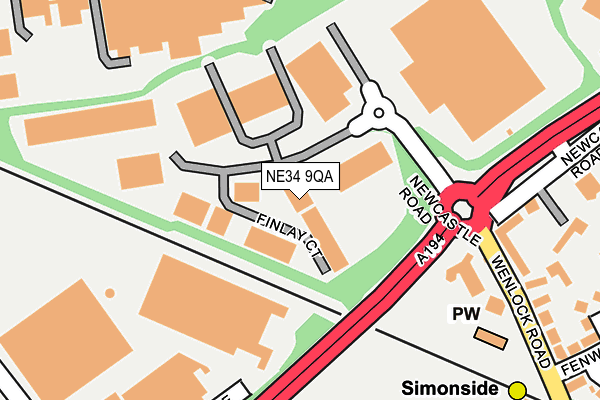
NE34 9QA lies on Finlay Court in South Shields. NE34 9QA is located in the Bede electoral ward, within the metropolitan district of South Tyneside and the English Parliamentary constituency of Jarrow. The Sub Integrated Care Board (ICB) Location is NHS North East and North Cumbria ICB - 00N and the police force is Northumbria. This postcode has been in use since July 2007.


GetTheData
Source: OS OpenMap – Local (Ordnance Survey)
Source: OS VectorMap District (Ordnance Survey)
Licence: Open Government Licence (requires attribution)
| Easting | 434742 |
| Northing | 564445 |
| Latitude | 54.973415 |
| Longitude | -1.458793 |
GetTheData
Source: Open Postcode Geo
Licence: Open Government Licence
| Street | Finlay Court |
| Town/City | South Shields |
| Country | England |
| Postcode District | NE34 |
➜ See where NE34 is on a map ➜ Where is Jarrow? | |
GetTheData
Source: Land Registry Price Paid Data
Licence: Open Government Licence
Elevation or altitude of NE34 9QA as distance above sea level:
| Metres | Feet | |
|---|---|---|
| Elevation | 10m | 33ft |
Elevation is measured from the approximate centre of the postcode, to the nearest point on an OS contour line from OS Terrain 50, which has contour spacing of ten vertical metres.
➜ How high above sea level am I? Find the elevation of your current position using your device's GPS.
GetTheData
Source: Open Postcode Elevation
Licence: Open Government Licence
| Ward | Bede |
| Constituency | Jarrow |
GetTheData
Source: ONS Postcode Database
Licence: Open Government Licence
| Newcastle Road-simonside Arms (Newcastle Road) | Simonside | 234m |
| Wenlock Road-church (Wenlock Road) | Simonside | 253m |
| Newcastle Road - Simonside Hall (Newcastle Road) | Simonside | 294m |
| Bedesway | Bede | 312m |
| Newcastle Road-colman Avenue (Newcastle Road) | Simonside | 333m |
| Simonside (Tyne And Wear Metro Station) (Not Specified) | Simonside | 340m |
| Bede (Tyne And Wear Metro Station) (Monksway) | Bede | 422m |
| Tyne Dock (Tyne And Wear Metro Station) (Napier Street) | Tyne Dock | 1,137m |
| Brockley Whins Station | 1.6km |
| East Boldon Station | 3.9km |
| Seaburn Station | 6.7km |
GetTheData
Source: NaPTAN
Licence: Open Government Licence
| Median download speed | 47.9Mbps |
| Average download speed | 46.0Mbps |
| Maximum download speed | 55.89Mbps |
| Median upload speed | 7.9Mbps |
| Average upload speed | 8.4Mbps |
| Maximum upload speed | 11.28Mbps |
GetTheData
Source: Ofcom
Licence: Ofcom Terms of Use (requires attribution)
GetTheData
Source: ONS Postcode Database
Licence: Open Government Licence


➜ Get more ratings from the Food Standards Agency
GetTheData
Source: Food Standards Agency
Licence: FSA terms & conditions
| Last Collection | |||
|---|---|---|---|
| Location | Mon-Fri | Sat | Distance |
| Wenlock Road | 16:00 | 10:30 | 196m |
| Bede Trading Estate | 17:30 | 10:30 | 503m |
| Bainbridge Avenue | 16:00 | 10:30 | 581m |
GetTheData
Source: Dracos
Licence: Creative Commons Attribution-ShareAlike
The below table lists the International Territorial Level (ITL) codes (formerly Nomenclature of Territorial Units for Statistics (NUTS) codes) and Local Administrative Units (LAU) codes for NE34 9QA:
| ITL 1 Code | Name |
|---|---|
| TLC | North East (England) |
| ITL 2 Code | Name |
| TLC2 | Northumberland, and Tyne and Wear |
| ITL 3 Code | Name |
| TLC22 | Tyneside |
| LAU 1 Code | Name |
| E08000023 | South Tyneside |
GetTheData
Source: ONS Postcode Directory
Licence: Open Government Licence
The below table lists the Census Output Area (OA), Lower Layer Super Output Area (LSOA), and Middle Layer Super Output Area (MSOA) for NE34 9QA:
| Code | Name | |
|---|---|---|
| OA | E00043680 | |
| LSOA | E01008601 | South Tyneside 012A |
| MSOA | E02001779 | South Tyneside 012 |
GetTheData
Source: ONS Postcode Directory
Licence: Open Government Licence
| NE34 9PZ | Waldridge Way | 112m |
| NE34 9BP | Wenlock Road | 244m |
| NE34 9BW | Simonside Hall | 265m |
| NE34 9PH | Shaftesbury Avenue | 305m |
| NE34 9AA | Newcastle Road | 307m |
| NE34 9AD | Margaret Grove | 336m |
| NE34 9AE | Hyperion Avenue | 347m |
| NE34 9DE | Simonside Hall | 356m |
| NE34 9QJ | Newcastle Road | 381m |
| NE34 9AJ | Fenwick Avenue | 386m |
GetTheData
Source: Open Postcode Geo; Land Registry Price Paid Data
Licence: Open Government Licence