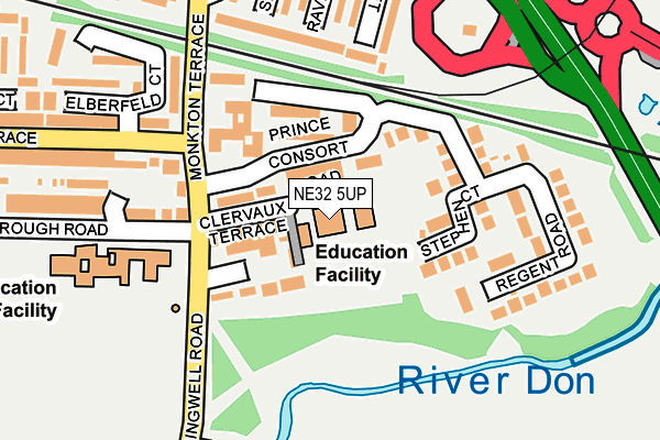
NE32 5UP is located in the Primrose electoral ward, within the metropolitan district of South Tyneside and the English Parliamentary constituency of Jarrow. The Sub Integrated Care Board (ICB) Location is NHS North East and North Cumbria ICB - 00N and the police force is Northumbria. This postcode has been in use since January 1980.


GetTheData
Source: OS OpenMap – Local (Ordnance Survey)
Source: OS VectorMap District (Ordnance Survey)
Licence: Open Government Licence (requires attribution)
| Easting | 433044 |
| Northing | 564714 |
| Latitude | 54.975955 |
| Longitude | -1.485300 |
GetTheData
Source: Open Postcode Geo
Licence: Open Government Licence
| Country | England |
| Postcode District | NE32 |
➜ See where NE32 is on a map ➜ Where is Jarrow? | |
GetTheData
Source: Land Registry Price Paid Data
Licence: Open Government Licence
Elevation or altitude of NE32 5UP as distance above sea level:
| Metres | Feet | |
|---|---|---|
| Elevation | 10m | 33ft |
Elevation is measured from the approximate centre of the postcode, to the nearest point on an OS contour line from OS Terrain 50, which has contour spacing of ten vertical metres.
➜ How high above sea level am I? Find the elevation of your current position using your device's GPS.
GetTheData
Source: Open Postcode Elevation
Licence: Open Government Licence
| Ward | Primrose |
| Constituency | Jarrow |
GetTheData
Source: ONS Postcode Database
Licence: Open Government Licence
| Monkton Terrace-prince Consort Road (Monkton Terrace) | Jarrow | 51m |
| Monkton Terrace-elberfield Court (Monkton Terrace) | Jarrow | 139m |
| Springwell Road-cemetery Road (Springwell Road) | Jarrow | 151m |
| Croft Terrace | Jarrow | 152m |
| Howard Street-seine Court (Howard Street) | Jarrow | 291m |
| Jarrow (Tyne And Wear Metro Station) (Grant Street) | Jarrow | 666m |
| Bede (Tyne And Wear Metro Station) (Monksway) | Bede | 1,301m |
| Brockley Whins Station | 2.4km |
| Heworth Station | 5.3km |
| East Boldon Station | 5.3km |
GetTheData
Source: NaPTAN
Licence: Open Government Licence
GetTheData
Source: ONS Postcode Database
Licence: Open Government Licence


➜ Get more ratings from the Food Standards Agency
GetTheData
Source: Food Standards Agency
Licence: FSA terms & conditions
| Last Collection | |||
|---|---|---|---|
| Location | Mon-Fri | Sat | Distance |
| Monkton Terrace | 17:00 | 10:30 | 39m |
| Croft Terrace | 17:15 | 11:30 | 439m |
| Bede Burn Road | 16:15 | 10:30 | 546m |
GetTheData
Source: Dracos
Licence: Creative Commons Attribution-ShareAlike
The below table lists the International Territorial Level (ITL) codes (formerly Nomenclature of Territorial Units for Statistics (NUTS) codes) and Local Administrative Units (LAU) codes for NE32 5UP:
| ITL 1 Code | Name |
|---|---|
| TLC | North East (England) |
| ITL 2 Code | Name |
| TLC2 | Northumberland, and Tyne and Wear |
| ITL 3 Code | Name |
| TLC22 | Tyneside |
| LAU 1 Code | Name |
| E08000023 | South Tyneside |
GetTheData
Source: ONS Postcode Directory
Licence: Open Government Licence
The below table lists the Census Output Area (OA), Lower Layer Super Output Area (LSOA), and Middle Layer Super Output Area (MSOA) for NE32 5UP:
| Code | Name | |
|---|---|---|
| OA | E00043957 | |
| LSOA | E01008661 | South Tyneside 007D |
| MSOA | E02001774 | South Tyneside 007 |
GetTheData
Source: ONS Postcode Directory
Licence: Open Government Licence
| NE32 5XX | Prince Consort Road | 39m |
| NE32 5UT | Springwell Avenue | 49m |
| NE32 5XW | Borough Road | 134m |
| NE32 5XY | Prince Consort Road | 135m |
| NE32 5BU | Elber Feld Court | 144m |
| NE32 5UZ | Monkton Terrace | 148m |
| NE32 5XH | Croft Terrace | 161m |
| NE32 5BZ | Elber Feld Court | 178m |
| NE32 5BY | Elber Feld Court | 187m |
| NE32 3BJ | Epinay Walk | 193m |
GetTheData
Source: Open Postcode Geo; Land Registry Price Paid Data
Licence: Open Government Licence